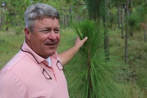
Robbie Green has a story like many who have staked their place in the quail woods of the Red Hills.
His grandfather told of rolling, sand-clay hills with flat-topped longleaf, mixed loblolly and shortleaf pine forests rich with abundant coveys of birds that supported impressive hunts around his hometown of Meridian, Mississippi.
That world slowly began to fade away as old-growth shifted into pine plantations and the timber industry became king.
Fast forward to today, and Green spends his days managing more than 11,500 acres on Tallokas and Osceola, two of Southwest Georgia’s premier hunting properties that have been managed intensively for wild quail since the mid-1900s
His role has expanded to be more than a land manager; Green sees his role as one of a tradition keeper and memory maker for the families he works with. At the same time, he remains keenly focused on historical land use and managing the land for a diversity of wildlife.
He didn’t come by wildlife management immediately as a young man. Green hunted and fished and thought the educational path was just a way to spend more time in the woods.
But he quickly developed a passion instead for where the hand of man fit into shaping and preserving the natural ecosystem.
That led him from Mississippi State University to the “funky” world of the Red Hills when he visited Tall Timbers to work with former MSU graduate students whom he had assisted on various research projects and then sought a job and a permanent place for his growing family.
All the while, he worked hard on various properties, gaining experience and following that ardor for the land while working at Mistletoe Plantation and Disston Plantation.
He started working at Osceola and Tallokas managing the properties for the Williams and Parker families in 2012, and by then had found that drive for seeing the results of working the land.
“Once you start becoming interested in something, you become a student. You develop a passion,” Green said. “It works out. You keep doing the right thing and follow that passion.”
Native ground cover and generating value from every acre
The two properties Green manages are reverse images of each other.
More than 70% of Tallokas is made up of native ground cover and longleaf pine, a relic landscape that is found in just a handful of the places where it historically flourished.
Osceola is mostly old field habitat where longleaf reforestation has become a primary goal.
Both are a mecca for wild quail, which are generally found at above two birds per acre.
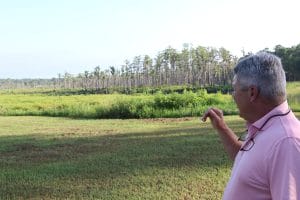
Green with a young longleaf at Tallokas, which is 70% native ground cover
Interspersed are regularly-hunted dove fields and agricultural plots that help offset costs, but the property is maintained almost exclusively with fire.
Listen to Green talk about it, and it’s easy to tell his affinity for the intact landscape but also his passion to keep it that way.
He’s been tasked with managing the properties for 200 years with the resources on hand for 100 years.
Timbering, farming, hunting and pine straw leases offset a third of the annual budget.
But one of his biggest emerging issues is balancing managing for quail, timbering and other activities efficiently to get the most out of the entirety of the properties.
He and his team call it “Going Dutch,” or compartmentalizing each aspect of the property in a location that makes the most sense so that each part can flourish akin to practices in Holland.
So often, large properties have agricultural fields interspersed throughout the woods, or there is overlap between hunting grounds and growing trees, Green said. That reduces efficiency and can tax limited resources.
The solution was to compartmentalize the different practices.
Farm where it’s appropriate and can be done at a scale that is profitable. Grow timber where it makes sense and manage and hunt for quail and other game where that makes sense.
Green is always looking for ways to improve the property in small ways that save resources but is careful to keep the landscape intact.
The Aldo Leopold quote, “The first rule of intelligent tinkering is to keep all the pieces,” is a Green favorite.
“You want it to be resilient,” he said. “And the more complex it is, the more resilient.”
He’s also seeing more of an emergence in the spread of Cogon grass, Lespedeza biocolor and other sod-forming grasses which can dominate quality wildlife habitat. There’s an art to managing the need to cut timber and reducing the prevalence of invasives that can quickly take over.
“A lot of your problems with invasive are the result of over management or over disturbance,” Green said. “So, it’s finding that balance. We have to cut timber for revenue, to stay in the quail business, but that opens the door from time to time for Cogon grass or Japanese climbing fern.”
Tall Timbers has been actively engaged at the federal level as an advocate for prescribed fire use on private and public lands. In addition, we have deployed new air quality research in Southwest Georgia and are raising funds to support science focused on smoke management and air quality.
Reduction in burning could be catastrophic economically and from an environmental standpoint, Green said.
“If we lose fire, we’re done. We’re out of the game. What are we creating? Is it going to look like something out West if we’re not using fire regularly in the Red Hills?” he said. “It’s going to create a massive problem.”
The tufts of wiregrass and mix of mature longleaf and seedlings at Tallokas are one of the largest sections of complete native ground cover in the Red Hills.
It’s a unique landscape that harkens back to Green’s childhood but is also one that is a land manager’s dream. The cost to manage Tallokas, almost exclusively using prescribed fire, is significantly lower because of the native groundcover.
“Why it never got disturbed, why it never got clear cut, I don’t know,” he said. “It didn’t, though, and thank God it didn’t because that’s what I really like. It’s so rare, it’s so special, it’s such an easy thing to manage when you do it right, when you follow the right way to do it.”
Prescribed fire wasn’t a huge topic during his schooling at Mississippi State. It was talked about, but not as a large-scale land management tool like it is in the Red Hills. That was something Green had to learn once he made it to the region working under Ray Gainey at Mistletoe Plantation.
“All it needs is fire,” he said. “And fire’s cheap versus tractors and equipment and people in the seats and the cost of fuel and all of that.”
A history of fire under the water line
Everything has its place, but it’s the historic interconnection that holds Green’s interest.
An extensive dry-down and cleanup of Brice’s Pond, a 1,000 acre duck hunting haven for the owners of Tallokas and their guests, is a chance to incorporate management of overgrown aquatic vegetation that has choked out parts of the cypress tree ringed impoundment.
That involves scraping muck from the bottom or harrowing it in to allow a clean slate for plants to grow once the water refills.
The history of Brice’s Pond, however has captured the interest of Green and researchers at Tall Timbers.
Green at Brice’s Pond, which is undergoing a dry-down and cleanup of aquatic vegetation
Built sometime in the mid-1800’s, the pond is positioned in the center of Tallokas proper and drains into the Okapilco Creek that runs through Tallokas. It was created to grow rice and used to generate power for a grist mill long before it was used as a duck hunting pond.
The need to incorporate aquatic management came after the old dam was strengthened and became less susceptible to blowing out in heavy rains. The pond was restored in the early 2000s, but without a way to drain periodically, duck numbers began to dwindle over the years as the pond became overgrown.
It was a point where Green saw the connections in the landscapes across the whole property.
“It became apparent to us that we had to do something, you know, something was wrong,” Green said. “The way Brice’s Pond fits into this, I think, from a sustainability standpoint is – a system, a piece of land, a piece of property – is stronger with the more parts that you can maintain and protect and add to diversity. Strength in that diversity of habitats and systems that ecological strength is what I’m looking for.”
In addition to maintaining the pond for hunting, the drawdown is revealing the history of fire on the landscape.
On the outside of the dam, the woods are a mix of pine uplands interspersed with ephemeral marshes, cypress domes and pitcher plants that have seen regular fire for eons.
The same landscape was likely present before the pond was created and logs cut for timber. He and others have found pine and cypress stumps that predate Brice’s Pond, which were cut by hand.
Tall Timbers researchers Kevin Robertson and Jean Huffman have been pulling stumps of trees hundreds of years old out of the muck to analyze them for fire scars.
It’s a link to the ecological past that has yet to be connected, but one Green hopes can help shape management of the property.
“I’m trying to piece together the mystery we don’t know. If there’s any piece of that mystery we can put together, we can probably use it to manage this thing a little better,” he said. “Understanding why things are the way they are today can help you decide to do or not do something tomorrow.”
The goal for most wild quail managers is ensuring that healthy bird numbers translate into consistent covey finds throughout the hunting season.
In doing so, managers need to know whether bobwhite abundance increases or decreases in response to management, which makes monitoring population levels important.
Collecting meticulous bobwhite hunting and harvest records has been a long-standing practice on many hunting properties. Hunting records are a good way to measure the status of your bobwhite population and can provide information for making adjustments to hunting efforts and land management within a single year and over many years.
The key is consistency in how the data is recorded, especially among different individuals.
There are two commonly used techniques to asses bobwhite population levels during the next few months: conducting fall covey counts and tracking hunting success.
Fall Covey Counts
The fall covey count is by far the most accurate of the methods described here for tracking bobwhite abundance from year to year. This technique was developed and refined through research conducted at Tall Timbers.
Obtaining fall abundance estimates is relatively easy using this technique and can be rather enjoyable too.
This method involves listening to the “koi-lee” covey call being broadcast approximately 25 minutes before sunrise during the peak calling activity, which is usually between mid-October and mid-November, depending on latitude and geographical locale.
Covey calls can be conducted using a point count method or a plot method.
The plot method is more accurate, but requires four people compared to the point count method requiring only one person per point; however, point counts often require repeat counts and multiple, replicate points to obtain accurate population estimates.
On areas where few bobwhites are present, point counts should be used, whereas on sites with plenty of bobwhites, plot counts will provide a better estimate of fall abundance.
The point count requires a single observer recording every covey heard in a circle around them as far as they can hear. Research has shown this can be converted to a density estimate. On very low-density sites (less than 1 covey per 100 acres) covey call point counts may perform better when used in conjunction with covey call stimulation using playbacks.
The plot method requires four observers, with one observer at the midpoint of each side of a 60-acre square, looking to the middle, marking coveys calling inside the square, and comparing notes when done to validate the number of coveys in the plot. Average covey size can be determined using dogs, and then a density estimate calculated by determining the total number of birds in the plot and dividing by 60.
Tracking your quail numbers with hunting success
A common statistic recorded is the total number of coveys seen per hour regardless if they are pointed or flushed wild.
This average hourly encounter rate is often used to standardize hunting effort and compare across courses or among properties. Many like reporting coveys seen/hour since it represents the largest quail numbers encountered regardless of the hunting quality.
While common, there can be much variation among people on what truly counts as a covey seen, and therefore may not always be the best metric to compare among properties or years. Another common metric is the number of coveys pointed during the hunt or coveys pointed per hour, which better represents the quality of the hunt and the success of the hunting party. Additionally, there tends to be more consistency among people when counting a pointed covey.
The number of bobwhites harvested during the hunt is also routinely recorded. Some hunt manager’s breakdown the harvest by sex and age, which collectively can be informative on the condition of the bobwhite population.
There is often an assortment of other information recorded during the hunt, but this varies by property. Some hunt managers record the number of covey rises shot into/hour, number of shots fired, any known crippled bird not retrieved, weather conditions, and information on the dogs that were run during the hunt.
The complexity of the hunt data recordkeeping varies depending on the needs of the hunt manager and owner. Nonetheless, collecting basic hunting records, such as coveys seen and/or pointed per hour, can be extremely informative.
If you need technical assistance in conducting fall covey counts, contact our Game Bird Program Director Dwayne Elmore at delmore@talltimbers.org
Rotating through hunt courses is a sure way to keep covey rises fresh and hunters happy.
Most quail-focused properties have a cross-hatched patchwork of courses where hunters can traverse amid dense growth while dogs search for the scent of a covey.
Too much hunting pressure on a particular section of a property can reduce the quality of a day afield well into the hunting season.
So, how large should a course be, and how often should each be hunted to hit the sweet spot of a covey point every 20 minutes or so?
Grid blocking allows for accessibility and concentrates coveys into manageable sections that can be covered by the dogs and hunting party.
Studies at Tall Timbers have shown that proper hunt course blocking improves hunting efficiency and, while it may expose quail to a slightly greater risk of predation, creates a safer and more enjoyable hunt.
The average for a fixed-size hunt course is just under 5 miles of trail to cover a 300-acre hunt course in a half day. But that can vary based on the size of the property. Course of 300 acres are common but many of the larger properties have courses more like 500 acres. At Livingston Place in Jefferson County, Florida, for instance, the courses are 500 acres and the hunt trail is 7 to 8 miles per course.
This is adjusted based on the hunt manager’s style and annual changes in covey location or habitat management.
The advantage of having dedicated hunt courses and trails is that hunting can be controlled to minimize the effects of hunting pressure on hunt quality, by reducing unintentional hunting overlap.
Excessive hunting pressure is the most cited reason by hunt managers for reductions in hunt quality.
The professional standard is to hunt a course or piece of property about every two weeks, which equates to six or seven hunts per hunting course per season.
Even at this moderate hunting pressure, many have observed reduced hunt quality after repeated visits to a hunt course.
Some hunt managers, given their preference, would reduce hunting pressure to every three weeks due to the negative effect of hunting on bird behavior.
A less used, but efficient system is to follow a hunting trail start to finish, over consecutive hunts, across the whole property.
Each hunt starts where the last hunt ended. Using this system, all portions of a property are hunting at the same intensity, and all space on a property is used.
While less traditional than established courses, this system maximizes the number of hunts and adjusts for slow days, allowing more area to be covered, and vice versa on days when coveys are more available to dogs and hunters.
Arthropods are a staple food for northern bobwhite chicks, comprising much of their diet for the first two weeks of life. Arthropods provide chicks with the protein and energy required to maintain optimal growth rates. Management decisions influence arthropod abundance and accessibility through changes to vegetation structure and plant species richness. Seasonal disking of “brood fields” to promote ragweed and other arthropod-friendly plants is a common practice on managed quail lands throughout the Southeast.
However, as management costs increase, landowners are becoming increasingly interested in options to help offset various expenses. Agricultural leases are one option often used to achieve this goal, but understanding the extent to which various agricultural crops contribute to arthropod abundance could be important when combined with quail management. As part of a large-scale study on brood ecology, we investigated the effect of burning, disking fallow fields, and crop choice on local arthropod biomass and northern bobwhite broods’ diet.
We used a non-invasive molecular technique known as DNA metabarcoding to quantify the effect burning, disking of fallow fields, and agricultural crops had on the diets of bobwhite broods. DNA metabarcoding amplifies DNA and uses known references to identify organisms within a sample, in our case the droppings left by a brood while at roost. We collected a total of 188 fecal samples from brood roost-site locations at Livingston Place and Tall Timbers. We successfully amplified arthropods DNA from 126 (67%) of our samples.
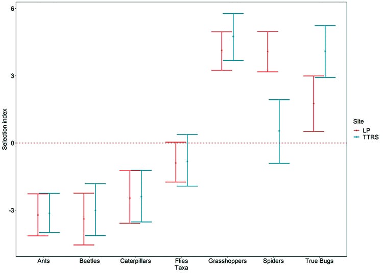
Bobwhite broods consumed 16 taxonomic orders of arthropods, including mites and ticks, which may have been consumed either during preening or as a secondary prey (prey consumed by prey, or parasites of prey). The most frequently consumed groups at both sites were grasshoppers, spiders, and true bugs such as stink bugs, with grasshoppers occurring in over 85% of all samples. We found that bobwhite broods consumed grasshoppers, spiders and true bugs more than expected based on arthropod abundance, whereas they consumed ants, beetles, caterpillars, and flies less than expected (Figure 1).
Figure 1. Selection of arthropods by bobwhite broods at Livingston Place and Tall Timbers. A selection index above zero indicates that the arthropod group was consumed more than expected while values below zero indicate the group was consumed less than expected.
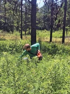
Collecting insect samples.
If consuming certain arthropod groups provides a benefit to bobwhite chicks, such as increased growth rate, a management objective should be to increase the abundance and accessibility of those groups. We therefore sampled arthropod abundance bi-monthly throughout the breeding season on Tall Timbers and Livingston Place. Sampling occurred in burned and unburned uplands, fallow fields and planted agricultural crops (i.e., corn, cotton, grain sorghum, and soybeans), using pitfall traps and suction sampling. Five preexisting fields were split into equal parts and planted in corn, grain sorghum and soybeans, resulting in 15 fields of similar size (~3 acres).
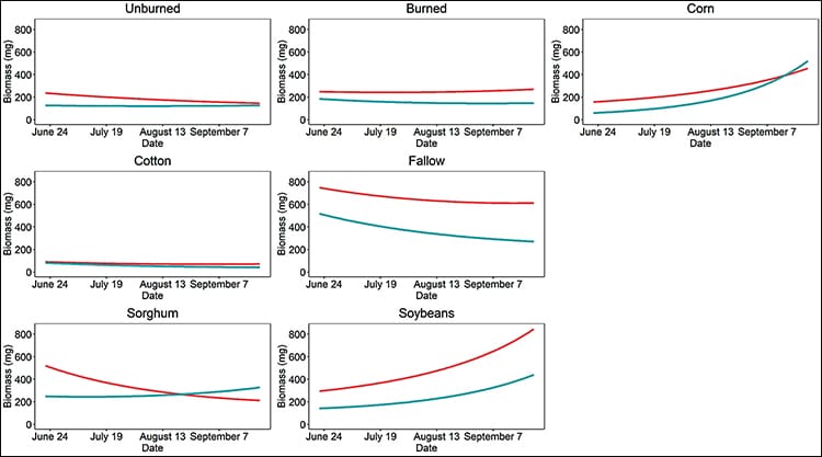
We collected nearly 35,000 individual arthropods between the two sites. The arthropod groups consumed more than expected (grasshoppers, spiders and true bugs), were positively affected by recently burned uplands, burned between March and April, fallow fields, sorghum and soybeans, and negatively affected by corn and cotton (Figure 2). We found similar results for the arthropod groups consumed less than expected (ants, beetles, caterpillars, and flies). In addition, we found that the biomass of both sets of arthropods increased within corn and soybean fields as the breeding season progressed (Figure 2).
Figure 2. Predicted biomass of arthropods consumed more than expected (blue) and less than expected (red) within six landcovers throughout the 2018 breeding season at Tall Timbers and Livingston Place.
The development of Roundup Ready crops has resulted in clean agricultural fields, especially early in the summer. At the time of our study, Roundup Ready grain sorghum had not hit the market, thus, our results are applicable to traditional grain sorghum. It is important to note that the corn, grain sorghum, and soybeans planted for this project did not receive intense weed control. Weed growth within the crop fields likely attributed to the increased biomass over time.
We used the probability of broods consuming arthropods as a metric for accessibility. We found that the probability of consuming grasshoppers, spiders, and true bugs remained relatively high when foraging areas of radio-tagged broods consisted of 25% of either burned uplands, fallow fields, sorghum, or soybean fields. Consumption of these same groups drastically declined in foraging ranges consisting of 25% corn fields (Figure 3). We also found that consumption of the other arthropod groups was worse in foraging areas that consisted of corn fields compared to other field treatments (Figure 4). The consistent finding that corn fields negatively affected the probability of arthropods being consumed suggests that corn fields limit the diet choices of bobwhite broods.
Figure 3. Probability of arthropod groups consumed more than expected occurring in the diet of northern bobwhite broods based on foraging ranges consisting of 25% of the land cover at Tall Timbers and Livingston Place.
Figure 4. Probability of arthropod groups consumed less than expected occurring in the diet of northern bobwhite broods based on foraging ranges consisting of 25% of the land cover at Tall Timbers and Livingston Place.
The objective of this study was to better understand how various agricultural crops affect arthropod abundance and brood diet to improve our knowledge on the best management practices for existing fields. We found that keeping fields fallow was best due to a greater biomass of all arthropod groups through mid-August, when ~80% of broods will have hatched. However, we recognize there are numerous economic considerations when managing working lands for bobwhite. If you need to farm, consider crop type.
For example, we found grain sorghum to be the most beneficial crop to quail based on arthropod abundance and accessibility. However, the development of Roundup Ready grain sorghum may reduce the benefits during the early breeding season. Cotton had the lowest biomass of arthropods throughout the breeding season and, anecdotally, receives little use by radio-tagged birds at Livingston Place.
However, options to improve arthropod availability within croplands might include creating fallow field borders or fallow strips running through larger fields.
Corn and sorghum are common crops found on managed quail lands.
Thank you for submitting a job post request
Say NO to a New Toll Road in Jefferson County
The M-CORES program, which includes the proposed Suncoast Connector Toll Road in Jefferson County, passed through the Florida Legislature at breakneck speed with little review or analysis. Tall Timbers has a number of concerns given the potential for significant and wide spread impacts. These include fragmenting public and private conservation lands, robbing business from Main Street Monticello, impacting our rivers and other water resources, and making prescribed fire more difficult and costly.
Join us in asking the Jefferson County Board of County Commissioners to OPPOSE the Suncoast Connector toll road and its path through Jefferson County.
Take action now with our easy email form.
Send an email to all five Jefferson County Board of County Commissioners with one click!
Burn prioritization modeling seminars and fire modeling tools are supported by Wildland Fire Science to train managers in the important planning stages of prescribed fires.
Educating and guiding the next generation of fire researchers and managers is a key goal of Wildland Fire Science and a resource for testing new ideas in fire research.
Tall Timbers hosts the premier fire technology transfer organization—the Southern Fire Exchange. This JFSP funded effort helps connect research to management through webinars, workshops, and support of the Prescribed Fire Science Consortium.
Working with partners in the Prescribed Fire Science Consortium, the program is building nexgen 3-D fuel beds using terrestrial LiDAR and novel sampling techniques to power new fire behavior models for prescribed fire managers. This work links to Tall Timbers work in wildlife habitat usage and ecological forestry.
The Longleaf Legacy landscape prescribed fire burn team arm of Wildland Fire Science works directly with landowners and partners to effectively put fire on the ground and promote prescribed fire throughout the region.
Tall Timbers is leading an effort to map fire regimes at the landscape scale. Staff work with numerous agencies to evaluate fire records and satellite imagery to build this critical conservation database. https://skfb.ly/6DqOY
Tall Timbers hosts the Prescribed Fire Science Consortium, a national network of researchers and managers who promote integrated research and management to advance next generation tools for fire practitioners. https://arcg.is/1DSjDT
We are linking physics and field observations to understand the fluid dynamics of fire behavior surface fire regimes. Our work combines field observations using advanced thermal imaging techniques, laboratory studies, and coupled fire-atmospheric modeling to help managers improve outcomes of managed fire regimes.
Selected Publications authored by Wildland Fire Science staff.
Staff and researchers support Federal fire training by serving as a cadre for NWCG training courses, ranging from basic wildland fire to advanced fire effects.
(PFTC) specializes in training fire fighters the principles and techniques of prescribed fire through practical hands-on experience. https://www.fws.gov/fire/pftc/
Private land owners are the largest source of prescribed fire in the country. These land owners and the culture of fire that was maintained by them during decades of suppression are a part of why Tall Timbers is a world-wide center for prescribed fire science. Workshops and fire training are a critical focus of the Longleaf Legacy Landscape Burn Team and our support of the Georgia Forestry Commission Prescribed Fire Center in Marion County.
The conserved lands of the Greater Red Hills region are found on working, income-producing properties that support agriculture, forestry, and recreational hunting. These properties contribute $272 million annually to local economies and support 2,300 jobs. [link to Planning & Advocacy section] The landowners’ strong stewardship ethic preserves their working lands while replenishing drinking water supplies, protecting water quality, and providing wildlife habitat for dozens of rare and endangered species. Tall Timbers’ conservation easements on these working properties encourage landowners to retain their traditional livelihood by keeping farms in family ownership.
Home to world-class wild quail populations, the Greater Red Hills region contains the largest concentration of gamebird preserves in the United States. These preserves also support the largest community of Red-cockaded woodpeckers on private lands. Indicators of high quality habitat found here include the gopher tortoise, Bachman’s sparrow, fox squirrel, and many amphibians. Tall Timbers’ conservation easements identify and protect the critical habitats of these species.
The region also boasts outstanding aquatic resources. Large river systems, like the Flint/Apalachicola, Ochlockonee, and Aucilla, flow from Georgia and feed into the Gulf of Mexico to support some of the world’s most productive estuaries. Large disappearing sinkhole lakes, like Iamonia, Miccosukee, and Jackson, provide habitat for an array of aquatic species and migratory birds. Tall Timbers’ conservation easements protect these vital watersheds and wetlands that are the lifeblood for the ecological health of the region.
Once dominated by longleaf pine, our pine woodlands support abundant wildlife and local economies. These forests need prescribed fire to stay healthy. Herbert L. Stoddard and his associates Ed and Roy Komarek were pioneers in this emerging scientific field during the mid-20th century. Tall Timbers continues that legacy with applied research on prescribed fire and land management. Today, there is a tremendous need to expand prescribed fire use beyond the Red Hills to ensure ecosystem health and reduce wildfire risk. Additionally, Tall Timbers uses conservation easements to permanently protect private woodlands while balancing the need for economic return from selective timbering.


 Covey calls can be conducted using a point count method or a plot method.