The third year of a study by Tall Timbers and other partners hopes to capture data about movement patterns of mourning doves in the Red Hills and Albany regions of Georgia and Florida.
During the 2022-23 hunting season, the initial year of the study done in collaboration with several private properties in the region and the University of Georgia, 24 bands were reported back to Tall Timbers out of 497 put onto birds, a 5% return.
Out of the 24 harvested banded birds, 17 were harvested on the same site in which they were banded and six were harvested on different sites, two of which were sites not involved in the banding last summer.
The furthest bird movement documented was a bird banded in the Red Hills which was harvested in Palm Beach County in early January.
We are again asking everyone to keep a close eye out for leg bands on any of your harvested birds during dove season.
Reporting your harvested banded birds directly to the USGS Bird Banding Lab (BBL) and Tall Timbers will allow us to better understand the ecology and demographics of doves in this region.
After reporting bands to the the BBL, please send an email to Dwayne Elmore (delmore@talltimbers.org) at Tall Timbers including the band number, the date you harvested the bird, and the location where you harvested the birds (preferably a set of GPS coordinates, if possible). Harvest location coordinates will allow us to better understand the distance the dove traveled from the location it was banded to the location it was harvested.
Have no fear, we will not release this more detailed location information and will only pass on the harvest state for the official Bird Banding Laboratory data.
For more information about the scope of the project, please see the following article originally published in our 2022 edition of Quail Call. Thank you in advance for the submission of any banded birds and good luck this year!
The 2024-25 mourning dove seasons for both Georgia and Florida are listed below. Check your state’s laws for all hunting season dates.
Georgia: September 6th – October 12th, November 22nd – 30th, and December 19th – January 31st
Florida: September 27th – October 19th, November 8th – 30th, and December 19th – January 31st
Mourning Doves: The Other Highly Prized Bird
By Nicolas Lusson, Lead Game Bird Technician, originally published in the Summer 2022 edition of Quail Call.
Dove hunting is an important cultural and economic activity in the Red Hills, with some fields in existence for over a hundred years. However, over the past decade dove use of properties has varied dramatically. Some properties now have so few doves at their managed fields that hunting no longer occurs, whereas other properties harvest several hundred to thousands of doves in a single season.
Most hunting and harvest in the Red Hills and Albany regions occur during the early phase of the dove season, which raises concern about the effect of harvest on local populations.
In addition to high variability of field use, there has been an overall observed decline in dove harvest across many properties in the region. Most hunting and harvest in the Red Hills and Albany regions occur during the early phase of the dove season, which raises concern about the effect of harvest on local populations.
There is also concern that the amount of dove fields in the area is causing the local population to disperse more widely across the landscape, reducing the apparent dove population. Several property managers and our research group have instigated a study, along with Florida Fish and Wildlife Conservation Commission and Georgia Department of Natural Resources, to begin to explore these potential issues. We are interested in examining the movement patterns of mourning doves within and among the properties of the Red Hills and Albany regions of Georgia and Florida.
Also, we aim to calculate the harvest rates to compare with statewide rates in Georgia and Florida. Our primary approach for measuring these processes is banding a lot of doves relying on you dead-eye shooters to “capture” some of them! All we ask is that you report the band numbers to us!
Banding provides data on the geographical and temporal distribution of the dove harvest, origins of birds harvested, mortality, survival, longevity, differential vulnerability of age and sex classes to shooting, and other information useful to managing the species.
To monitor harvest rates, many states, such as Georgia and Florida, collaborate with the United States Fish and Wildlife Service (USFWS) to band doves every year. Breeding Bird Survey (BBS) data reflects that dove populations have been growing in the region. However, recent anecdotal evidence based on banding data suggests a decline in dove populations or an increase in recovery rates. Finer scale information about the relationship between hunter harvest rates and dove populations would inform larger scale population processes and management.
In addition to information about the harvest rates, banding can be used to study movements. Finally, we can explore landscape features and management actions that lead to greater success in dove hunting.
In the low-lying areas among the longleaf pines, a small group of biologists search for one of America’s most secretive birds. As footfalls disturb damp grasses, a small sparrow emerges and flies a few yards away before dropping suddenly back into the grass to run. The biologists set up their nets to catch the small migrant from the north, the Henslow’s Sparrow.
The Stoddard Lab is no stranger to these grass-walking sparrows. For many years, the lab has studied Bachman’s Sparrows and Grasshopper Sparrows from Tallahassee, Florida to Bainbridge, Georgia. The common theme among all these sparrows is their connection to the vegetation structure — the Henslow’s Sparrow is no different.
The Red Hills region of Georgia and Florida harbors many Henslow’s in the winter months due to the vast amounts of fire-maintained pinelands reminiscent of their summer breeding grounds. Similar to our year-round residents, such as Northern Bobwhites and Bachman’s Sparrows, there’s a particular association with fire and the habitat that they prefer.
Visiting scientist, Erik Johnson, joined with the Stoddard Bird Lab to assist in the annual Henslow’s Sparrow captures. Back in 2004, he worked on Henslow’s Sparrows in Louisiana as part of his master’s work at Louisiana State University and he now serves as Director of Conservation Science at Audubon Delta.
“I found that after a growing season burn, the wintering Henslow’s density was highest. Then each year after that burn, the Henslow’s density decreased by about half, until it essentially reached zero after about three years,” Johnson said.
Visiting researcher Erik Johnson holds a Henslow’s Sparrow after banding it, measuring it, and collecting a small blood sample. Volunteer Jeff Shenot excitedly photographed the colorful little bird.
In our region, one of the highest capture rates occurred in winter following a mid-April burn. Fortunately, due to regular use of prescribed fire, we don’t have many properties that allow a 3-year rough to develop.
The reason for this trend is simple. Next time you’re in the pine savannah, try shuffling your feet to move around. One year after a burn, this is very easy to do. So called ‘bunch grasses’ like wiregrass leave spaces of bare soil between clumps of grass making a small scale “canopy road” to walk through. Conversely, the three-year post-burn environment is like a jungle of matted vegetation. You might be only able to make it a foot or so before tripping over a briar or having to resort to excessive force to plow through the vegetation.
So far, the Stoddard Bird Lab has captured almost 30 of these elusive sparrows this year. Finding these birds requires multiple individuals to flush birds up and into our nets, a technique the bird lab has used many times on other grass-walking sparrows.
This year, the Stoddard Bird Lab is collaborating with master’s student Emily Nastase of North Carolina State University to collect blood samples from the Henslow’s we catch. The samples will help us understand where our winter sparrows come from and how they are related to Henslow’s found in other parts of the country.
The range of the Henslow’s Sparrow spans from New York to Nebraska, and it is yet unknown where the Red Hills migrants spend their summers.
The software developed by the federal government to report records of bird banding flashes a warning each time we enter the bird’s name: “Not common in your area.” We’ve captured over 160 individuals over the years, including nearly 50 birds in a small, 10-acre parcel we sample repeatedly.
Our ties to the north could weave a complex conservation story that is yet unknown. But thanks to our collaborations with bright minds such as Johnson and Nastase, we can hope to understand more about the birds that call our pinelands home.
This past summer, Tall Timbers Biological Monitoring Coordinator, Kim Sash, and Technician Deanna Riente initiated a gopher tortoise disease study. Sash and Riente along with Kendra Rich, a University of Tennessee veterinary student, trapped gopher tortoises on five properties in the Red Hills region. Considered a threatened species in both Florida and Georgia the project focused on obtaining samples from tortoises to test them for diseases that may contribute to their population decline.
The terrestrial tortoise is found in upland habitats with suitable soils in Florida and south Georgia, but its numbers are declining due to a number of reasons, including habitat loss and disease. A keystone species, gopher tortoises dig burrows that are also used by more than 360 other species, including amphibians, other reptiles, rodents, and a whole suite of insects.
Due to the biological importance of the gopher tortoise and its burrows, Sash remarks, “This research is important because the Red Hills region supports the largest gopher tortoise population on private lands.”
A gopher tortoise burrow.
On these private properties, Sash and Riente scouted for gopher tortoise burrows and flagged the burrows as potential trapping sites.
The flagged burrows were then inspected with a gopher tortoise burrow scope, which is a camera and light mounted to a long cable and attached to a video monitor. If a tortoise is present in the burrow, a trap is placed at the burrow entrance. The traps are covered to shield the tortoise from the sun, and marked on an app to keep track of where each was located. The traps were checked multiple times per day to see if a gopher tortoise was captured.
A covered gopher tortoise trap.
Once trapped, Sash and Riente take the gopher tortoises back to the Tall Timbers campus to collect oral and cloacal swabs and a blood sample. They also take measurements (length, sex, weight) of each tortoise and record this information.
During the course of the study some gopher tortoises were recaptured to see if season plays a role in disease abundance. Therefore, in order to recognize individuals Sash and Riente use PIT (Passive Integrated Transponder) tags to give each individual and unique number. According to Sash, “It’s the same as microchipping your pet.” They use a PIT tag reader to scan the tortoise and determine if they’ve trapped the tortoise previously. If they haven’t, they’ll tag it and be able to identify it in the future.
Here, you can see where each gopher tortoise trap is located on the property.
Sash explains, “We can use this information to understand the general health of this large and ecologically important population.” Samples are currently at the University of Illinois where they will be analyzed for multiple diseases.
As of November 2022, Sash and Riente trapped 110 tortoises, 49 from Georgia and 61 in Florida. Their data can help them further research on gopher tortoises in the region. According to Sash, “As gopher tortoises are relocated around the state due to development, we hope to use this data to see if disease is transmitted from resident or relocated tortoises through the rest of the population and what impacts that will have on gopher tortoise demographics.”
By Clay Sisson, Albany Quail Project Director and Extension Coordinator and Karen Cummins, Geospatial Database Administrator
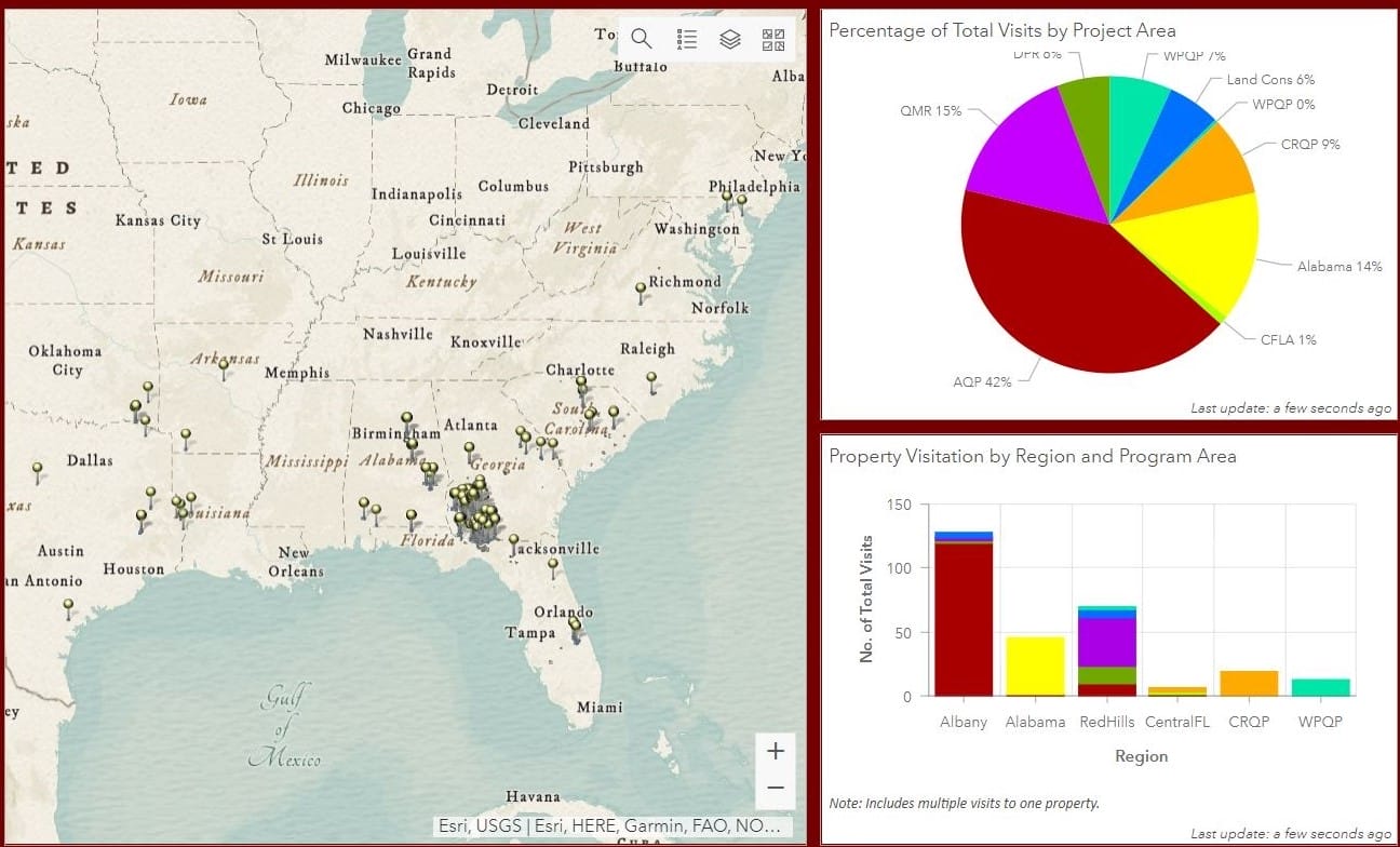
The Tall Timbers’ Game Bird Program needed an efficient way to track field visits on hunting properties both by program area and regionally to help maintain our partnerships with land managers and owners. The Tall Timbers Geospatial Lab had just the right tools for this undertaking. The Geospatial Lab developed an intuitive mobile app solution, so that the Game Bird Program staff can enter basic information regarding their visit, even in remote locations.
One of the benefits of the mobile app is that the user can just place a pinpoint on their location and the app will automatically generate the current data, name of property, as well as the region, so they can spend more time with the landowner and less time filling out forms. The data from the mobile app is then displayed in a ‘Regional Extension Activity Tracker Dashboard’ that summarizes their data into charts and lists, as well as an online map.
A section of the new app dashboard displaying a map of properties visited and the number of visits by region.
On the map, it’s incredible to see the range that the Game Bird Program covers – from Texas to Maryland, and down to Central Florida, as well as the density of coverage in the Red Hills and Albany regions. As of November, there have been 311 property visits in 2022 by Tall Timbers game bird biologists.
Clay Sisson, the Albany Quail Project Director and Extension Coordinator at Tall Timbers, can now just look at the Activity Tracker Dashboard on his phone and quickly assess if there’s been a recent property visit, so communication with landowners is much more efficient. The Game Bird Program can now easily assess where they haven’t visited as well, so they can touch base with these landowners and see if they need assistance.
Chart depicting property visits by Region and Program Area.
There’s also an interesting friendly competition that’s developed among the Game Bird staff members on who can visit the most properties. This is a great example of how the Geospatial Lab has supported other Tall Timbers’ programs and made them more efficient.
By Kevin Robertson, PhD and Cinnamon Dixon, Fire Ecology Lab, originally published in the Summer 2022 edition of Quail Call.
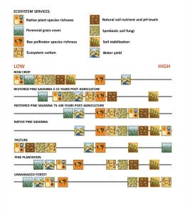
The term “ecosystem services” has gotten a lot of buzz in recent years. They are basically products or processes provided by natural lands that benefit humans. It follows that hunting itself is an ecosystem service. However, management for northern bobwhite, especially the use of frequent prescribed fire, can provide many more benefits than just good hunting, which is important for us and our community to appreciate. The Tall Timbers Fire Ecology Program recently published a paper measuring various ecosystem services provided by different land uses in the Red Hills Region.
Given that much of the region is covered with old-field pinelands managed for northern bobwhite, we were particularly interested in how time since abandonment of agriculture followed by application of frequent prescribed fire would influence various ecosystem services. We chose locations with different times since fields were abandoned and burning started using old aerial photographs and maps, categorizing locations into age groups ranging from 5-10 years up to 75-100 years post-agriculture, and then measured many aspects of the plants, soil, and soil fungi and bacteria. We were also interested in how these old-field pinelands compared to native longleaf pine-wiregrass communities as well as current row-crop agriculture, pine plantations, and unmanaged (long unburned) pine-hardwood forests.
We chose locations with different times since fields were abandoned and burning started using old aerial photographs and maps, categorizing locations into age groups ranging from 5-10 years up to 75-100 years post-agriculture, and then measured many aspects of the plants, soil, and soil fungi and bacteria.
The study was replicated in four different areas — in and around Tall Timbers, Livingston Place, Pebble Hill Plantation, and Avalon Plantation — thanks to the hospitality of these and many other private landowners. Our results showed that with increasing time since agriculture there is an increase in perennial grass cover, native plant biodiversity, soil carbon, total ecosystem carbon, and mycorrhizal soil fungi, and a decrease in soil plant pathogens, water runoff, and soil erosion. Soil mineral nutrients including phosphorus, calcium, magnesium, and potassium also decreased toward levels closer to native pine communities, which is helpful for minimizing off-site and weedy plants and decreasing pollution from runoff. Frequently burned old-field and native pinelands also fared well compared to other common land uses.
Naturally, row-crop agriculture produces the most food and fodder, pasture produces the most forage, and pine plantations produce the most timber. However, frequently burned pinelands showed lower losses of water to transpiration, higher water infiltration, and higher bee pollinator diversity than pine plantations and unmanaged forests. They also had higher total ecosystem carbon and less runoff and sedimentation than pastures and row crops. Older old-fields and native pinelands had the overall highest native plant diversity which translates to diversity of insects and the vertebrate animals that depend on them.
They also had the healthiest soil in terms of C:N ratio, lowest bulk density, most natural levels of mineral nutrients and nitrogen, and symbiotic fungi that help plants grow. These results highlight the many benefits provided by quail management, especially use of frequent prescribed fire and timber management to maintain an open canopy, on mostly post-agricultural landscapes like the Red Hills. However, it also follows that many of the benefits accumulated over time are lost by intensive soil disturbance that more or less returns the soil and vegetation to agricultural conditions and resets the successional clock.
Given that native pine savannas generally had the highest levels of most ecosystem services, prioritizing them for protection from intensive soil disturbance is a good idea. In summary, frequent fire on oldfield and native pinelands provides a wide range of services helpful to both landowners and the broader community, although some diversity of land use is necessary for providing all the benefits we humans need to thrive.
The M-CORES program, which includes the proposed Suncoast Connector Toll Road in Jefferson County, passed through the Florida Legislature at breakneck speed with little review or analysis. Tall Timbers has a number of concerns given the potential for significant and wide spread impacts. These include fragmenting public and private conservation lands, robbing business from Main Street Monticello, impacting our rivers and other water resources, and making prescribed fire more difficult and costly.
Join us in asking the Jefferson County Board of County Commissioners to OPPOSE the Suncoast Connector toll road and its path through Jefferson County.
Take action now with our easy email form.
Send an email to all five Jefferson County Board of County Commissioners with one click!
Burn prioritization modeling seminars and fire modeling tools are supported by Wildland Fire Science to train managers in the important planning stages of prescribed fires.
Educating and guiding the next generation of fire researchers and managers is a key goal of Wildland Fire Science and a resource for testing new ideas in fire research.
Tall Timbers hosts the premier fire technology transfer organization—the Southern Fire Exchange. This JFSP funded effort helps connect research to management through webinars, workshops, and support of the Prescribed Fire Science Consortium.
Working with partners in the Prescribed Fire Science Consortium, the program is building nexgen 3-D fuel beds using terrestrial LiDAR and novel sampling techniques to power new fire behavior models for prescribed fire managers. This work links to Tall Timbers work in wildlife habitat usage and ecological forestry.
The Longleaf Legacy landscape prescribed fire burn team arm of Wildland Fire Science works directly with landowners and partners to effectively put fire on the ground and promote prescribed fire throughout the region.
Tall Timbers is leading an effort to map fire regimes at the landscape scale. Staff work with numerous agencies to evaluate fire records and satellite imagery to build this critical conservation database. https://skfb.ly/6DqOY
Tall Timbers hosts the Prescribed Fire Science Consortium, a national network of researchers and managers who promote integrated research and management to advance next generation tools for fire practitioners. https://arcg.is/1DSjDT
We are linking physics and field observations to understand the fluid dynamics of fire behavior surface fire regimes. Our work combines field observations using advanced thermal imaging techniques, laboratory studies, and coupled fire-atmospheric modeling to help managers improve outcomes of managed fire regimes.
Selected Publications authored by Wildland Fire Science staff.
Staff and researchers support Federal fire training by serving as a cadre for NWCG training courses, ranging from basic wildland fire to advanced fire effects.
(PFTC) specializes in training fire fighters the principles and techniques of prescribed fire through practical hands-on experience. https://www.fws.gov/fire/pftc/
Private land owners are the largest source of prescribed fire in the country. These land owners and the culture of fire that was maintained by them during decades of suppression are a part of why Tall Timbers is a world-wide center for prescribed fire science. Workshops and fire training are a critical focus of the Longleaf Legacy Landscape Burn Team and our support of the Georgia Forestry Commission Prescribed Fire Center in Marion County.
The conserved lands of the Greater Red Hills region are found on working, income-producing properties that support agriculture, forestry, and recreational hunting. These properties contribute $272 million annually to local economies and support 2,300 jobs. [link to Planning & Advocacy section] The landowners’ strong stewardship ethic preserves their working lands while replenishing drinking water supplies, protecting water quality, and providing wildlife habitat for dozens of rare and endangered species. Tall Timbers’ conservation easements on these working properties encourage landowners to retain their traditional livelihood by keeping farms in family ownership.
Home to world-class wild quail populations, the Greater Red Hills region contains the largest concentration of gamebird preserves in the United States. These preserves also support the largest community of Red-cockaded woodpeckers on private lands. Indicators of high quality habitat found here include the gopher tortoise, Bachman’s sparrow, fox squirrel, and many amphibians. Tall Timbers’ conservation easements identify and protect the critical habitats of these species.
The region also boasts outstanding aquatic resources. Large river systems, like the Flint/Apalachicola, Ochlockonee, and Aucilla, flow from Georgia and feed into the Gulf of Mexico to support some of the world’s most productive estuaries. Large disappearing sinkhole lakes, like Iamonia, Miccosukee, and Jackson, provide habitat for an array of aquatic species and migratory birds. Tall Timbers’ conservation easements protect these vital watersheds and wetlands that are the lifeblood for the ecological health of the region.
Once dominated by longleaf pine, our pine woodlands support abundant wildlife and local economies. These forests need prescribed fire to stay healthy. Herbert L. Stoddard and his associates Ed and Roy Komarek were pioneers in this emerging scientific field during the mid-20th century. Tall Timbers continues that legacy with applied research on prescribed fire and land management. Today, there is a tremendous need to expand prescribed fire use beyond the Red Hills to ensure ecosystem health and reduce wildfire risk. Additionally, Tall Timbers uses conservation easements to permanently protect private woodlands while balancing the need for economic return from selective timbering.