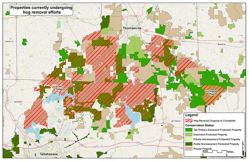
In 2019, Tall Timbers partnered with the USDA Feral Swine Eradication and Control Pilot Program (FSCP). The purpose of the program, funded in the 2018 Farm Bill, is to respond to the threat feral swine pose to agriculture, native ecosystems, and human and animal health. Tall Timbers’ project includes the Red Hills region from Tallahassee, Florida to Thomasville, Georgia, shouldered by the Ochlockonee and Aucilla rivers.
With over 82% of Red Hills landowners participating the concentrated effort, the project has had a lot of success. As of July 2021, moving from the Ochlockonee River eastward, there have been 1,877 hogs removed. The project funds USDA’s Wildlife Services employees to apply their trapping expertise on private lands. This concerted effort has taken the burden off landowners in the time consuming and frustrating process of trapping feral swine.
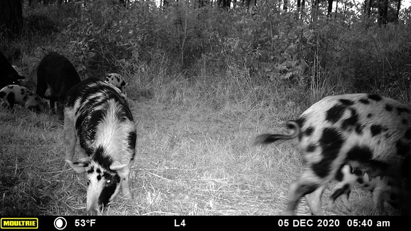
Feral swine are not only destructive, but also spread disease. Wildlife Services professionals are disease testing a portion of the hogs captured. These blood draws test for both pseudorabies virus (PRV) and swine brucellosis. Of the 58 hogs tested for pseudorabies, 22% returned positive results. These results are typical with what has been documented in other populations of feral swine. PRV is transmitted primarily through direct animal-to-animal contact, but it can also spread indirectly through contaminated boots, knives, equipment, etc. PRV can also affect dogs, cattle, cats, sheep, and goats – there is no treatment, but antibiotics can help with secondary bacterial infections. Of the 56 hogs tested for swine brucellosis, 9% returned positive results. This disease can be contracted by people and is transmitted through bodily fluids and/or by ingesting infected tissues. Protective gloves and washing after handling feral hogs are critical to limit the spread of these diseases.
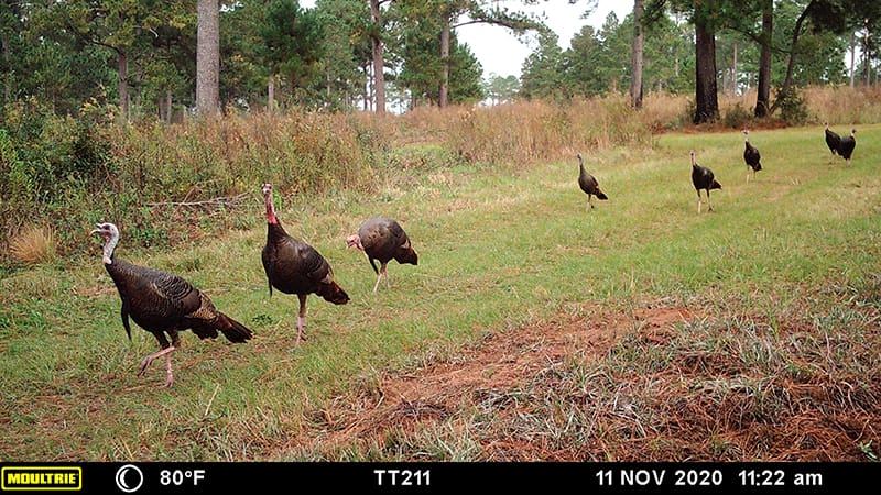
A concurrent project to the trapping effort is monitoring its effectiveness. Through the USDA grant, Tall Timbers is funding University of Georgia Master’s student, Kelsey Hoskins (advised by Dr. Mike Mengak). Kelsey’s project focuses on the before and after effects of the removal of feral swine on the landscape. This includes effects to native wildlife and habitats and water quality before and after the removal of feral hogs on a property. With over 150 wildlife cameras across the landscape, Kelsey’s data may show a displacement of native wildlife on the landscape while feral hogs are present, and the return of native wildlife, once feral hogs are removed. Thus far, Kelsey has collected over 291,764 images. Kelsey is also documenting habitat damage due to feral hogs, and that information is also collected via landowner surveys conducted by Tall Timbers.
With over 150 wildlife cameras across the landscape, Kelsey’s data may show a displacement of native wildlife on the landscape while feral hogs are present, and the return of native wildlife, once feral hogs are removed. Thus far, Kelsey has collected over 291,764 images.
Beginning this month, Tall Timbers technician Chris Terrazas, with assistance from Wildlife Services, will be putting GPS collars on feral swine. This project will transition to a graduate project for Chris to study how these feral hogs are using the landscape, including how far they travel, routes of travel, and optimal foraging and resting habitats. This information will be helpful for future control of feral hogs in the Red Hills. We look forward to sharing results of this project in the future.
Currently, the FSCP is slated to wrap up in September 2023. Tall Timbers hopes that the Farm Bill will renew this successful project and we will be able to expand to areas outside of the Red Hills in order to assist more private landowners. Tall Timbers will continue efforts to include feral hog control in future Farm Bills, and encourages landowners to talk to their elected officials for continued support of this project.
Tall Timbers Helping Landowners Manage Land in Florida
By Peter Kleinhenz, Aucilla River Coalition Coordinator
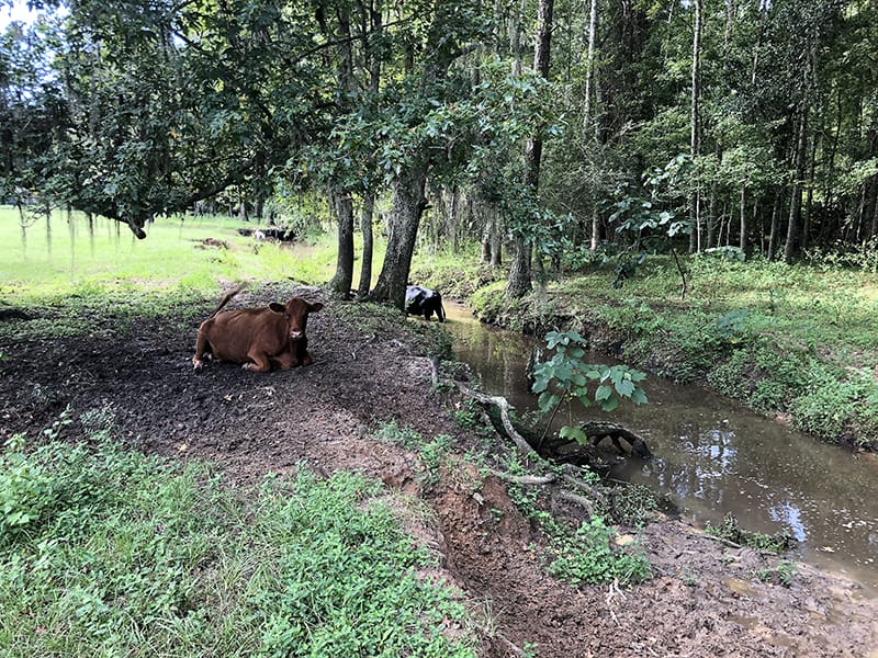
When you work in watershed conservation, there are few things that get you down like seeing major, negative impacts to waterways right before your eyes. This was the case last week when Tall Timbers Field Biologist, Becc Armstrong, and I were out on a property visit in Jefferson County, Florida. We were looking down at a stream coursing through mature forest at the edge of a cattle pasture. Dozens of cows were standing in the creek, defecating in the scum-encrusted water and sloshing about on the muddy bank. The creek, as it flowed through this particular property, was trashed.
Cows rest and wade in a stream, creating significant water quality issues for both this stream and for the Aucilla River, which it ultimately flows into. Photo by Peter Kleinhenz.
Sad as this sight was, we were there to help. Becc and I are both part of a team at Tall Timbers that, along with Conservation Program Liaison, Tyler Macmillan, are working to help landowners improve their properties for wildlife and water quality. The three of us are funded by the Natural Resources Conservation Service’s Regional Conservation Partnership Program (NRCS-RCPP). The pot of money that provides our salaries also reimburses select landowners for 75% of their land management costs, if they get involved with the program. In the case of the nasty creek described above, this reimbursement would help to offset the cost of fencing the cattle out of the stream and associated wetlands on the property.
Tyler Macmillan tours a property with a landowner that has applied for RCPP funding. Photo by Becc Armstrong.
The Little Aucilla River is one of many waterways that will directly benefit from activities conducted through this project. Photo by Peter Kleinhenz.
Our NRCS-RCPP project, “Red Hills to the Coast, Connecting Land and Water,” covers the St. Marks and Aucilla River watersheds in both Florida and Georgia. From July to September, landowners throughout the Florida portion of these watersheds got in touch with the RCPP team about getting land management activities implemented on their properties. These are landowners that run the gamut of financial resources, age, knowledge, and property size. However, one common thread exists between all of them: an interest in making their property more ecologically-friendly.
Our small team works with the landowners from beginning to end. First, we help landowners fill out the correct forms to apply for the program. Next, we visit properties with the landowners to understand their wishes for the property and to assess what land management practices are most needed. From these visits, we develop maps and lists of potential practices to administer. After the application period ends, applications get ranked based on questions about natural resource concerns, the potential for land management to benefit listed species, acreage to be treated, and more.
The landowners fortunate enough to get selected for funding enter into contracts with NRCS, either to hire contractors or to do the management work themselves, and then get reimbursed for 75% of their cost based on NRCS rates for each type of management activity. If this all sounds complex, that’s because it is. But this program, at the end of the day, gets the work done and is investing hundreds of thousands of dollars each year over the next five years to do just that.
Fire-suppressed longleaf pine forest will benefit greatly from prescribed burning implemented by this RCPP project. Photo by Tyler Macmillan.
In our first year, nearly 30 Florida landowners representing over 7,000 acres applied for assistance through the Tall Timbers RCPP program. It’s unlikely that we will have enough funding to help all of them, but we will accomplish as much as we can. Executing these land management activities will benefit native species, improve water quality and quantity in the watersheds, and reduce public safety threats by reducing fuel loads using prescribed fire. For many landowners, involvement with this program will get the ball rolling on land management that can continue indefinitely.
The wild thing about the Tall Timbers RCPP project is that this land management component is just one piece of a larger project that includes everything from oyster restoration, to purchased conservation easements, to an economic impact study, to a social survey to understand attitudes about conservation in these watersheds. In other words, our team is busy, but we are motivated by the fact that we are helping to improve and conserve properties that, in many cases, would not be improved or conserved without this program’s help. That feels good.
The Western Pineywoods Quail Program established to restore bobwhite populations to east Texas
By Brad Kupecka, Western Game Bird Program Director
Texas is a well-known destination for quail hunters across the globe, but the backdrop of a Texas covey rise doesn’t often portray a fire managed pine savannah. While quail populations are abundant in the semi-arid regions of the Rolling Plains and south Texas, very little research or management attention has been afforded to the forested region of the state—at least not in the past several decades. As a matter of fact, the “fire bird” has been all but extirpated from the Pineywoods of the Lone Star State, where past populations would rival or surpass those in the west.
With growing angst from Texas quail hunters to restore bobwhite populations to the eastern region of the state, Tall Timbers was strongly encouraged to create a program in east Texas by Mr. Chuck Ribelin, an avid quail hunter and advocate, who appreciates Tall Timbers’ proactive approach to quail management. Thanks to Mr. Ribelin’s generous financial support, ideas, and encouragement, Tall Timbers’ entry into east Texas, and surrounding areas, became a reality earlier this year. The Western Pineywoods Quail Program (WPQP) was established in late 2020, and is the newest regional addition to the Game Bird Program at Tall Timbers, with the goal of restoring bobwhite populations to the Pineywoods ecoregion of Texas and surrounding areas, using scientifically-based management and outreach.
Already, interest and support for our newest program has been fantastic and greatly appreciated. We’ve received funds from several private donors such as Park Cities Quail Coalition (PCQC) in Dallas, and most recently, Texas Parks and Wildlife. Collectively, these funds are supporting a new biologist position and our first research project on private lands. Knowing that time and consistency are needed for success in quail management, Tall Timbers has secured over half of a $4 million endowment campaign to secure the program’s positions in perpetuity, ensuring this region will always have a core of bobwhite research and stakeholder guidance.
An inaugural research project near Livingston, Texas to restore bobwhite habitat and populations was hatched last year, with the gracious support of the Gordy family of Houston. This project has an audacious vision to restore over 8,000 acres of habitat with the implementation of prescribed fire, timber and brood field management, supplemental feeding, and predator control. Tall Timbers is also providing technical support to neighboring properties to increase the footprint of this project. Bobwhite populations in the Pineywoods are sparse, and not expected to responded to habitat management alone.
Once high-quality habitat is restored, the Game Bird Program will use translocation as a tool to augment the population. From there, many questions are set to be answered regarding the ecology of bobwhite in this region. Fortunately, Tall Timbers’ long history of quail research and management in the Red Hills provides a good foundation for baseline management recommendations. With time, the program seeks to develop collaborative efforts on both private and public lands across the Pineywoods, which hosts over half a million acres of Texas’ public lands. Past and successful collaborations on state and federal lands in Florida and Georgia, provide good blueprints to replicate the efforts.
For more information about the Western Pineywoods Quail Program research, habitat management, or to support the WPQP endowment campaign, please contact Brad Kubecka.
A Unique Way to Help You Discover the Aucilla Watershed
By Peter Kleinhenz, Aucilla River Coalition Coordinator
I’d venture a guess that almost every person reading this enjoys spending time outdoors. You probably have a property, a lake, a river, or a campsite that feels familiar and comfortable. It’s likely a place where some of your best outdoor memories occurred. But what about when you feel like exploring someplace new? How do you decide where to go?
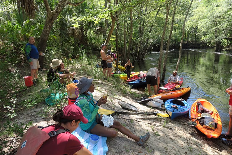
Events, such as this Flint River Grotto paddling trip, help to expose new people to the beauty of the Aucilla. Photo by Doug Alderson.
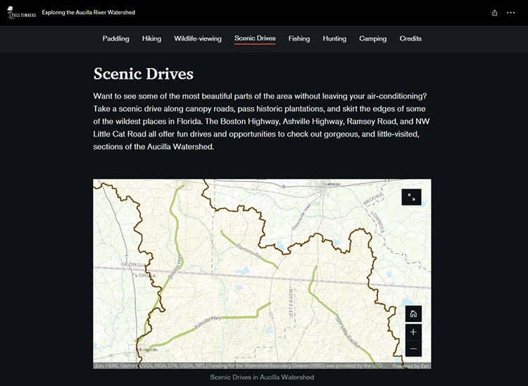
The tool, called a storymap, integrates maps with descriptions and photos to function as an online guide to a given topic. In this case, you can scroll through a tour of the watershed or simply click on the outdoor activity that you are most interested in doing. The maps are activity specific to help you easily figure out how to get from your house to some of the best spots in the Aucilla watershed.
The storymap allows maps and text to flow together, as you can see here in the scenic driving section.
The storymap represents one of many productive collaborations between the Tall Timbers Land Conservancy and the Tall Timbers Geospatial Lab. These kinds of partnerships, in whatever form they take, are almost always of value since they bring people with different ways of approaching problems together. The result is usually something that would not have happened had one group tried to work on the project independently. Whether it’s outreach or conservation, there really is power in partnership.
Those familiar with the Aucilla watershed already know that it’s a paradise in terms of its beauty and the number of ways one can connect with its unparalleled resources. We hope that this storymap helps more people discover the watershed. Through this discovery, we hope that appreciation follows. It’s this appreciation which will result in support for the long-term conservation of the Aucilla and its watershed. For an area this special, it’s important to bring more people into the fold. I sincerely hope that you enjoy the storymap and, more importantly, that you fall in love with some of the places that it features.
For more information about the Aucilla watershed and the efforts of Tall Timbers to conserve it, visit this link.
Suncoast Connector toll road plan largely rolled back
By Neil Fleckenstein, Planning Coordinator
On June 24, 2021, Florida Governor Ron DeSantis signed into law Senate Bill 100, which repeals and replaces the M-CORES plan to build 330 miles of toll roads throughout Florida. SB 100 cancels plans for the Southwest Florida Connector toll road between Polk and Collier counties. Also gone are M-CORES various programs and initiatives that would have encouraged residential and commercial development in rural portions of Florida.
Instead, SB 100 focuses limited roadway improvements on US 19 — only on congested areas well south of Jefferson County; maintains the vast majority of US 19 in its current configuration — thereby avoiding unnecessary construction that would harm natural resources and working rural lands; and saves billions of scarce tax dollars.
Tall Timbers applauds the efforts by the Florida Senate in crafting and passing SB 100 and the Florida House in unanimously supporting this bill. We especially appreciate Senator Gayle Harrell for drafting SB 100 and Representative Randolph Bracy for championing measures from the Toll Road Task Force Reports to protect the environment and vulnerable communities.
The significant scaling down of the Suncoast Connector toll road project was the product of hard work by dedicated Jefferson County residents, conservation organizations around Florida — including Tall Timbers, and thousands of residents throughout the state who opposed this project.
M-CORES is a cautionary tale of the considerable impact that legislative proposals can have on our natural resources and rural communities. At the same time, it’s an affirmation of the power of collaboration among conservation organizations and an energized, informed public.
Tall Timbers encourages residents of the Red Hills and the Florida Big Bend to continue paying close attention to issues large and small that could affect our irreplaceable natural resources, productive working rural lands, and rural land use traditions that make these areas so distinct.
The M-CORES program, which includes the proposed Suncoast Connector Toll Road in Jefferson County, passed through the Florida Legislature at breakneck speed with little review or analysis. Tall Timbers has a number of concerns given the potential for significant and wide spread impacts. These include fragmenting public and private conservation lands, robbing business from Main Street Monticello, impacting our rivers and other water resources, and making prescribed fire more difficult and costly.
Join us in asking the Jefferson County Board of County Commissioners to OPPOSE the Suncoast Connector toll road and its path through Jefferson County.
Take action now with our easy email form.
Send an email to all five Jefferson County Board of County Commissioners with one click!
Burn prioritization modeling seminars and fire modeling tools are supported by Wildland Fire Science to train managers in the important planning stages of prescribed fires.
Educating and guiding the next generation of fire researchers and managers is a key goal of Wildland Fire Science and a resource for testing new ideas in fire research.
Tall Timbers hosts the premier fire technology transfer organization—the Southern Fire Exchange. This JFSP funded effort helps connect research to management through webinars, workshops, and support of the Prescribed Fire Science Consortium.
Working with partners in the Prescribed Fire Science Consortium, the program is building nexgen 3-D fuel beds using terrestrial LiDAR and novel sampling techniques to power new fire behavior models for prescribed fire managers. This work links to Tall Timbers work in wildlife habitat usage and ecological forestry.
The Longleaf Legacy landscape prescribed fire burn team arm of Wildland Fire Science works directly with landowners and partners to effectively put fire on the ground and promote prescribed fire throughout the region.
Tall Timbers is leading an effort to map fire regimes at the landscape scale. Staff work with numerous agencies to evaluate fire records and satellite imagery to build this critical conservation database. https://skfb.ly/6DqOY
Tall Timbers hosts the Prescribed Fire Science Consortium, a national network of researchers and managers who promote integrated research and management to advance next generation tools for fire practitioners. https://arcg.is/1DSjDT
We are linking physics and field observations to understand the fluid dynamics of fire behavior surface fire regimes. Our work combines field observations using advanced thermal imaging techniques, laboratory studies, and coupled fire-atmospheric modeling to help managers improve outcomes of managed fire regimes.
Selected Publications authored by Wildland Fire Science staff.
Staff and researchers support Federal fire training by serving as a cadre for NWCG training courses, ranging from basic wildland fire to advanced fire effects.
(PFTC) specializes in training fire fighters the principles and techniques of prescribed fire through practical hands-on experience. https://www.fws.gov/fire/pftc/
Private land owners are the largest source of prescribed fire in the country. These land owners and the culture of fire that was maintained by them during decades of suppression are a part of why Tall Timbers is a world-wide center for prescribed fire science. Workshops and fire training are a critical focus of the Longleaf Legacy Landscape Burn Team and our support of the Georgia Forestry Commission Prescribed Fire Center in Marion County.
The conserved lands of the Greater Red Hills region are found on working, income-producing properties that support agriculture, forestry, and recreational hunting. These properties contribute $272 million annually to local economies and support 2,300 jobs. [link to Planning & Advocacy section] The landowners’ strong stewardship ethic preserves their working lands while replenishing drinking water supplies, protecting water quality, and providing wildlife habitat for dozens of rare and endangered species. Tall Timbers’ conservation easements on these working properties encourage landowners to retain their traditional livelihood by keeping farms in family ownership.
Home to world-class wild quail populations, the Greater Red Hills region contains the largest concentration of gamebird preserves in the United States. These preserves also support the largest community of Red-cockaded woodpeckers on private lands. Indicators of high quality habitat found here include the gopher tortoise, Bachman’s sparrow, fox squirrel, and many amphibians. Tall Timbers’ conservation easements identify and protect the critical habitats of these species.
The region also boasts outstanding aquatic resources. Large river systems, like the Flint/Apalachicola, Ochlockonee, and Aucilla, flow from Georgia and feed into the Gulf of Mexico to support some of the world’s most productive estuaries. Large disappearing sinkhole lakes, like Iamonia, Miccosukee, and Jackson, provide habitat for an array of aquatic species and migratory birds. Tall Timbers’ conservation easements protect these vital watersheds and wetlands that are the lifeblood for the ecological health of the region.
Once dominated by longleaf pine, our pine woodlands support abundant wildlife and local economies. These forests need prescribed fire to stay healthy. Herbert L. Stoddard and his associates Ed and Roy Komarek were pioneers in this emerging scientific field during the mid-20th century. Tall Timbers continues that legacy with applied research on prescribed fire and land management. Today, there is a tremendous need to expand prescribed fire use beyond the Red Hills to ensure ecosystem health and reduce wildfire risk. Additionally, Tall Timbers uses conservation easements to permanently protect private woodlands while balancing the need for economic return from selective timbering.