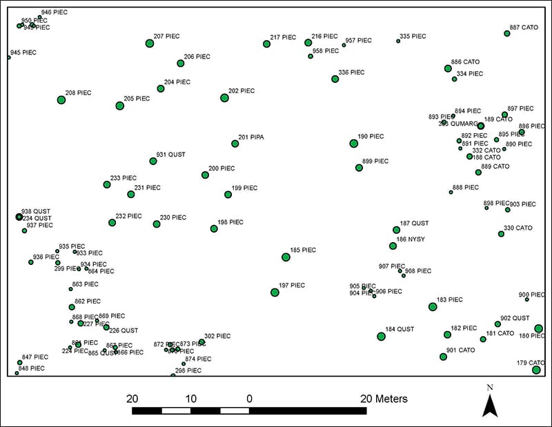
The Fire Ecology and Fire Science labs have initiated a new long-term project to track forest community changes in a native shortleaf pine-oak-hickory community on Tall Timbers Research Station. This natural community type, regionally less well known than the longleaf pine-wiregrass community, has an open canopy of shortleaf pine and upland fire-loving hardwood trees such as mockernut hickory, post oak, southern red oak, white oak, and black oak. The main grass species is little bluestem grass instead of wiregrass, but the community shares a lot of native groundcover indicator species with longleaf pine-wiregrass habitats.
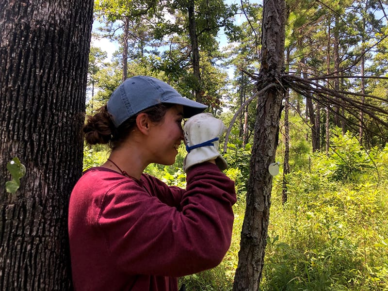
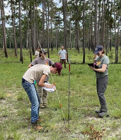
The new study site is in the northwestern quarter of Tall Timbers on the Atkinson Course, also known as the Scrub Course or Jones Course. The Fire Science Lab made terrestrial-based LIDAR scans to create a map of apparent tree locations. The Fire Ecology Lab confirmed locations of larger trees in the field, tagged them, and used them to map smaller trees greater than 2 cm diameter at breast height within a 4-hectare (10-acre) area.
Part of the new map of trees for a long-term study of the shortleaf pine-oak-hickory native community at Tall Timbers Research Station.
The trees will be remapped at two-year intervals to gain knowledge about growth and regeneration of trees in this community type, including the effects of fuel loads and fire on tree recruitment. The new knowledge will be valuable since very little is known about this community type in the Red Hills Region and shortleaf pine ecology in general.
Intern Angela Seibert uses a siting compass to map smaller trees. Other interns conducting the mapping this summer were Makayla Timms and Genevieve Printiss. Photo by Genevieve Printiss
Kevin’s 5th Annual Southern Game Fair celebrates Thomasville’s authentic historical sporting lifestyle by bringing families and community together to promote the preservation of the longleaf pine forests and the bobwhite quail. This charity event benefits Tall Timbers.
The event will be held on the lawn at Tall Timbers in front of the historic Beadel House. Festivities include a cocktail reception, silent and live auction, and dinner. The auction features world class artwork, unparalleled hunting and fishing opportunities, and unique offerings from the Red Hills region and beyond. Reservations are required. The Auction Brochure provides sponsorship opportunities and ticket information. For questions, contact the Development Office at (850) 893-4153 x249.
By Bridget Macdonald Public Affairs Specialist, U.S. Fish and Wildlife Service, North Atlantic-Appalachian Region
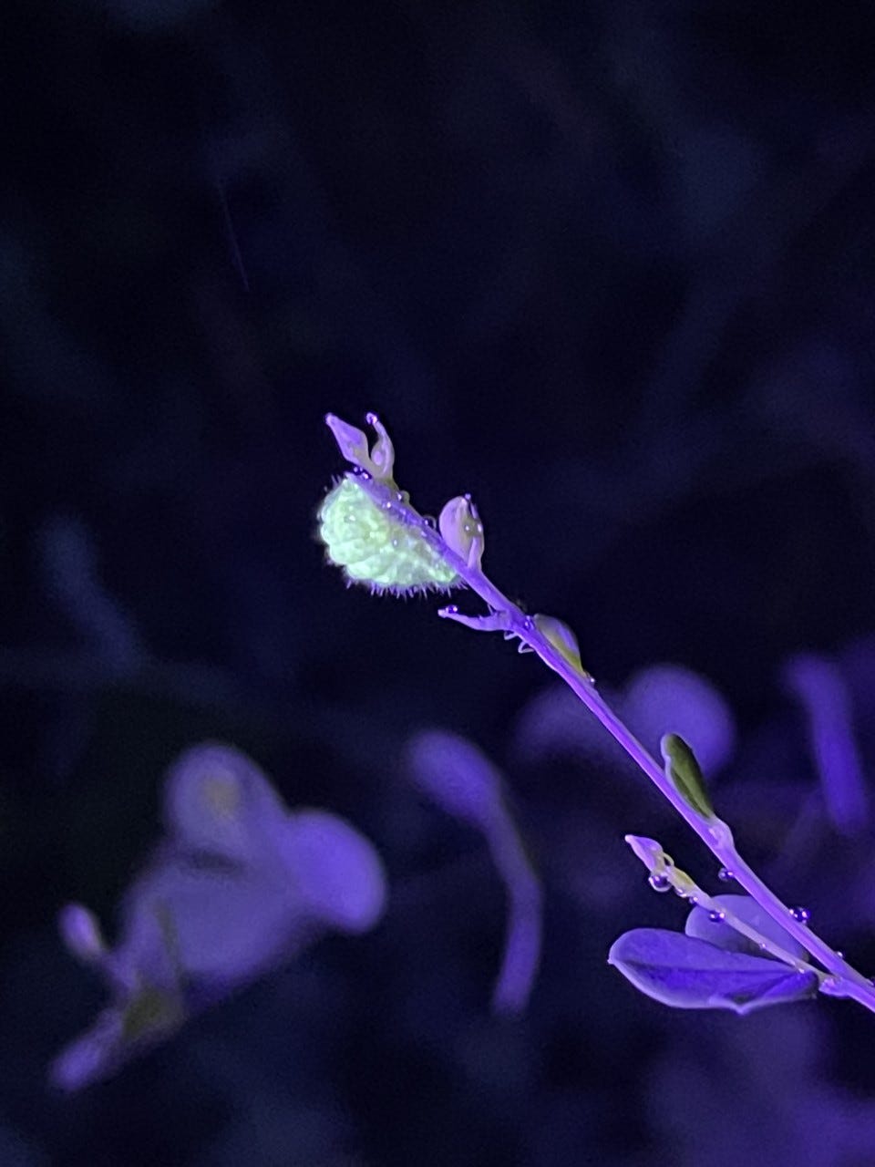
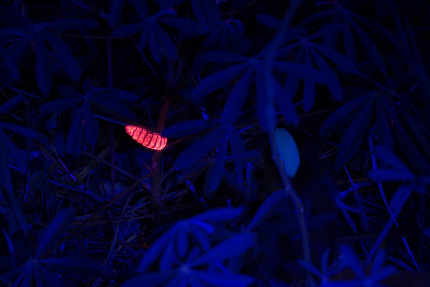
Things that fluoresce under blacklight: the security thread in $100 bill, a forged “Old Master” painting, those groovy posters from the 70s, and the caterpillar of the frosted elfin butterfly.
In fact, according to a paper published by David Moskowitz of Rutgers University, “Many caterpillar species fluoresce, or at least stand out brightly against the background, when exposed to ultraviolet light.”
A glow worm IRL: a frosted elfin caterpillar fluoresces under ultraviolet light.
Moskowitz’s 2019 study documented promising results from trials using ultraviolet, or UV, flashlights to survey for frosted elfin caterpillars at night.
Last year, U.S. Fish and Wildlife Service fellowship biologist Ryan Bell picked up the torch.
Using the findings from the study, he developed a standard blacklight-survey protocol for partners who are helping to look for the rare butterfly across its native range, which spans from Florida west to Texas, and north to the Great Lakes states.
The blacklight surveys for caterpillars don’t replace the surveys for adults during their flight period, which have taken place range-wide since 2019. Rather, they offer a way to make up for missed opportunities. Maybe you couldn’t get to a survey site during the flight period — only about a two-week window in the spring. Or maybe you were at a site during the flight period, but didn’t see any frosted elfin because it was raining.
“They have such a wide range and limited flight window, it can be hard to have people on the ground in the exact right location, at the right time,” Bell explained. “Adding UV light lets us extend surveys three weeks beyond the flight period.”
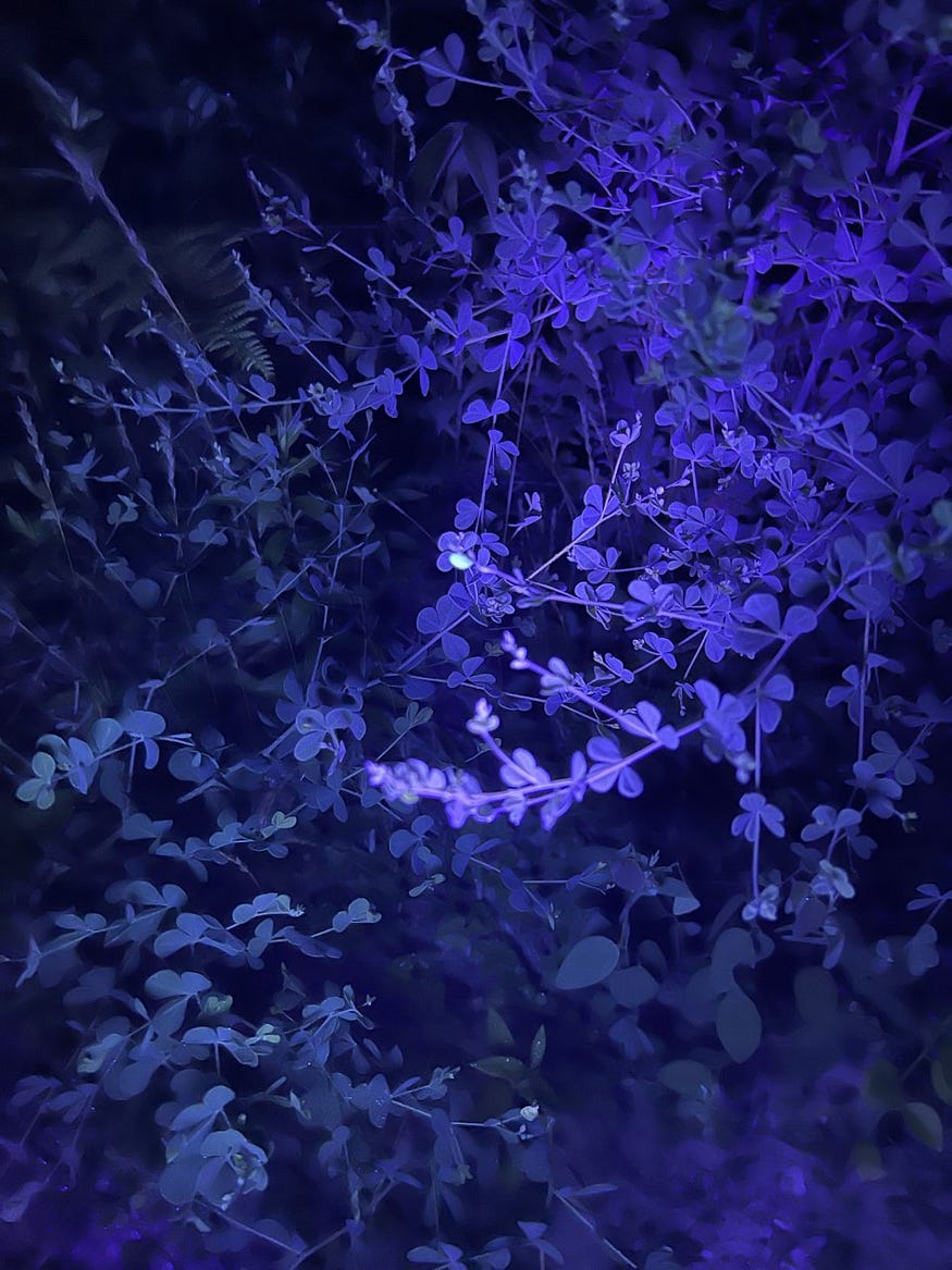
Can you spot the glow worm in this photo?
This summer, the Service’s Science Rapid Response Team, which comprises up to 12 fellowship biologists (including Bell), piloted the approach at sites in Massachusetts, Connecticut, and Rhode Island. The team is engaged in collecting new data to understand the status of a number of species, like the frosted elfin, that appear to be in decline.
Did it work? Fellowship biologist Kathryn Nolan pointed to their experience at The Nature Conservancy’s Carter Preserve in Rhode Island, where they looked for frosted elfin during the adults’ flight period to no avail.
When they went back a couple of weeks later to search after dark using blacklights, she said, “I could see caterpillars glowing from six feet away.”
Light my fire
Partners are using the blacklight survey method, too, including in northern Florida at the Apalachicola National Forest, home to one of the largest known populations of frosted elfin in its range.
“When you have a whole forest to search through, blacklight may be the most efficient way to look for these guys,” said Robert Meyer of Tall Timbers, a research station and land conservancy based in Tallahassee, about 50 miles northeast of Apalachicola.
He had a hunch blacklight would be an efficient way to gather other information on the species, too.
Meyer specializes in red cockaded woodpecker conservation, but because frosted-elfin activity falls outside the breeding season for this bird, he saw an opportunity to contribute to research needs for the butterfly.
“We have the best population of the species an hour away from the station, why shouldn’t we help out?” he said. “Especially because the species will be up for Endangered Species Act consideration in a couple of years. This is the best time to gather information.”
A male frosted elfin butterfly that researchers captured and marked with colored dots. The pattern is a key to where in the forest he was found. Dave McElveen/Tall Timbers
Meyer and colleague Dave McElveen submitted a research proposal to the U.S. Fish and Wildlife Service and the Fish and Wildlife Foundation of Florida (funded through sales of the Conserve Wildlife license plate) to investigate several key issues for managing frosted elfin populations across their range. Their research spans the spectrum, from capturing, marking, and recapturing adults to see how far they disperse — and if they will disperse cross a utility line corridor — to experimenting with novel techniques for distinguishing frosted elfin caterpillars from those of the gray hairstreak, a look-a-like species.
One of the research questions relates to pupation — the stage when butterflies transform from caterpillars to adults. Although the frosted elfin spends the majority of its life as a pupa, scientists don’t know much about what the species looks for in a pupation site.
Knowing where they prefer to pupate could directly inform decisions about habitat management, especially because their habitat requires periodic disturbance. Frosted elfin depend upon wild lupine and wild indigo, plants that grow in fire-tolerant oak-pine barrens, oak savannas, prairie, and dry oak woodlands.
“We know pupa have a tendency to bury themselves, but we want to know where, and how that influences whether they survive fire,” Meyer said. “Maybe there’s something we can do about the environment to increase their potential to survive when we burn.”
Because using prescribed fire to restore frosted-elfin habitat is key to ensuring a future for the species, understanding the potential for pupa to survive fire will help managers use this approach effectively.
To investigate the caterpillars’ pupation preferences, the researchers decided to follow them. That’s where the blacklight comes in.
Although the caterpillars glow on their own, Meyer and McElveen proposed coating them with hot pink biodegradable UV fluorescent powder so they would also leave a glowing trail behind them on the forest floor.
A “pinked up” caterpillar, painted with biodegradable UV fluorescent powder, stands out in the dark under blacklight. Dave McElveen/Tall Timbers
“When we’d see a caterpillar munching on some lupine in the daytime, we’d go over and pink them up, and then come back at night to follow the little breadcrumb trail of powder to see where they went,” Meyer explained.
While the tracking method worked, they didn’t find what they expected at the end of the hot-pink trails.
“We found a lot of shriveled bodies with puncture wounds,” Meyer said, explaining that spider populations tend to boom a few years after an area has been treated with fire.
Fortunately the trail wasn’t completely cold. They did find some pupa that evaded spiders and buried themselves just below the surface of the sand or tucked themselves into a bit of grass.
“My running hypothesis is that they look for someplace dark,” Meyer said.
That could mean the ideal pupation habitat is about two years after a burn, when vegetation is still sparse enough that the caterpillars need to dig down a bit to feel secure, rather than just hiding under a leaf or a pinecone leaving them susceptible to both fire and predation.
They’ll need more data to reach a conclusion, but there’s always next season to pick up the trail. And blacklight will help shed light on the issue.
The effort to conserve at-risk wildlife and recover listed species is led by the Service and state wildlife agencies in partnership with other government agencies, private landowners, conservation groups, tribes, businesses, utilities, and others. It has drawn support for its use of incentives and flexibilities to conserve rare wildlife, reduce regulations, and keep working lands working.
Using Terrestrial LiDAR to Survey Habitat Conditions
By Emily Link and Scott Pokswinski
For the second summer in a row, Tall Timbers collaborated with the US Fish & Wildlife Service (FWS) to collect terrestrial LiDAR data and examine its use as a field monitoring technique. This interagency terrestrial LiDAR project dispersed six fellows across three states in the southeast region to gather data. These locations included St. Marks National Wildlife Refuge (NWR) (St. Marks, Florida), Piedmont NWR (Hillsboro, Georgia), and across the Francis Marion & Sumter National Forest ranger districts (South Carolina). The data collected will not only benefit those sites, but will also allow for a refinement of the overall protocol and development of the capabilities of the technology. This new surveying method will provide a range of data and products that will aid in land management decisions, as it can monitor landscapes rather than isolated ecosystem properties.
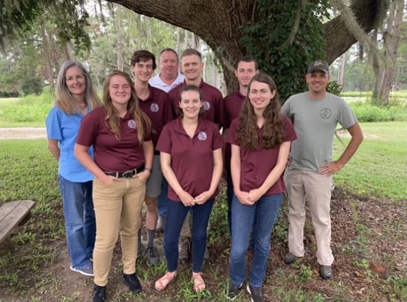
US Fish and Wildlife LiDAR monitoring field team including FWS Directors Fellows; Top left Laila Lienesch, Hugh O’connor (Fellow), Jon Wallace, Evan Monnet (Fellow), Konnor Larkin, Scott Pokswinski; Bottom left Jennah Ruebens (Fellow), Molly Dixon (Fellow), Calista Hnilica (Fellow).
The fellows were given this opportunity through the Directors Fellowship Program. The program provides college students, both undergraduate and graduate, experience working on projects that promote and support the conservation priorities of FWS.
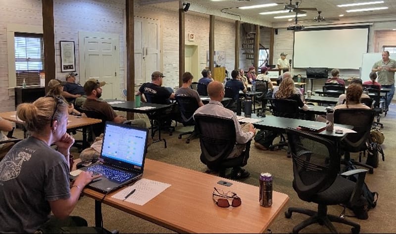
US Fish and Wildlife and US Forest Service employees undergo terrestrial LiDAR monitoring training at Tall Timbers under the Direction of Scott Pokswinski and Jon Wallace.
US Fish and Wildlife and US Forest Service employees undergo terrestrial LiDAR monitoring training at Tall Timbers under the Direction of Scott Pokswinski and Jon Wallace.
The summer began with training at Tall Timbers lead by Scott Pokswinski. Representatives from each location were in attendance to further learn about the process and meet the fellows involved. The two days of training consisted of field technique demonstrations and some of the data development. The fellows then departed from Tall Timbers in teams of two to their assigned sites. Over the next eight weeks the teams trekked through a variety of forest habitats, scanning plots. There were many challenges encountered, ranging from the physical field work, such as maneuvering extreme topography or dense foliage, to the capabilities of the software, including misidentifying telephone poles as trees. It was because of these challenges that inquires have been made and aspects of the process have been improved. At the end of the fellowship program, the project accumulated data from 670 plots.
This interagency terrestrial LiDAR project aims to explore the potential of using terrestrial LiDAR as a plot surveying method. This new use of terrestrial LiDAR technology promotes an increase in monitoring efficiency, while expending less resources. The training required for the field aspect is very straight forward and can easily be learned by individuals without surveying or fieldwork experience. Possible products from these scans include basal area, height to live crown, timber volumes, and fire fuels data. The project is also working towards machine learning to identify fuel loads in LiDAR scans.
The resulting data should inform recipients of the state of the habitat. These outputs are predicted to benefit a variety of interests, especially those related to management. These new techniques may be a way to monitor a habitat’s condition before and after a treatment or natural event. As conditions are better understood and documented through LiDAR, there should be better representation of habitat objectives and what steps should be taken to accomplish objectives including applications for prescribed fire planning and implementation.
The next steps for the project will be processing the data from the plots and extracting useable results. These results will be beneficial in habitat decision making and monitoring, leading to more strategic habitat conservation efforts.
The project would like to thank the fellows for their dedication this summer. The support provided from St. Marks NWR, Piedmont NWR, and the Francis Marion & Sumter National Forest ranger districts is greatly appreciated.
The M-CORES program, which includes the proposed Suncoast Connector Toll Road in Jefferson County, passed through the Florida Legislature at breakneck speed with little review or analysis. Tall Timbers has a number of concerns given the potential for significant and wide spread impacts. These include fragmenting public and private conservation lands, robbing business from Main Street Monticello, impacting our rivers and other water resources, and making prescribed fire more difficult and costly.
Join us in asking the Jefferson County Board of County Commissioners to OPPOSE the Suncoast Connector toll road and its path through Jefferson County.
Take action now with our easy email form.
Send an email to all five Jefferson County Board of County Commissioners with one click!
Burn prioritization modeling seminars and fire modeling tools are supported by Wildland Fire Science to train managers in the important planning stages of prescribed fires.
Educating and guiding the next generation of fire researchers and managers is a key goal of Wildland Fire Science and a resource for testing new ideas in fire research.
Tall Timbers hosts the premier fire technology transfer organization—the Southern Fire Exchange. This JFSP funded effort helps connect research to management through webinars, workshops, and support of the Prescribed Fire Science Consortium.
Working with partners in the Prescribed Fire Science Consortium, the program is building nexgen 3-D fuel beds using terrestrial LiDAR and novel sampling techniques to power new fire behavior models for prescribed fire managers. This work links to Tall Timbers work in wildlife habitat usage and ecological forestry.
The Longleaf Legacy landscape prescribed fire burn team arm of Wildland Fire Science works directly with landowners and partners to effectively put fire on the ground and promote prescribed fire throughout the region.
Tall Timbers is leading an effort to map fire regimes at the landscape scale. Staff work with numerous agencies to evaluate fire records and satellite imagery to build this critical conservation database. https://skfb.ly/6DqOY
Tall Timbers hosts the Prescribed Fire Science Consortium, a national network of researchers and managers who promote integrated research and management to advance next generation tools for fire practitioners. https://arcg.is/1DSjDT
We are linking physics and field observations to understand the fluid dynamics of fire behavior surface fire regimes. Our work combines field observations using advanced thermal imaging techniques, laboratory studies, and coupled fire-atmospheric modeling to help managers improve outcomes of managed fire regimes.
Selected Publications authored by Wildland Fire Science staff.
Staff and researchers support Federal fire training by serving as a cadre for NWCG training courses, ranging from basic wildland fire to advanced fire effects.
(PFTC) specializes in training fire fighters the principles and techniques of prescribed fire through practical hands-on experience. https://www.fws.gov/fire/pftc/
Private land owners are the largest source of prescribed fire in the country. These land owners and the culture of fire that was maintained by them during decades of suppression are a part of why Tall Timbers is a world-wide center for prescribed fire science. Workshops and fire training are a critical focus of the Longleaf Legacy Landscape Burn Team and our support of the Georgia Forestry Commission Prescribed Fire Center in Marion County.
The conserved lands of the Greater Red Hills region are found on working, income-producing properties that support agriculture, forestry, and recreational hunting. These properties contribute $272 million annually to local economies and support 2,300 jobs. [link to Planning & Advocacy section] The landowners’ strong stewardship ethic preserves their working lands while replenishing drinking water supplies, protecting water quality, and providing wildlife habitat for dozens of rare and endangered species. Tall Timbers’ conservation easements on these working properties encourage landowners to retain their traditional livelihood by keeping farms in family ownership.
Home to world-class wild quail populations, the Greater Red Hills region contains the largest concentration of gamebird preserves in the United States. These preserves also support the largest community of Red-cockaded woodpeckers on private lands. Indicators of high quality habitat found here include the gopher tortoise, Bachman’s sparrow, fox squirrel, and many amphibians. Tall Timbers’ conservation easements identify and protect the critical habitats of these species.
The region also boasts outstanding aquatic resources. Large river systems, like the Flint/Apalachicola, Ochlockonee, and Aucilla, flow from Georgia and feed into the Gulf of Mexico to support some of the world’s most productive estuaries. Large disappearing sinkhole lakes, like Iamonia, Miccosukee, and Jackson, provide habitat for an array of aquatic species and migratory birds. Tall Timbers’ conservation easements protect these vital watersheds and wetlands that are the lifeblood for the ecological health of the region.
Once dominated by longleaf pine, our pine woodlands support abundant wildlife and local economies. These forests need prescribed fire to stay healthy. Herbert L. Stoddard and his associates Ed and Roy Komarek were pioneers in this emerging scientific field during the mid-20th century. Tall Timbers continues that legacy with applied research on prescribed fire and land management. Today, there is a tremendous need to expand prescribed fire use beyond the Red Hills to ensure ecosystem health and reduce wildfire risk. Additionally, Tall Timbers uses conservation easements to permanently protect private woodlands while balancing the need for economic return from selective timbering.