Prescribed fire is an important tool across ecosystems to reduce wildfire hazard, maintain fire-prone ecosystems, manage threatened and endangered species, and improve wildlife habitat. Increasing the pace and scale of prescribed burns for fuels management is a major priority to reduce wildfire intensity that endanger communities and disturb habitats. The purpose of the Southeastern Burn Geodatabase Project is to map and analyze the frequency of prescribed burns throughout the Southeast.
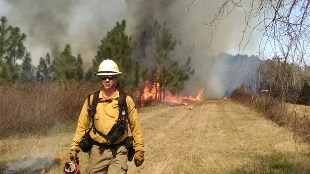
Photo Courtesy of the Prescribed Fire Training Center (PFTC).
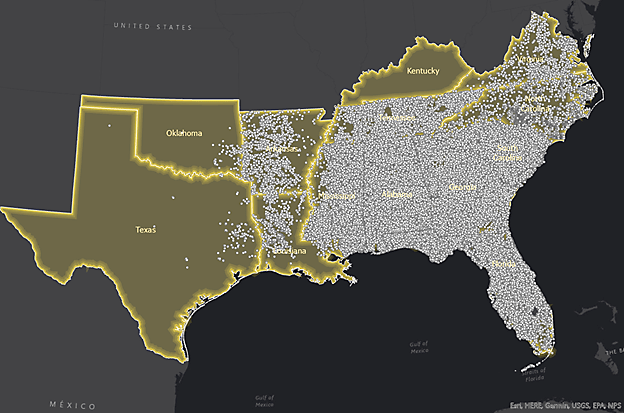
Tall Timbers collected information on how permit location is tracked in the Southeast including what attributes are collected, spatial characteristics, period of record, and data stewardship. Prescribed burn data was then requested from twelve Southeastern states for the 2010-2020 time period, which was then loaded into a database with standardized minimal attributes.
Prescribed burn data collected from the Southeastern states.
Tall Timbers is using this data for a multi-state database, with timely and informative burn data throughout the Southeast United States. This database could also be used by public and private land managers to prioritize areas for treatment with prescribed fire, as well as by scientists and policy-makers, to help answer a variety of questions as we all work to expand the pace and scale of prescribed fire use.
Heat Map of all Burn data (2010-2020) in the Southeast showing the density of burn points, weighted by acreage.
While there are limitations to this data, the burn authorizations are a rich dataset, which can be used in a spatial database as ancillary data for analyses that will further our understanding of prescribed fire occurrence and characteristics. The ultimate goal is to assist prescribed burn practitioners to make better decisions in prioritizing areas of treatment. Capturing the prescribed burn patterns in each of the Southern states may reveal patterns of opportunities and limitations—time of day, seasonality, topography, and cultural preferences.
Special Thanks go to: Alabama Forestry Commission, Arkansas Forestry Commission, Florida Forest Service, Georgia Forestry Commission, Kentucky Division of Forestry, Louisiana Department of Agriculture and Forestry, Mississippi Forestry Commission, North Carolina Forest Service, Oklahoma Forestry Services, South Carolina Forestry Commission, Tennessee Division of Forestry, Texas A&M Forest Service, Virginia Department of Forestry, Fort Benning, and Kisatchie National Forest.
Tall Timbers’ Dr. Morgan Varner on National Public Radio
On August 31, 2021, the eye-catching headline “To Stop Extreme Wildfires, California Is Learning From … Florida?” brought readers and listeners to NPR Morning Edition coverage by Lauren Sommer. Lauren coordinated with Dr. Morgan Varner, Director of Research and a Senior Scientist at Tall Timbers, on the interview and content for the story. We were pleased with her coverage and thoughtful handling of the topic, including the important role of private landowners in expanding and maintaining the use of prescribed fire.
By Alex Jackson, Clay Sisson, Geoff Beane, and Phil Coppola
Long-term data sets are the bread and butter of the Tall Timbers Game Bird Program. Our long-term data sets for radio-tagged quail from the Red Hills, Albany and now Central Florida allow us to monitor different bobwhite populations and how they function. However, we often find ourselves lost in the numbers without focusing on the bigger picture. One major takeaway from looking at these data is that not all high density and stable populations are created in the same way. There has been an ongoing debate among quail biologists in recent years about which demographic is most important: adult survival, reproductive output, male contribution to re-production, or brood survival. We believe the answer is all of the above, and that it can vary from place to place, and even year to year on the same place.
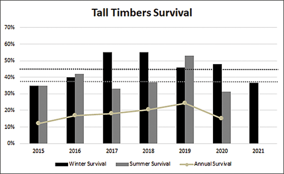
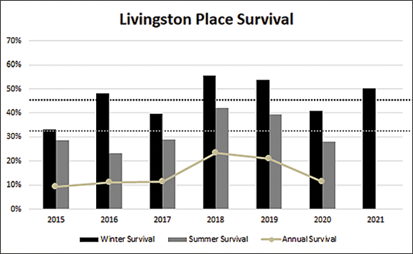
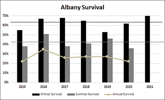
In the Red Hills region of north Florida and south Georgia, overwinter survival on our two study areas (Tall Timbers & Livingston Place) has averaged about 45% since 2014, com-pared to 62% in Albany and 58% on Escape Ranch in Central Florida within the same time period (Figure 1a, b, c, d).
1a. Seasonal and Annual Survival of radio-tagged quail on Tall Timbers near Tallahassee, FL from 2015–2021 compared to the average for the same time period.
1b. Seasonal and Annual survival of radio-tagged quail on Livingston Place near Monticello, FL from 2015–2021 compared to the average for the same time period.
1c. Seasonal and Annual survival in Albany, Ga from 2015-2021 compared to the average for the same time period.
1d. Seasonal and Annual survival on Escape Ranch from 2018-2021 compared to the average for the same time period
However, Escape Ranch is currently a unique situation in that management intensity has dramatically increased over the past 4 years resulting in high survival and reproductive demographics typical of an increasing population.
Nonetheless, lower overwinter survival, as seen in the Red Hills, creates a situation where higher levels of production are typically required to maintain an overall high-density stable population. In Albany, such high production is not always necessary, because overwinter survival is typically higher. So, what does that actually mean? This means per capita production must be higher in the Red Hills to produce a density similar to that of the previous year (and hopefully higher!).
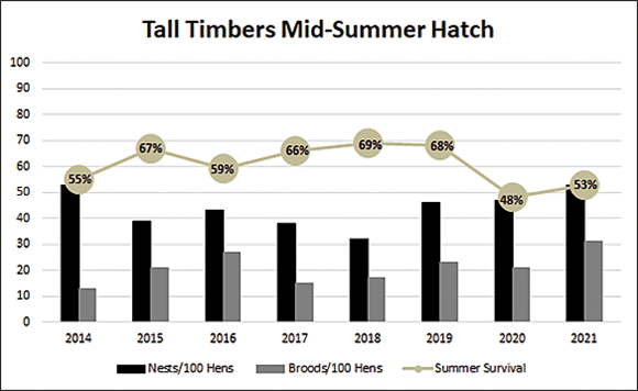
This year’s Red Hills population is being built on a “carry-over” percentage into the spring that was slightly above average on Livingston Place, but well below average on Tall Timbers. Luckily, at the mid-point of the breeding season, female per capita nest and brood production was above average on Tall Timbers and Livingston Place (Figure 2 a, b).
2a. Tall Timbers mid-summer adult survival and nests and broods/100 hens on July 15, 2014-2021.
2b. Livingston Place mid-summer adult survival and nests and broods/100 hens on July 15, 2014-2021
As we discussed in last year’s Quail Call, high male incubation rates are an excellent indicator of strong production. Male contribution has been above average this year on both Tall Timbers and Livingston Place. In fact, between Tall Timbers and Livingston Place approximately 28% of the males in our radio-sample have incubated a nest, compared to only 8% on our Albany site. Again, not all stable populations are created in the same way. Adult survival in the Red Hills was above average on Livingston Place, but below average on Tall Timbers at the mid-point of the breeding season. The excellent early hatch on Tall Timbers and above average survival on Livingston Place provide reason for optimism heading into the second half of the breeding season. Additionally, chick and brood survival have been good due to timely rains and lack of significant weather events. However, while all of this information can produce a fall forecast, there is still time for things to change. The second half of the breeding season is critical for the fall, as these chicks make up the highest proportion of fall juveniles. We will continue to monitor throughout the remainder of the breeding season, to provide a final update and continue to understand and paint the picture for how these different populations maintain stability from year to year.
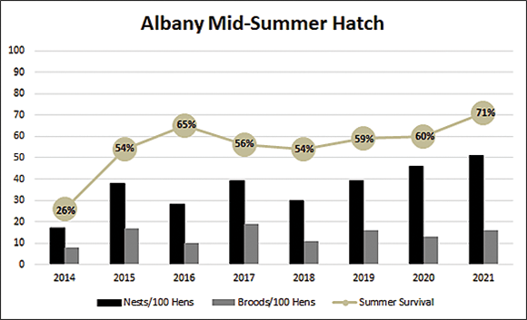
This year’s Albany population is being built upon above average carry-over from what were near record bird densities last fall. The populations in Albany have been on a pretty good run since the last summer drought in 2014, and are apparently still benefiting from the new ground effect following the cleanup from tornadoes in 2017, and hurricane Michael in 2018. Our study site is also benefiting from removal of predator habitat by thinning young pine stands and removing snags, as well as from observing high cotton rat numbers following intensification of coyote and bobcat trapping.
These factors all contributed to 70% overwinter survival coming into spring 2021, which is above the 62% average shown on the graph, and well above our 30-year long term average of 52%. In fact, on April 1 of this year, we documented the record high spring breeding density for the 30 years we have monitored this population. As our President & CEO Bill Palmer likes to say about the region’s property managers, “these folks have gotten really good at keeping quail alive.”
At the midpoint of the nesting season in Albany, female nest per capita is well above average for the time period shown Figure 2c), while brood production per capita is only slightly above average. As mentioned previously, male contribution is low in Albany with less than 10% of males incubating a nest, but this is normal for this population in most years. Summer adult survival is also well above average, which is good news for the second half of the breeding season, and reason for cautious optimism. We will continue to monitor these birds throughout the summer and report on the final hatch numbers in early October.
2c. Albany mid-summer adult survival and nests and broods/100 hens on July 15, 2014-2021.
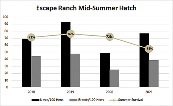
This year marks the fourth breeding season we have had radio-tagged birds on Escape Ranch in central Florida. Central Florida quail operate under a slightly different calendar. What we typically consider the mid-season hatch in Albany and the Red Hills (July 15), is more representative of the latter half of the breeding season in central Florida. Quail in this population typically begin the breeding season in late February or early March, (the first detected nest on Escape Ranch started incubating on March 18th), and hatch their final nests in late August to early September.
While percentage carry-over was below average for this site, high densities the previous fall still resulted in good numbers of potential breeders heading into the spring of 2021. Escape Ranch saw a strong start to the breeding season, with above average female per capita nest production and average per capita brood production (Figure 2d).
2d. Escape Ranch mid-summer adult survival and nests and broods/100 hens on July 15, 2018-2021
Additionally, brood survival has been excellent thus far due to a delayed start of the rainy season in central Florida. Male contribution this year in the central Florida population is similar to what we see in the Red Hills (~20% have incubated a nest), and is indicative of strong production. At the mid-season mark, adult survival is considerably lower than average. However, the late season rains characteristic of central Florida, should improve cover conditions and ultimately have a positive effect on adult survival, facilitating late season productivity. As with our other sites, we will continue to monitor this population and provide a final report at the end of the breeding season.
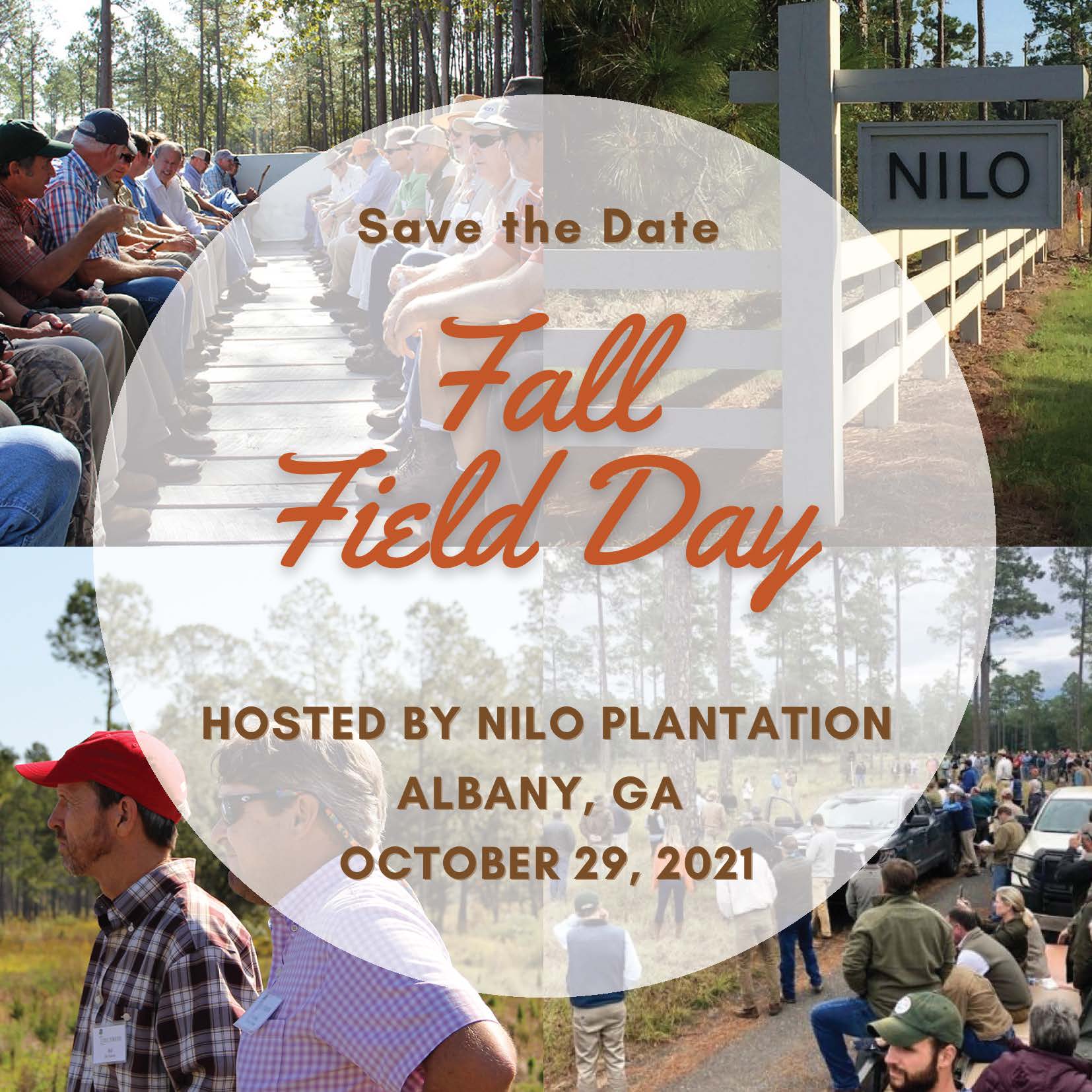
Nilo is an 11,000-acre property in the heart of the Albany, Georgia Quail Plantation belt, well known for its world class wild quail hunting and large whitetails. Nilo is Olin spelled backwards, mirroring the last name of the original owner, John Olin, of Olin Winchester fame. Over 70 years later, the property is still in the family and is owned and operated by his grandchildren. Gene and Evelyn Williams (Mr. Olin’s daughter), were instrumental in establishing the Albany Quail Project in 1993, during their tenure as owners, as well as helping to oversee this project becoming part of Tall Timbers Game Bird Program in 2008. Therefore it is fitting the property would host this year’s event— marking the 30th year of the Albany Quail Project. This year’s tour will highlight intensive quail management on sandy land, large-scale cleanup and reforestation following the tornadoes and hurricanes of the last several years, and trophy whitetail deer management.
Fire Modeling Leaps Forward with California Partners
By Brian Wiebler, Communications Director
Computer models using artificial intelligence, predicting fire behavior, adjusting for atmospheric feedback and ignition patterns may sound out of place for some long-time burners in the Southeast. However, these new tools and technology are critical for planning and supporting decisions to reintroduce fire in complex settings and to supplement training for the workforce needed to maintain and bring back “good fires” across our country.
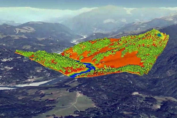
Tall Timbers Fire Scientists Kevin Hiers and Daniel Rosales-Giron, with Board Member and Los Alamos National Laboratory Senior Scientist Dr. Rod Linn, were at the center of a partnership to complete QUIC-Fire in 2020. As the first of these new coupled fire-atmosphere models that does not require a super computer, QUIC-Fire quickly gained attention for applied uses.
The new WIFIRE Lab based at the San Diego Supercomputer Center of the University of California, San Diego has now integrated QUIC-Fire as the model behind its new decision support tool BurnPro3D. WIFIRE has an impressive team of partners focused on advancing data, computing and workflows to tackle the knowledge needs surrounding a wide variety of hazards.
WIFIRE Lab Founder and Principal Investigator Dr. Ilkay Altintas is the Chief Data Science Officer at the San Diego Supercomputer Center. Dr. Rod Linn and Kevin Hiers are both Co-Principal Investigators and Co-Leads for Fire Science on the project. With first year funding of $900,000 from the National Science Foundation and a $5 million phase two proposal pending, WIFIRE is positioned to provide the “cyberinfrastructure” needed to continue developing usable decision support and training tools to expand the use of prescribed fire.
“WIFIRE is exactly the type of technology initiative that Tall Timbers and our partners have been looking for to take our fire science research and leap forward to the fire tools of the future,” explains Hiers. “This is the collaborative approach across disciplines that can get us to big ideas like the ensemble model runs you see for hurricane planning and flight simulators for pilot training. These are now rapidly approaching concepts for prescribed fire planning and training.”
WIFIRE Lab hosts both WIFIRE Commons as a collaborative platform and BurnPro3D as the new decision support tool driven by QUIC-Fire. Additional information on each of these WIFIRE projects follow. You can also visit the WIFIRE Lab website and subscribe to the WIFIRE Lab’s YouTube channel for the latest news, updates and project videos. Tall Timbers will continue to share more with you as this exciting effort moves forward.
WIFIRE Commons is the WIFIRE Lab’s collaborative platform that enables the development of AI-driven societal and scientific wildland fire applications through data and model sharing. The primary objective of the Commons is to create a convergence environment to accelerate wildland fire science and its proactive application to operational use for mitigation, planning, response, and recovery, through AI innovations. To achieve convergence between the AI and fire science communities, WIFIRE Commons develops an intelligent and integrated infrastructure to catalog, curate, exchange, analyze, optimize, and communicate big data and models at scale.
BurnPro3d is a decision support tool, created by the WIFIRE Lab, that harnesses novel ensemble simulations, using a new coupled fire-atmosphere model (QUIC-Fire), to capture the interaction between user-defined complex ignition patterns. BurnPro3D is the only space for active collaboration among land managers, burn bosses, plan approvers, and policy makers that will significantly increase the proactive application of fire in order to successfully combat devastating megafires. Additionally, in fire mitigation and response, BurnPro3D supports users in communicating risks and trade-offs to regulators and the public.
The M-CORES program, which includes the proposed Suncoast Connector Toll Road in Jefferson County, passed through the Florida Legislature at breakneck speed with little review or analysis. Tall Timbers has a number of concerns given the potential for significant and wide spread impacts. These include fragmenting public and private conservation lands, robbing business from Main Street Monticello, impacting our rivers and other water resources, and making prescribed fire more difficult and costly.
Join us in asking the Jefferson County Board of County Commissioners to OPPOSE the Suncoast Connector toll road and its path through Jefferson County.
Take action now with our easy email form.
Send an email to all five Jefferson County Board of County Commissioners with one click!
Burn prioritization modeling seminars and fire modeling tools are supported by Wildland Fire Science to train managers in the important planning stages of prescribed fires.
Educating and guiding the next generation of fire researchers and managers is a key goal of Wildland Fire Science and a resource for testing new ideas in fire research.
Tall Timbers hosts the premier fire technology transfer organization—the Southern Fire Exchange. This JFSP funded effort helps connect research to management through webinars, workshops, and support of the Prescribed Fire Science Consortium.
Working with partners in the Prescribed Fire Science Consortium, the program is building nexgen 3-D fuel beds using terrestrial LiDAR and novel sampling techniques to power new fire behavior models for prescribed fire managers. This work links to Tall Timbers work in wildlife habitat usage and ecological forestry.
The Longleaf Legacy landscape prescribed fire burn team arm of Wildland Fire Science works directly with landowners and partners to effectively put fire on the ground and promote prescribed fire throughout the region.
Tall Timbers is leading an effort to map fire regimes at the landscape scale. Staff work with numerous agencies to evaluate fire records and satellite imagery to build this critical conservation database. https://skfb.ly/6DqOY
Tall Timbers hosts the Prescribed Fire Science Consortium, a national network of researchers and managers who promote integrated research and management to advance next generation tools for fire practitioners. https://arcg.is/1DSjDT
We are linking physics and field observations to understand the fluid dynamics of fire behavior surface fire regimes. Our work combines field observations using advanced thermal imaging techniques, laboratory studies, and coupled fire-atmospheric modeling to help managers improve outcomes of managed fire regimes.
Selected Publications authored by Wildland Fire Science staff.
Staff and researchers support Federal fire training by serving as a cadre for NWCG training courses, ranging from basic wildland fire to advanced fire effects.
(PFTC) specializes in training fire fighters the principles and techniques of prescribed fire through practical hands-on experience. https://www.fws.gov/fire/pftc/
Private land owners are the largest source of prescribed fire in the country. These land owners and the culture of fire that was maintained by them during decades of suppression are a part of why Tall Timbers is a world-wide center for prescribed fire science. Workshops and fire training are a critical focus of the Longleaf Legacy Landscape Burn Team and our support of the Georgia Forestry Commission Prescribed Fire Center in Marion County.
The conserved lands of the Greater Red Hills region are found on working, income-producing properties that support agriculture, forestry, and recreational hunting. These properties contribute $272 million annually to local economies and support 2,300 jobs. [link to Planning & Advocacy section] The landowners’ strong stewardship ethic preserves their working lands while replenishing drinking water supplies, protecting water quality, and providing wildlife habitat for dozens of rare and endangered species. Tall Timbers’ conservation easements on these working properties encourage landowners to retain their traditional livelihood by keeping farms in family ownership.
Home to world-class wild quail populations, the Greater Red Hills region contains the largest concentration of gamebird preserves in the United States. These preserves also support the largest community of Red-cockaded woodpeckers on private lands. Indicators of high quality habitat found here include the gopher tortoise, Bachman’s sparrow, fox squirrel, and many amphibians. Tall Timbers’ conservation easements identify and protect the critical habitats of these species.
The region also boasts outstanding aquatic resources. Large river systems, like the Flint/Apalachicola, Ochlockonee, and Aucilla, flow from Georgia and feed into the Gulf of Mexico to support some of the world’s most productive estuaries. Large disappearing sinkhole lakes, like Iamonia, Miccosukee, and Jackson, provide habitat for an array of aquatic species and migratory birds. Tall Timbers’ conservation easements protect these vital watersheds and wetlands that are the lifeblood for the ecological health of the region.
Once dominated by longleaf pine, our pine woodlands support abundant wildlife and local economies. These forests need prescribed fire to stay healthy. Herbert L. Stoddard and his associates Ed and Roy Komarek were pioneers in this emerging scientific field during the mid-20th century. Tall Timbers continues that legacy with applied research on prescribed fire and land management. Today, there is a tremendous need to expand prescribed fire use beyond the Red Hills to ensure ecosystem health and reduce wildfire risk. Additionally, Tall Timbers uses conservation easements to permanently protect private woodlands while balancing the need for economic return from selective timbering.


 On August 31, 2021, the eye-catching headline “To Stop Extreme Wildfires, California Is Learning From … Florida?” brought readers and listeners to NPR Morning Edition coverage by Lauren Sommer. Lauren coordinated with Dr. Morgan Varner, Director of Research and a Senior Scientist at Tall Timbers, on the interview and content for the story. We were pleased with her coverage and thoughtful handling of the topic, including the important role of private landowners in expanding and maintaining the use of prescribed fire.