Good Quail Hatch and Excellent Male Incubation—a Prelude to Good Fall Bird Numbers
By Theron M. Terhune
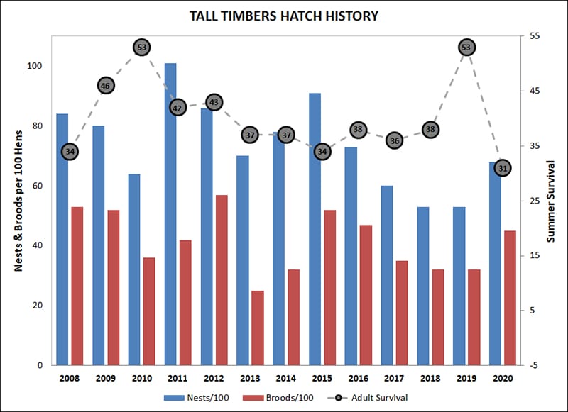
The hatch results are in and they are good—no recount needed! Overall, bobwhite per capita nest and brood production in the Red Hills were moderately above average this year, compared to our historical records. Much of the hatch came from the early (May/June) and mid (July/Aug) season points, with a moderate contribution from the late (Sep/Oct) season hatch. However, adult bobwhite survival in the Red Hills was well below our long-term average.
In contrast to last year, cotton rat numbers seemed to dwindle throughout the breeding season this year, and attrition of our radio-tagged birds paralleled this pattern—adult survival decreased as cotton rat numbers decreased. In fact, this is the lowest adult survival we have seen in the Red Hills over the past 15 years. That said, 2 additional factors provide reason for optimism heading into the 2020–21 hunting season in terms of bobwhite abundance: (1) chick survival and (2) male incubation.
Despite a lot of snake activity, and high loss of bobwhite chicks to snakes this year, overall bobwhite chick survival remained above average; this was evident in scores of mega-broods observed this year which is oftentimes an artifact of the combination of good brood production and good chick survival. Timely rains and good cover conditions produced abundant insect crops and quality protective and foraging cover for broods coming into the fall. Our fall quail trapping efforts, so far, have also indicated good chick survival, especially for late (September and October) hatching chicks resulting in excellent fall recruitment of first year birds. Additionally, we observed that male incubation rates were 29% higher than our long-term average. This is important to fall hunting abundance, because we have recently discovered that male incubation patterns are more predictive of population growth than female incubation patterns. To read more about this, see our article in the latest Quail Call (click here to download). Therefore, high male incubation typically results in population increases. Covey call counts, conducted throughout the Red Hills and Albany area during October and November, confirm excellent male incubation forecasts, quality hatch numbers, and good chick survival, indicative of a moderate population increase (5-10%) in the Southeast.
Although good bobwhite numbers are anticipated this hunting season throughout the region, finding birds could still prove challenging and result in average to below average hunt success. The La Niña weather cycle we are in predicts above average temperatures and below average precipitation during the fall and winter in the Southeast. The warmer, drier weather can present difficult scent conditions for bird dogs, and impact bobwhite movement and behavior. Supplemental feeding can help to keep the birds in good condition during drought periods; keeping bird dogs watered, rotated and fresh should help hunt success during warmer days.
Tall Timbers Develops a New Tool for the Conservation of a Rare Species
By Rob Meyer
In an age of rapid species decline, wildlife biologists must develop ways of re-establishing species to areas where they have gone extinct. Wildlife reintroductions are an increasingly necessary tool for maintaining our natural species diversity. The Stoddard Bird Lab specializes in this technique and has spearheaded successful reintroductions of red-cockaded woodpeckers and brown-headed nuthatches. But can we do it with a rare butterfly?
An adult frosted elfin butterfly. Adults are about 1” tall.
To answer this question, Dave McElveen and I, Tall Timbers researchers, are studying the life history of the rare frosted elfin, a fire-dependent butterfly of sandhills longleaf pine ecosystems. The elfin has been extirpated from large portions of its range in the eastern US, but our local population in the Apalachicola National Forest (ANF) is healthy. This gives us an opportunity to work with elfins without much risk of harming the population. Re-introduction has never been done for frosted elfins, but we set out to learn the if and the how.
Butterflies have four life stages: egg, caterpillar (“cat”), pupa, and adult. For elfins, we thought relocating caterpillars had the best chance of success with the least impact on the “donor” population. Specifically, moving older, larger caterpillars that are just a few days from becoming pupae. This way, the cats were free to choose where they wanted to spend the next nine months as a pupa instead of us deciding for them.
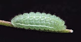
Frosted elfin caterpillars grow to about ¾” in length
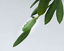
Frosted elfin caterpillars are well camouflaged when feeding on their host plant, sundial lupine.
But how could we keep track of our relocated cats among all the undergrowth and from among all the other cats present? We needed a way to unequivocally identify them. The answer: hot pink fluorescent powder! The powder has been proven safe for caterpillars and is environmentally friendly. So, we gave it a try.
We powdered and relocated 20 cats from 3 different sites within the ANF. We checked on them for 6 days during the day and at night. Much to our delight they fed and developed normally. Also, they retained a lot of their powder even when rained upon. We were even able to follow 3 to their pupation sites thanks to the powder trail they left! This is only the second time pupation sites have been recorded for this species.
Putting fluorescent powder on a caterpillar.
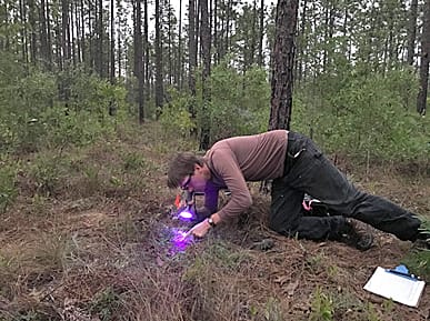
Rob using UV flashlight and glasses at night to spot powdered caterpillars.
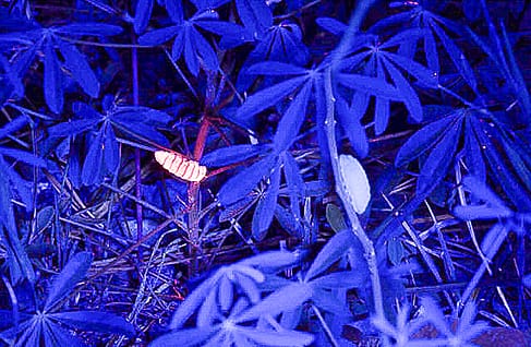
Two ¾” frosted elfin caterpillars under UV light at night: with fluorescent powder(left) and without (right).
Our translocation worked well but much more remains to be understood about how to restore habitat conditions for the elfin before we can return them to where they once were. For now, at least, we have a new tool ready for the next big move in the long-term conservation of this species.
Journey of a frosted elfin caterpillar from its last feeding site (on left) to pupation site (on right).
Powdered caterpillar beginning to pupate in soil.
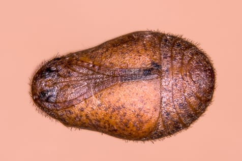
Frosted elfin pupa (~3/4” long). Frosted elfins spend 9 months of their life in this stage as they transform into an adult.
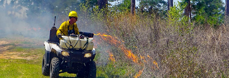
The COVID-19 pandemic has profoundly impacted lives around the world in countless ways. To help learn more about one of these many impacts, Tall Timbers is working with the NASA Earth Science Division through their Rapid Response program and the Forest Service Rocky Mountain Research Station, Missoula Fire Lab to measure and better understand changes in the use of prescribed fire during the pandemic. This research is part of an effort to help mitigate the negative consequences of the pandemic on the wildfire risk reduction benefits and wildlife habitat benefits of prescribed fire use.
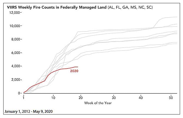
In March 2020, as the pandemic began to spread in the United States, many organizations halted or reduced their prescribed fire programs to help maintain social distancing for those who conduct burns, and address uncertainty regarding the potential for smoke to aggravate COVID-19 symptoms. These changes overlapped with peak months for prescribed fire use in the Southeast. NASA satellites detected a 50% reduction in active fires in March 2020, and the reduction in fires has continued in the Southeast through Fall 2020. The pandemic is now in position to impact a second peak prescribed fire season for the Southeast in early 2021.
The graph below shows that spring 2020 had the fewest active fire detections on federal lands of any spring in the Visible Infrared Imaging Radiometer Suite (VIIRS) nine-year record. Likewise, NASA’s Moderate Resolution Imaging Spectroradiometer (MODIS)—a similar sensor but with a longer data record—showed spring 2020 fire counts were the lowest in a 16-year record.
However, the Red Hills region of southwestern Georgia and north Florida actually showed some increase in fire activity in spring 2020. It is believed that private lands managers in the Red Hills prioritized doing prescribed fires more quickly than usual, as uncertainty about COVID-19 and possible changes in burning restrictions in Florida and Georgia loomed.
In many areas a backlog of lands that need to be treated with prescribed fire already exists, and the federal government shutdown of 2018-2019, and the COVID-19 pandemic in Spring 2020, have both added to this fire deficit. Fire is a natural process, and without prescribed fire as a safe substitute, forest and grassland fuels accumulate and cause more destructive wildfires that can be negative for wildlife and society.
Tall Timbers worked with the Southern Fire Exchange on a webinar to share this data and host a panel discussion on creative strategies and success stories that have come out of fire management during the pandemic. The webinar was recorded and is available here.
Hog Havoc, a free mobile app developed by Tall Timbers, is now available
By Kim Sash and Kelsey Hoskins
“Resilient,” “destructive,” and “expensive” are a few words that come to mind when referring to the feral swine (hog) populations within the Red Hills region. The notorious animals have been introduced (accidentally and intentionally) to North America on multiple occasions over time, and have since developed into the perfect invasive species. These opportunistic omnivores are equipped for rooting, quick reproduction, and disturbing native wildlife like wild turkeys, white-tailed deer, and northern bobwhite. Their rooting behavior severely damages multiple ecosystems and agricultural crops, resulting in multimillion-dollar revenue losses annually. With populations having increased over the last 30 years, the Red Hills region now suffers from excessive damage caused by hogs. In response to such damage, property owners are looking for an easier way to pinpoint and mitigate feral hogs for quicker trapping efforts.
Hog Havoc, a free mobile app developed by Tall Timbers, is now available on all smartphone platforms, to allow the public to quickly provide wildlife managers with locations of feral hog populations. When you find live hogs or rooting on your property, you can mark each site with a GPS location in Hog Havoc, and also describe the habitat and estimated cost of any damage. The location of the site will be automatically and privately submitted to Tall Timbers biologists.
This information will help guide our current and future trapping throughout the region. Although our trapping project is limited to the Red Hills, documented hog signs can also be important for other areas. Please use the Hog Havoc app whenever you are, to help Tall Timbers track feral hog populations! The more data we collect, the greater ability we have to demonstrate the need for resources to help control this invasive species.
The Hog Havoc app can be accessed here: https://ttrsmaps.org/projects/hogs/. To get the app on a mobile device, simply click on the link and add it to your home screen. All of your data is private and not accessible to the public.
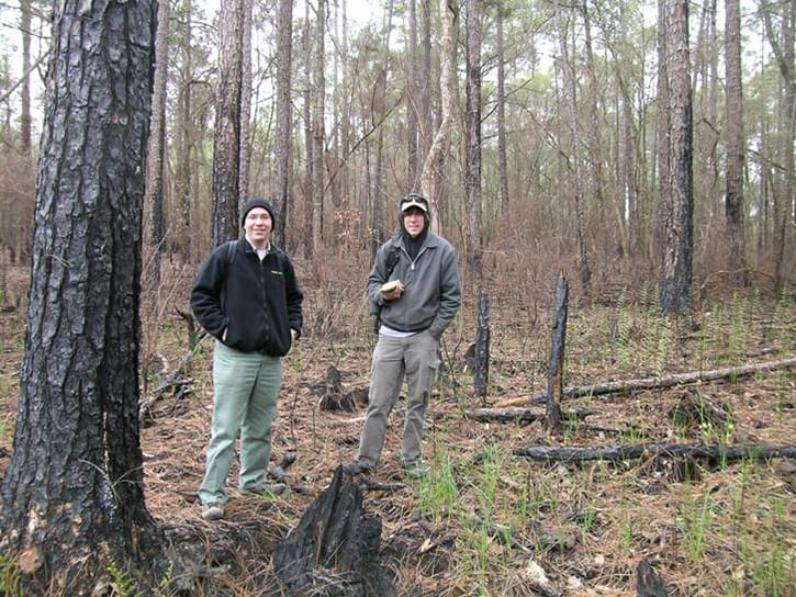
The Fire Ecology Program has been collaborating with Josh Picotte and other scientists at the U.S. Geological Survey, and two universities to publish a nation-wide assessment of our ability to map the severity of wildfires and prescribed fires using satellite remote sensing technology. Josh got his professional start at Tall Timbers in 2006, and since then has become a national leader in the field of remote sensing of burn severity. While at Tall Timbers, he focused on measuring burn severity, or the degree of change in vegetation and soil caused by fire, in plots on the ground, to calibrate data collected by satellites to map out burned areas in the southeastern U.S. For the current research, such plots have been compiled from around the country, totaling 5850 plots collected following 231 fires.
Josh Picotte (right) and Jason Drake (left) measuring a burn severity plot in the Apalachicola National Forest.
The specific goal of the study is to compare the accuracy of remote sensing of burn severity, using models that were developed at different spatial scales. So, one model was developed using all of the plots across the country using all fires, and others were developed with plots and fires within broad ecological regions, and others in smaller ecological regions, and so on. Models developed for local regions might be expected to be more accurate within those regions, but the tradeoff is that there are fewer plots to develop the model.
We found that, overall, models created for local regions are the most accurate, but there are exceptions, especially in regions where not many plots have been measured on the ground to calibrate the model. To help choose the best model for a particular fire, we created a “decision tree” to walk the user through the process of picking a model. Results of the research should provide an important advance in the ability of agency programs, such as Monitoring Trends in Burn Severity, to more accurately map burned areas. Maps of burned area and burn severity are important for many applications, including assessment of fire impacts on natural resources, creating national pollution emissions inventories, modeling the global carbon cycle to predict climate change, and monitoring the effects of climate change on trends in fire occurrence and effects.
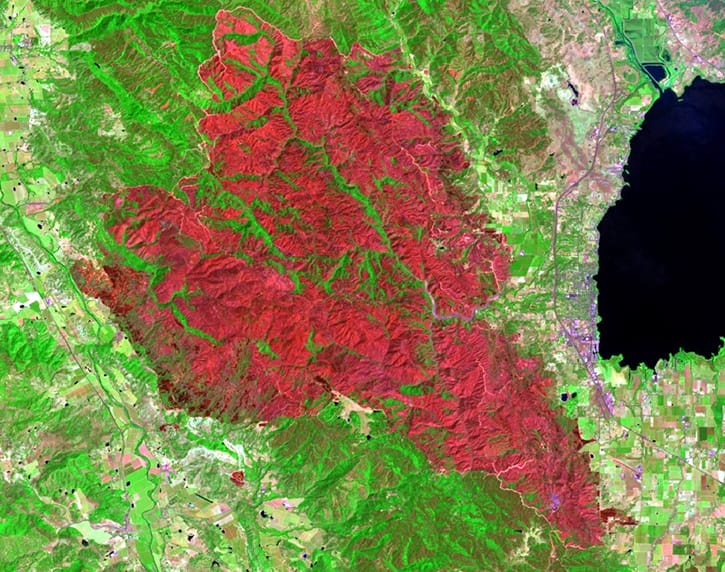
Burn severity map of the River Fire in northern California, 2018, with redder areas indicating higher burn severity.
The M-CORES program, which includes the proposed Suncoast Connector Toll Road in Jefferson County, passed through the Florida Legislature at breakneck speed with little review or analysis. Tall Timbers has a number of concerns given the potential for significant and wide spread impacts. These include fragmenting public and private conservation lands, robbing business from Main Street Monticello, impacting our rivers and other water resources, and making prescribed fire more difficult and costly.
Join us in asking the Jefferson County Board of County Commissioners to OPPOSE the Suncoast Connector toll road and its path through Jefferson County.
Take action now with our easy email form.
Send an email to all five Jefferson County Board of County Commissioners with one click!
Burn prioritization modeling seminars and fire modeling tools are supported by Wildland Fire Science to train managers in the important planning stages of prescribed fires.
Educating and guiding the next generation of fire researchers and managers is a key goal of Wildland Fire Science and a resource for testing new ideas in fire research.
Tall Timbers hosts the premier fire technology transfer organization—the Southern Fire Exchange. This JFSP funded effort helps connect research to management through webinars, workshops, and support of the Prescribed Fire Science Consortium.
Working with partners in the Prescribed Fire Science Consortium, the program is building nexgen 3-D fuel beds using terrestrial LiDAR and novel sampling techniques to power new fire behavior models for prescribed fire managers. This work links to Tall Timbers work in wildlife habitat usage and ecological forestry.
The Longleaf Legacy landscape prescribed fire burn team arm of Wildland Fire Science works directly with landowners and partners to effectively put fire on the ground and promote prescribed fire throughout the region.
Tall Timbers is leading an effort to map fire regimes at the landscape scale. Staff work with numerous agencies to evaluate fire records and satellite imagery to build this critical conservation database. https://skfb.ly/6DqOY
Tall Timbers hosts the Prescribed Fire Science Consortium, a national network of researchers and managers who promote integrated research and management to advance next generation tools for fire practitioners. https://arcg.is/1DSjDT
We are linking physics and field observations to understand the fluid dynamics of fire behavior surface fire regimes. Our work combines field observations using advanced thermal imaging techniques, laboratory studies, and coupled fire-atmospheric modeling to help managers improve outcomes of managed fire regimes.
Selected Publications authored by Wildland Fire Science staff.
Staff and researchers support Federal fire training by serving as a cadre for NWCG training courses, ranging from basic wildland fire to advanced fire effects.
(PFTC) specializes in training fire fighters the principles and techniques of prescribed fire through practical hands-on experience. https://www.fws.gov/fire/pftc/
Private land owners are the largest source of prescribed fire in the country. These land owners and the culture of fire that was maintained by them during decades of suppression are a part of why Tall Timbers is a world-wide center for prescribed fire science. Workshops and fire training are a critical focus of the Longleaf Legacy Landscape Burn Team and our support of the Georgia Forestry Commission Prescribed Fire Center in Marion County.
The conserved lands of the Greater Red Hills region are found on working, income-producing properties that support agriculture, forestry, and recreational hunting. These properties contribute $272 million annually to local economies and support 2,300 jobs. [link to Planning & Advocacy section] The landowners’ strong stewardship ethic preserves their working lands while replenishing drinking water supplies, protecting water quality, and providing wildlife habitat for dozens of rare and endangered species. Tall Timbers’ conservation easements on these working properties encourage landowners to retain their traditional livelihood by keeping farms in family ownership.
Home to world-class wild quail populations, the Greater Red Hills region contains the largest concentration of gamebird preserves in the United States. These preserves also support the largest community of Red-cockaded woodpeckers on private lands. Indicators of high quality habitat found here include the gopher tortoise, Bachman’s sparrow, fox squirrel, and many amphibians. Tall Timbers’ conservation easements identify and protect the critical habitats of these species.
The region also boasts outstanding aquatic resources. Large river systems, like the Flint/Apalachicola, Ochlockonee, and Aucilla, flow from Georgia and feed into the Gulf of Mexico to support some of the world’s most productive estuaries. Large disappearing sinkhole lakes, like Iamonia, Miccosukee, and Jackson, provide habitat for an array of aquatic species and migratory birds. Tall Timbers’ conservation easements protect these vital watersheds and wetlands that are the lifeblood for the ecological health of the region.
Once dominated by longleaf pine, our pine woodlands support abundant wildlife and local economies. These forests need prescribed fire to stay healthy. Herbert L. Stoddard and his associates Ed and Roy Komarek were pioneers in this emerging scientific field during the mid-20th century. Tall Timbers continues that legacy with applied research on prescribed fire and land management. Today, there is a tremendous need to expand prescribed fire use beyond the Red Hills to ensure ecosystem health and reduce wildfire risk. Additionally, Tall Timbers uses conservation easements to permanently protect private woodlands while balancing the need for economic return from selective timbering.