The Western Pineywoods Quail Program established to restore bobwhite populations to east Texas
By Brad Kupecka, Western Game Bird Program Director
Texas is a well-known destination for quail hunters across the globe, but the backdrop of a Texas covey rise doesn’t often portray a fire managed pine savannah. While quail populations are abundant in the semi-arid regions of the Rolling Plains and south Texas, very little research or management attention has been afforded to the forested region of the state—at least not in the past several decades. As a matter of fact, the “fire bird” has been all but extirpated from the Pineywoods of the Lone Star State, where past populations would rival or surpass those in the west.
With growing angst from Texas quail hunters to restore bobwhite populations to the eastern region of the state, Tall Timbers was strongly encouraged to create a program in east Texas by Mr. Chuck Ribelin, an avid quail hunter and advocate, who appreciates Tall Timbers’ proactive approach to quail management. Thanks to Mr. Ribelin’s generous financial support, ideas, and encouragement, Tall Timbers’ entry into east Texas, and surrounding areas, became a reality earlier this year. The Western Pineywoods Quail Program (WPQP) was established in late 2020, and is the newest regional addition to the Game Bird Program at Tall Timbers, with the goal of restoring bobwhite populations to the Pineywoods ecoregion of Texas and surrounding areas, using scientifically-based management and outreach.
Already, interest and support for our newest program has been fantastic and greatly appreciated. We’ve received funds from several private donors such as Park Cities Quail Coalition (PCQC) in Dallas, and most recently, Texas Parks and Wildlife. Collectively, these funds are supporting a new biologist position and our first research project on private lands. Knowing that time and consistency are needed for success in quail management, Tall Timbers has secured over half of a $4 million endowment campaign to secure the program’s positions in perpetuity, ensuring this region will always have a core of bobwhite research and stakeholder guidance.
An inaugural research project near Livingston, Texas to restore bobwhite habitat and populations was hatched last year, with the gracious support of the Gordy family of Houston. This project has an audacious vision to restore over 8,000 acres of habitat with the implementation of prescribed fire, timber and brood field management, supplemental feeding, and predator control. Tall Timbers is also providing technical support to neighboring properties to increase the footprint of this project. Bobwhite populations in the Pineywoods are sparse, and not expected to responded to habitat management alone.
Once high-quality habitat is restored, the Game Bird Program will use translocation as a tool to augment the population. From there, many questions are set to be answered regarding the ecology of bobwhite in this region. Fortunately, Tall Timbers’ long history of quail research and management in the Red Hills provides a good foundation for baseline management recommendations. With time, the program seeks to develop collaborative efforts on both private and public lands across the Pineywoods, which hosts over half a million acres of Texas’ public lands. Past and successful collaborations on state and federal lands in Florida and Georgia, provide good blueprints to replicate the efforts.
For more information about the Western Pineywoods Quail Program research, habitat management, or to support the WPQP endowment campaign, please contact Brad Kubecka.
The 2020–2021 hunting season for wild quail was another great one in the Red Hills and Albany Areas and across the Southeast! Locally, some properties had one of their best seasons on record. Additionally, properties in the Carolinas, Alabama, and Central Florida observed high covey finds for their respective areas, further increasing landowner interest in wild quail hunting opportunities. What facilitated this year’s successes? Overall, hunt success is due to a combination of good cover conditions, high bird carryover, and favorable scenting conditions. Clay Sisson, the Director of the Albany Quail Project and Livingston Place Research further provides the following reflective thoughts and future perspective:
This “bull market” has been the result of excellent management helped along by good summer weather, high cotton rat numbers, and a widespread new ground effect, as a result of cleanup following the 2017 tornadoes and hurricane Michael in 2018. We documented these high-density populations back in the fall, but it’s always interesting to see what the hunting season brings. Despite a warm and dry forecast, we had great weather most of the season. Abundant rainfall and cool temperatures made for good hunting condition’s right up until the last week of February. These high densities and good hunting weather made for a memorable hunting season that was at or near record levels in some cases.
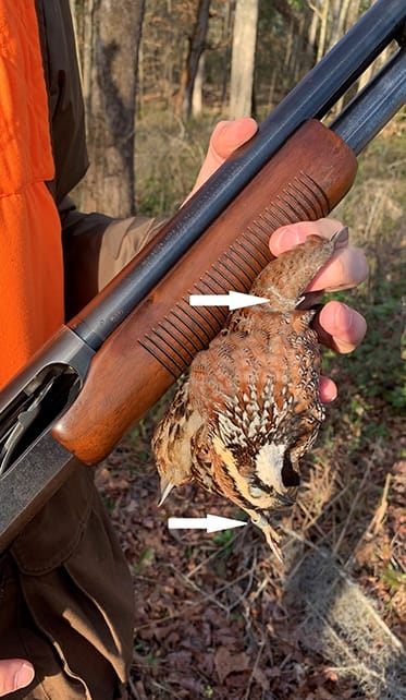
A harvested bird that was wing tagged as a chick and leg banded later as an adult.
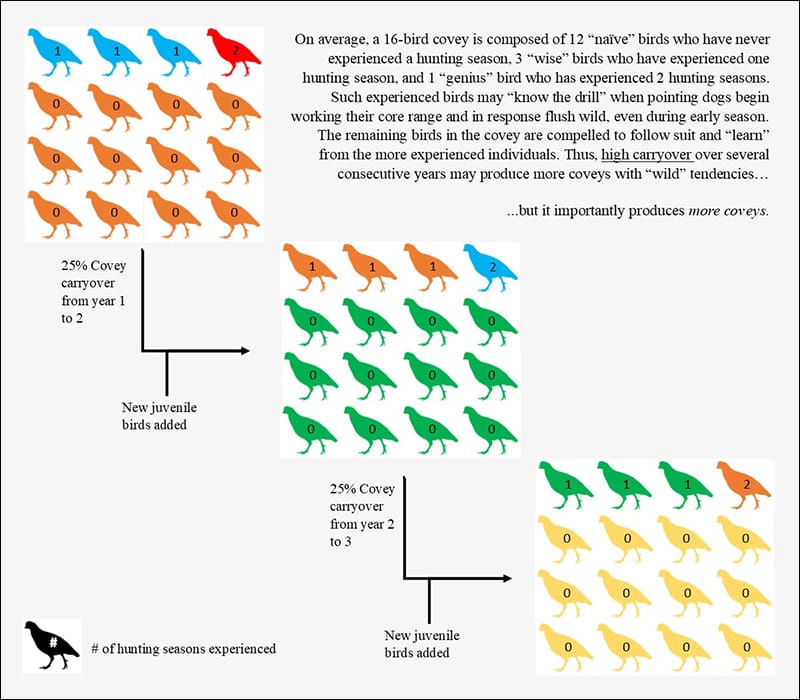
One thing we heard over and over this year was how “wild” the birds were during hunts. While we hear this every year late in the season, this year it was widespread throughout the season, and much more than usual. We think this is due, at least in part, to the high-density populations and high carryover the previous few years (see diagram). In oversimplified terms think of it like this: at the 25% annual survival we have averaged the last few years, there are 4 birds in every 16-bird covey that were around last hunting season, and one of these was around 2 seasons ago. They know the drill and are “teaching” the newcomers how to evade you. Most of you know, as well, how a covey of birds can’t stand to hear another one fly. To them this means something is wrong, and chances are they are going to get up and go with them, if they are nearby. In high density populations, the chance for this occurring is high, with it not being unusual to see multiple coveys in the air at one time. While this is fun to see, it leads to an overall lower percentage of coveys being shot at. This is like the landowner with too many saw timber pine trees; it’s a good problem to have.
Carryover this year, so far, is again very good. Radio-tagged quail survival at the end of February was 74%, 56%, and 47% at our Albany, Livingston Place, and Tall Timbers’ sites, respectively. All are close to or above long-term averages. Unless the wheels come off in March, we will have very good “carryover” into the official beginning of the breeding season on April 1. This is all good news and reason to be optimistic; however, we also know that it is not a matter of “if”, but “when” this bull market will end. The best position to be in when that occurs is with high spring breeder numbers so that the population does not fall too far and can recover quickly. Keep your fingers crossed that these abundant rains we have experienced will continue when we need them throughout the growing season.
The effort of several Fire Ecology interns over two years is coming to fruition in a new map of forest community types on Tall Timbers Research Station. Until now, our maps were not much more specific than identifying upland pine forests, hardwood forests associated with low areas, and and open wetlands. Building on data provided by a timber cruise made in the upland pine areas a few years ago, the Fire Ecology Lab extended the area covered by the 1-acre survey points to extend throughout the rest of the property. At each point, all trees greater than 10 cm diameter, within a 15 m radius, were recorded, identified to species, and put into a size category. We combined the timber cruise data and new data and ran a cluster analysis to classify each point according to its tree species composition.
The analysis ended up producing 12 forest community types: upland loblolly-shortleaf pine, upland shortleaf pine, shortleaf pine-oak-hickory, longleaf pine, hardwood slope forests (mostly hickory), ravine forests (with tulip poplar, sweetbay, and gums), upland fire-excluded pine-hardwoods, wetland early successional hardwoods, beech-magnolia forest, live oak-loblolly pine bottomlands, gum swamp, and cypress swamp. Other categories mapped are open wetlands, fields, and developed areas.
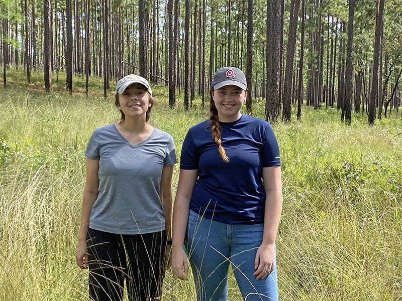
Interns Emma Zeitler (left) and Madeline Lyons (right)
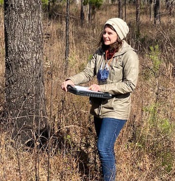
Intern Courtney Gunville
The field effort was led by interns Louie Sandstrum, Porter Taylor, Madeline Lyons, and Emma Zeitler, with Emma completing most of the work this past fall. Courtney Gunville, who recently graduated from the University of Wisconsin in GIS, is currently working on interpreting the points to draw polygons covering the map with forest community types and other land categories.
The map will be useful for both Tall Timbers researchers and visiting scientists interested in the various natural resources the property has to offer. It speaks to the considerable ecological diversity at relatively small scales on Tall Timbers and similar properties throughout the Red Hills Region.
Map of Tall Timbers Forest Communities in progress
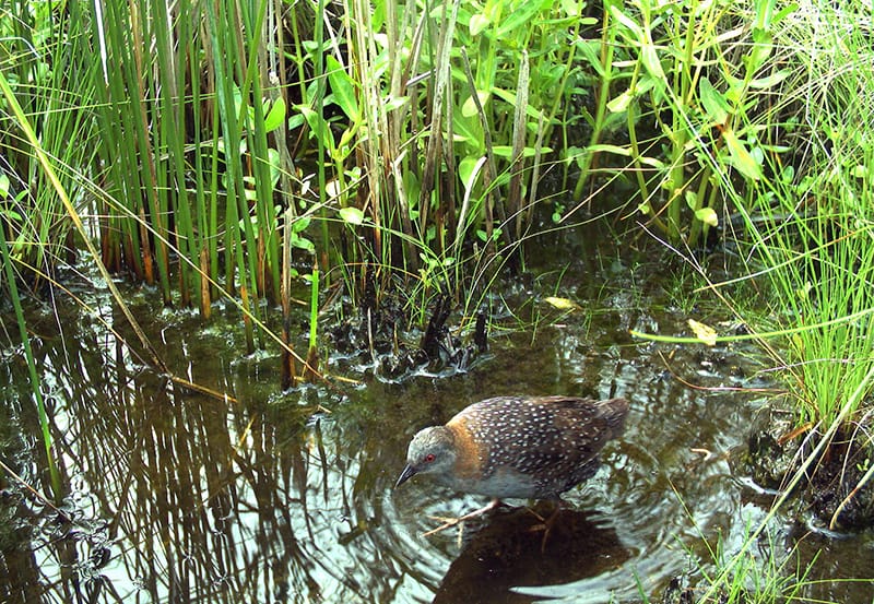
The Black Rail is an especially elusive and challenging subject for birders, conservationists, and land managers. This sparrow-sized bird is described as ‘the most secretive bird in North America’, a white whale among feathered beasts because it spends most of its time running underneath thick vegetation in coastal and interior marshes. It acts more like a mouse than a bird, and to make matters worse, rails are crepuscular (become active at twilight), and vocalize primarily after the sun has gone down or a few hours before it rises the following morning.
Female Eastern Black Rail in South Carolina, USA. (Photo: Christy Hand, South Carolina DNR, taken under SCDNR research permit BB-20-06).
High marshes are characterized by infrequent tidal inundation and are dominated by a mix of cordgrass, pickleweed, saltgrass, or black rush.
The inability to detect rails reliably has led to knowledge gaps in their conservation and management needs, but one issue is clear―the rail is in steep decline. A population loss of at least 75% over the past 10−20 years is estimated for the eastern Black Rail, the sub-species that lives in the Florida panhandle year-round. The declines, coupled with habitat fragmentation and future projections of severe habitat loss as sea levels rise, have led to designation of the rail as an Endangered Species, and underscored the need for better management information.
Fire suppression is another factor that may be affecting rails. Fire suppression has shifted plant communities that rails depend on, allowing undesirable shrubs and small trees to encroach into once suitable habitat. However, there are a lot of questions regarding the timing, frequency, and size of burns. Burning during critical periods when birds are nesting or when they are temporarily flightless from molting may increase mortality of both chicks and adults. There is a critical need to understand the ‘sweet spot’ of burning that will best improve habitat while decreasing direct threats to the birds.
As part of the National Oceanic and Atmospheric Administration (NOAA) Firebird project, a multi-state effort studying waterbirds along the Gulf, the Stoddard Bird Lab will be getting our feet wet and muddy to study Black Rails across six Florida counties. The study stretches from the Lower Suwanee National Wildlife Refuge in Levy County to St. Vincent National Wildlife Refuge in Gulf County; our focus is to assess the effects of prescribed fire on rail habitat use.
We are currently monitoring four prescribed fires conducted in coastal wetlands this past year, and additional burns will be added to help determine appropriate return intervals. Understanding when these communities would have naturally burned, how frequently, and in what sizes and patterns will help us restore high-quality habitat. In addition, we will be testing different calls used during surveys to increase detection rates, as well as banding birds in the study area to get a better idea of distribution, population size, and habitat use.
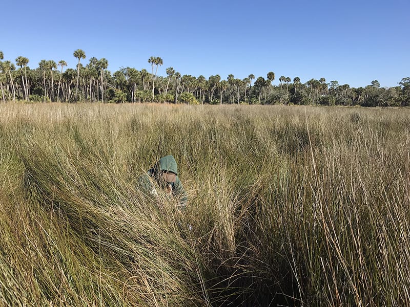
Stoddard Bird Lab member Destinee Story Braden measuring vegetation in a very tall patch of black rush.
Our long-term goal is to create a monitoring and management plan for Black Rails along the Gulf Coast using adaptive management, a process of conducting habitat management, monitoring responses, and adjusting management based on the response and the insights of stake-holders that include managers, decision-makers, and researchers. This dynamic scientific process allows for flexibility across the board and a great collaborative effort across the Gulf states. The Black Rail may have been quietly slipping under the radar, but with the help of many dedicated folks, we hope to put a bit more light on many of the conservation challenges facing this elusive bird.
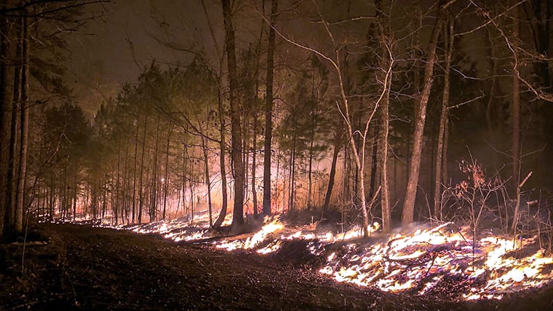
Burn Team provides novel approach to expanding private lands prescribed fire use
The Tall Timbers Burn Team fills a valuable niche that directly aids in the use of fire on private lands. This is a small, well-trained unit that engages, educates and assists landowners to apply more fire on their land. In its first two years, the Team has already worked with hundreds of landowners across thousands of acres in Florida, Georgia, and Alabama.
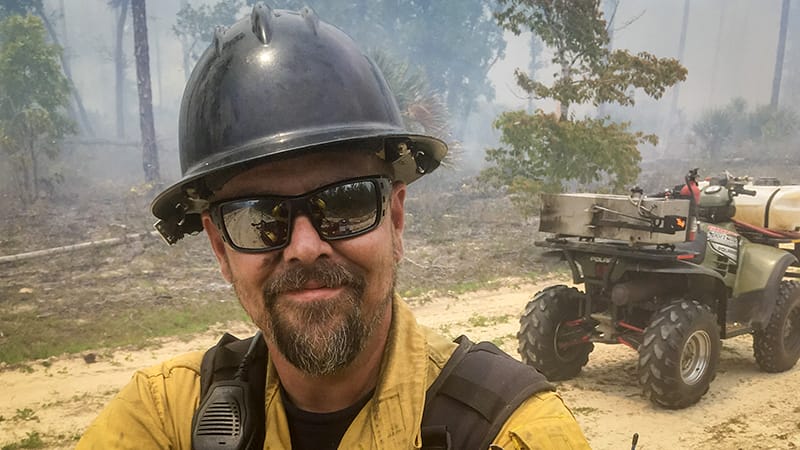
Jeremiah Cates, Private Lands Prescribed Fire Coordinator, conducts a prescribed fire on private lands.
The Burn Team was established within the Tall Timbers Private Lands Prescribed Fire Project as part of a focused effort to deliver science-based technical guidance to private landowners in the areas of risk management, prescribed fire planning and implementation, smoke management, and burn prioritization. The Burn Team approach is different from most technical assistance programs because they are ready to actually burn on your property.
There is no one recipe for all landowners. Assistance may mean helping the landowner find a qualified burn vendor. Or assistance may mean helping the landowner through the process of burning their land themselves. In cases where a burn vendor cannot be found, or the landowner is not able to burn themselves, the Team may conduct the burn for the landowner to help return fire to the landscape. Reducing fuels by returning fire to unburned areas can also help position the property for less complex prescribed fire use in the future.
Landowners have been impressed. A Pike County, Alabama owner wrote, “I have been around a few burns in my lifetime; however, I must stop and tell you the job the Tall Timbers bunch did for me was just short of remarkable. They were so far ahead on production, knowledge, equipment, and any other aspect of a burn that it’s hard for me to even describe.” Another couple from Calhoun County, Florida who suffered significant losses to Hurricane Michael in 2018 shared their gratitude and indicated that “Not only did they assist with the site preparation (burring for replanting), they also expanded our education in fire behavior.”
Private landowner Katherine Eddins of Cherokee County, Alabama shared an image of a prescribed burn on her property as it moved into the evening. Burn support was provided by Tall Timbers.
Annual membership gifts to Tall Timbers help support the Burn Team, along with grants and contracts. Private donations help support the overall organization and allow for continued outreach to landowners seeking prescribed fire services. To learn more about the Tall Timbers Private Lands Prescribed Fire Project or to donate, visit https://talltimbers.org/land-management-private-lands-prescribed-fire-project/
The M-CORES program, which includes the proposed Suncoast Connector Toll Road in Jefferson County, passed through the Florida Legislature at breakneck speed with little review or analysis. Tall Timbers has a number of concerns given the potential for significant and wide spread impacts. These include fragmenting public and private conservation lands, robbing business from Main Street Monticello, impacting our rivers and other water resources, and making prescribed fire more difficult and costly.
Join us in asking the Jefferson County Board of County Commissioners to OPPOSE the Suncoast Connector toll road and its path through Jefferson County.
Take action now with our easy email form.
Send an email to all five Jefferson County Board of County Commissioners with one click!
Burn prioritization modeling seminars and fire modeling tools are supported by Wildland Fire Science to train managers in the important planning stages of prescribed fires.
Educating and guiding the next generation of fire researchers and managers is a key goal of Wildland Fire Science and a resource for testing new ideas in fire research.
Tall Timbers hosts the premier fire technology transfer organization—the Southern Fire Exchange. This JFSP funded effort helps connect research to management through webinars, workshops, and support of the Prescribed Fire Science Consortium.
Working with partners in the Prescribed Fire Science Consortium, the program is building nexgen 3-D fuel beds using terrestrial LiDAR and novel sampling techniques to power new fire behavior models for prescribed fire managers. This work links to Tall Timbers work in wildlife habitat usage and ecological forestry.
The Longleaf Legacy landscape prescribed fire burn team arm of Wildland Fire Science works directly with landowners and partners to effectively put fire on the ground and promote prescribed fire throughout the region.
Tall Timbers is leading an effort to map fire regimes at the landscape scale. Staff work with numerous agencies to evaluate fire records and satellite imagery to build this critical conservation database. https://skfb.ly/6DqOY
Tall Timbers hosts the Prescribed Fire Science Consortium, a national network of researchers and managers who promote integrated research and management to advance next generation tools for fire practitioners. https://arcg.is/1DSjDT
We are linking physics and field observations to understand the fluid dynamics of fire behavior surface fire regimes. Our work combines field observations using advanced thermal imaging techniques, laboratory studies, and coupled fire-atmospheric modeling to help managers improve outcomes of managed fire regimes.
Selected Publications authored by Wildland Fire Science staff.
Staff and researchers support Federal fire training by serving as a cadre for NWCG training courses, ranging from basic wildland fire to advanced fire effects.
(PFTC) specializes in training fire fighters the principles and techniques of prescribed fire through practical hands-on experience. https://www.fws.gov/fire/pftc/
Private land owners are the largest source of prescribed fire in the country. These land owners and the culture of fire that was maintained by them during decades of suppression are a part of why Tall Timbers is a world-wide center for prescribed fire science. Workshops and fire training are a critical focus of the Longleaf Legacy Landscape Burn Team and our support of the Georgia Forestry Commission Prescribed Fire Center in Marion County.
The conserved lands of the Greater Red Hills region are found on working, income-producing properties that support agriculture, forestry, and recreational hunting. These properties contribute $272 million annually to local economies and support 2,300 jobs. [link to Planning & Advocacy section] The landowners’ strong stewardship ethic preserves their working lands while replenishing drinking water supplies, protecting water quality, and providing wildlife habitat for dozens of rare and endangered species. Tall Timbers’ conservation easements on these working properties encourage landowners to retain their traditional livelihood by keeping farms in family ownership.
Home to world-class wild quail populations, the Greater Red Hills region contains the largest concentration of gamebird preserves in the United States. These preserves also support the largest community of Red-cockaded woodpeckers on private lands. Indicators of high quality habitat found here include the gopher tortoise, Bachman’s sparrow, fox squirrel, and many amphibians. Tall Timbers’ conservation easements identify and protect the critical habitats of these species.
The region also boasts outstanding aquatic resources. Large river systems, like the Flint/Apalachicola, Ochlockonee, and Aucilla, flow from Georgia and feed into the Gulf of Mexico to support some of the world’s most productive estuaries. Large disappearing sinkhole lakes, like Iamonia, Miccosukee, and Jackson, provide habitat for an array of aquatic species and migratory birds. Tall Timbers’ conservation easements protect these vital watersheds and wetlands that are the lifeblood for the ecological health of the region.
Once dominated by longleaf pine, our pine woodlands support abundant wildlife and local economies. These forests need prescribed fire to stay healthy. Herbert L. Stoddard and his associates Ed and Roy Komarek were pioneers in this emerging scientific field during the mid-20th century. Tall Timbers continues that legacy with applied research on prescribed fire and land management. Today, there is a tremendous need to expand prescribed fire use beyond the Red Hills to ensure ecosystem health and reduce wildfire risk. Additionally, Tall Timbers uses conservation easements to permanently protect private woodlands while balancing the need for economic return from selective timbering.