Quail Hatch and Population Status

Quail Hatch and Population Status

Mid-Summer Hatch Report and Population Status

Originally published in the 2021 Quail Call

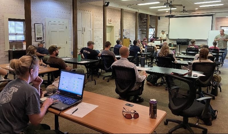
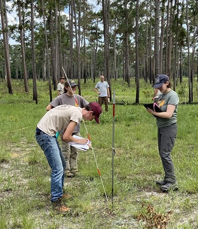
Long-term data sets are the bread and butter of the Tall Timbers Game Bird Program. Our long-term data sets for radio-tagged quail from the Red Hills, Albany and now Central Florida allow us to monitor different bobwhite populations and how they function. However, we often find ourselves lost in the numbers without focusing on the bigger picture. One major takeaway from looking at these data is that not all high density and stable populations are created in the same way. There has been an ongoing debate among quail biologists in recent years about which demographic is most important: adult survival, reproductive output, male contribution to re-production, or brood survival. We believe the answer is all of the above, and that it can vary from place to place, and even year to year on the same place.

In the Red Hills region of north Florida and south Georgia, overwinter survival on our two study areas (Tall Timbers & Livingston Place) has averaged about 45% since 2014, com-pared to 62% in Albany and 58% on Escape Ranch in Central Florida within the same time period (Figure 1a, b, c, d).

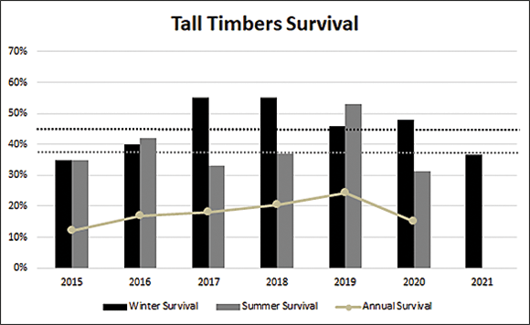
1a. Seasonal and Annual Survival of radio-tagged quail on Tall Timbers near Tallahassee, FL from 2015–2021 compared to the average for the same time period.

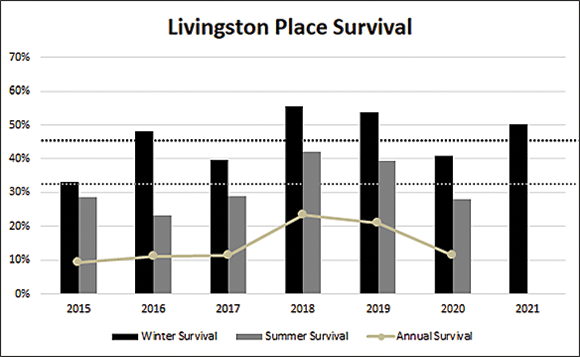
1b. Seasonal and Annual survival of radio-tagged quail on Livingston Place near Monticello, FL from 2015–2021 compared to the average for the same time period.

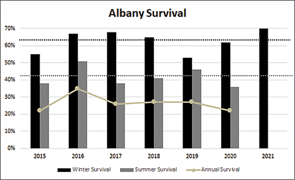
1c. Seasonal and Annual survival in Albany, Ga from 2015-2021 compared to the average for the same time period.

1d. Seasonal and Annual survival on Escape Ranch from 2018-2021 compared to the average for the same time period

However, Escape Ranch is currently a unique situation in that management intensity has dramatically increased over the past 4 years resulting in high survival and reproductive demographics typical of an increasing population.

Nonetheless, lower overwinter survival, as seen in the Red Hills, creates a situation where higher levels of production are typically required to maintain an overall high-density stable population. In Albany, such high production is not always necessary, because overwinter survival is typically higher. So, what does that actually mean? This means per capita production must be higher in the Red Hills to produce a density similar to that of the previous year (and hopefully higher!).

This year’s Red Hills population is being built on a “carry-over” percentage into the spring that was slightly above average on Livingston Place, but well below average on Tall Timbers. Luckily, at the mid-point of the breeding season, female per capita nest and brood production was above average on Tall Timbers and Livingston Place (Figure 2 a, b).

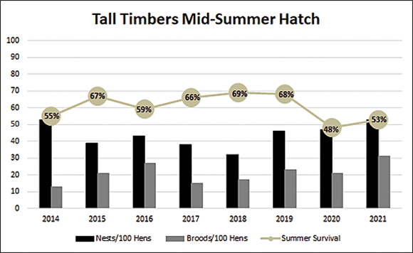
2a. Tall Timbers mid-summer adult survival and nests and broods/100 hens on July 15, 2014-2021.

2b. Livingston Place mid-summer adult survival and nests and broods/100 hens on July 15, 2014-2021

As we discussed in last year’s Quail Call, high male incubation rates are an excellent indicator of strong production. Male contribution has been above average this year on both Tall Timbers and Livingston Place. In fact, between Tall Timbers and Livingston Place approximately 28% of the males in our radio-sample have incubated a nest, compared to only 8% on our Albany site. Again, not all stable populations are created in the same way. Adult survival in the Red Hills was above average on Livingston Place, but below average on Tall Timbers at the mid-point of the breeding season. The excellent early hatch on Tall Timbers and above average survival on Livingston Place provide reason for optimism heading into the second half of the breeding season. Additionally, chick and brood survival have been good due to timely rains and lack of significant weather events. However, while all of this information can produce a fall forecast, there is still time for things to change. The second half of the breeding season is critical for the fall, as these chicks make up the highest proportion of fall juveniles. We will continue to monitor throughout the remainder of the breeding season, to provide a final update and continue to understand and paint the picture for how these different populations maintain stability from year to year.

This year’s Albany population is being built upon above average carry-over from what were near record bird densities last fall. The populations in Albany have been on a pretty good run since the last summer drought in 2014, and are apparently still benefiting from the new ground effect following the cleanup from tornadoes in 2017, and hurricane Michael in 2018. Our study site is also benefiting from removal of predator habitat by thinning young pine stands and removing snags, as well as from observing high cotton rat numbers following intensification of coyote and bobcat trapping.

These factors all contributed to 70% overwinter survival coming into spring 2021, which is above the 62% average shown on the graph, and well above our 30-year long term average of 52%. In fact, on April 1 of this year, we documented the record high spring breeding density for the 30 years we have monitored this population. As our President & CEO Bill Palmer likes to say about the region’s property managers, “these folks have gotten really good at keeping quail alive.”

At the midpoint of the nesting season in Albany, female nest per capita is well above average for the time period shown Figure 2c), while brood production per capita is only slightly above average. As mentioned previously, male contribution is low in Albany with less than 10% of males incubating a nest, but this is normal for this population in most years. Summer adult survival is also well above average, which is good news for the second half of the breeding season, and reason for cautious optimism. We will continue to monitor these birds throughout the summer and report on the final hatch numbers in early October.

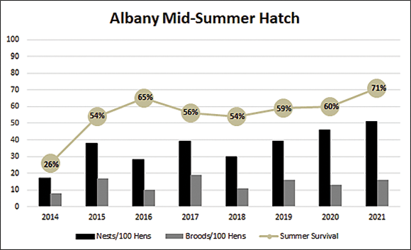
2c. Albany mid-summer adult survival and nests and broods/100 hens on July 15, 2014-2021.

This year marks the fourth breeding season we have had radio-tagged birds on Escape Ranch in central Florida. Central Florida quail operate under a slightly different calendar. What we typically consider the mid-season hatch in Albany and the Red Hills (July 15), is more representative of the latter half of the breeding season in central Florida. Quail in this population typically begin the breeding season in late February or early March, (the first detected nest on Escape Ranch started incubating on March 18th), and hatch their final nests in late August to early September.

While percentage carry-over was below average for this site, high densities the previous fall still resulted in good numbers of potential breeders heading into the spring of 2021. Escape Ranch saw a strong start to the breeding season, with above average female per capita nest production and average per capita brood production (Figure 2d).

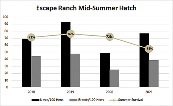
2d. Escape Ranch mid-summer adult survival and nests and broods/100 hens on July 15, 2018-2021

Additionally, brood survival has been excellent thus far due to a delayed start of the rainy season in central Florida. Male contribution this year in the central Florida population is similar to what we see in the Red Hills (~20% have incubated a nest), and is indicative of strong production. At the mid-season mark, adult survival is considerably lower than average. However, the late season rains characteristic of central Florida, should improve cover conditions and ultimately have a positive effect on adult survival, facilitating late season productivity. As with our other sites, we will continue to monitor this population and provide a final report at the end of the breeding season.

Fire Modeling with California Partners

Fire Modeling with California Partners

Fire Modeling Leaps Forward with California Partners

Computer models using artificial intelligence, predicting fire behavior, adjusting for atmospheric feedback and ignition patterns may sound out of place for some long-time burners in the Southeast. However, these new tools and technology are critical for planning and supporting decisions to reintroduce fire in complex settings and to supplement training for the workforce needed to maintain and bring back “good fires” across our country.

Tall Timbers Fire Scientists Kevin Hiers and Daniel Rosales-Giron, with Board Member and Los Alamos National Laboratory Senior Scientist Dr. Rod Linn, were at the center of a partnership to complete QUIC-Fire in 2020. As the first of these new coupled fire-atmosphere models that does not require a super computer, QUIC-Fire quickly gained attention for applied uses.

The new WIFIRE Lab based at the San Diego Supercomputer Center of the University of California, San Diego has now integrated QUIC-Fire as the model behind its new decision support tool BurnPro3D. WIFIRE has an impressive team of partners focused on advancing data, computing and workflows to tackle the knowledge needs surrounding a wide variety of hazards.

WIFIRE Lab Founder and Principal Investigator Dr. Ilkay Altintas is the Chief Data Science Officer at the San Diego Supercomputer Center. Dr. Rod Linn and Kevin Hiers are both Co-Principal Investigators and Co-Leads for Fire Science on the project. With first year funding of $900,000 from the National Science Foundation and a $5 million phase two proposal pending, WIFIRE is positioned to provide the “cyberinfrastructure” needed to continue developing usable decision support and training tools to expand the use of prescribed fire.

“WIFIRE is exactly the type of technology initiative that Tall Timbers and our partners have been looking for to take our fire science research and leap forward to the fire tools of the future,” explains Hiers. “This is the collaborative approach across disciplines that can get us to big ideas like the ensemble model runs you see for hurricane planning and flight simulators for pilot training. These are now rapidly approaching concepts for prescribed fire planning and training.”

WIFIRE Lab hosts both WIFIRE Commons as a collaborative platform and BurnPro3D as the new decision support tool driven by QUIC-Fire. Additional information on each of these WIFIRE projects follow. You can also visit the WIFIRE Lab website and subscribe to the WIFIRE Lab’s YouTube channel for the latest news, updates and project videos. Tall Timbers will continue to share more with you as this exciting effort moves forward.

WIFIRE Commons is the WIFIRE Lab’s collaborative platform that enables the development of AI-driven societal and scientific wildland fire applications through data and model sharing. The primary objective of the Commons is to create a convergence environment to accelerate wildland fire science and its proactive application to operational use for mitigation, planning, response, and recovery, through AI innovations. To achieve convergence between the AI and fire science communities, WIFIRE Commons develops an intelligent and integrated infrastructure to catalog, curate, exchange, analyze, optimize, and communicate big data and models at scale.

BurnPro3d is a decision support tool, created by the WIFIRE Lab, that harnesses novel ensemble simulations, using a new coupled fire-atmosphere model (QUIC-Fire), to capture the interaction between user-defined complex ignition patterns. BurnPro3D is the only space for active collaboration among land managers, burn bosses, plan approvers, and policy makers that will significantly increase the proactive application of fire in order to successfully combat devastating megafires. Additionally, in fire mitigation and response, BurnPro3D supports users in communicating risks and trade-offs to regulators and the public.

New Shortleaf Pine-Oak-Hickory Study

New Shortleaf Pine-Oak-Hickory Study

Shortleaf pine-oak-hickory long-term study begins

The Fire Ecology and Fire Science labs have initiated a new long-term project to track forest community changes in a native shortleaf pine-oak-hickory community on Tall Timbers Research Station. This natural community type, regionally less well known than the longleaf pine-wiregrass community, has an open canopy of shortleaf pine and upland fire-loving hardwood trees such as mockernut hickory, post oak, southern red oak, white oak, and black oak. The main grass species is little bluestem grass instead of wiregrass, but the community shares a lot of native groundcover indicator species with longleaf pine-wiregrass habitats.

The new study site is in the northwestern quarter of Tall Timbers on the Atkinson Course, also known as the Scrub Course or Jones Course. The Fire Science Lab made terrestrial-based LIDAR scans to create a map of apparent tree locations. The Fire Ecology Lab confirmed locations of larger trees in the field, tagged them, and used them to map smaller trees greater than 2 cm diameter at breast height within a 4-hectare (10-acre) area.

Part of the new map of trees for a long-term study of the shortleaf pine-oak-hickory native community at Tall Timbers Research Station.

The trees will be remapped at two-year intervals to gain knowledge about growth and regeneration of trees in this community type, including the effects of fuel loads and fire on tree recruitment. The new knowledge will be valuable since very little is known about this community type in the Red Hills Region and shortleaf pine ecology in general.

Intern Angela Seibert uses a siting compass to map smaller trees. Other interns conducting the mapping this summer were Makayla Timms and Genevieve Printiss. Photo by Genevieve Printiss

Frosted Elfin Butterfly Study Glows

Frosted Elfin Butterfly Study Glows

Going with the glow

Things that fluoresce under blacklight: the security thread in $100 bill, a forged “Old Master” painting, those groovy posters from the 70s, and the caterpillar of the frosted elfin butterfly.

In fact, according to a paper published by David Moskowitz of Rutgers University, “Many caterpillar species fluoresce, or at least stand out brightly against the background, when exposed to ultraviolet light.”

a green caterpillar at the end of a plant stem

A glow worm IRL: a frosted elfin caterpillar fluoresces under ultraviolet light.

Moskowitz’s 2019 study documented promising results from trials using ultraviolet, or UV, flashlights to survey for frosted elfin caterpillars at night.

Last year, U.S. Fish and Wildlife Service fellowship biologist Ryan Bell picked up the torch.

Using the findings from the study, he developed a standard blacklight-survey protocol for partners who are helping to look for the rare butterfly across its native range, which spans from Florida west to Texas, and north to the Great Lakes states.

The blacklight surveys for caterpillars don’t replace the surveys for adults during their flight period, which have taken place range-wide since 2019. Rather, they offer a way to make up for missed opportunities. Maybe you couldn’t get to a survey site during the flight period — only about a two-week window in the spring. Or maybe you were at a site during the flight period, but didn’t see any frosted elfin because it was raining.

“They have such a wide range and limited flight window, it can be hard to have people on the ground in the exact right location, at the right time,” Bell explained. “Adding UV light lets us extend surveys three weeks beyond the flight period.”

The leaves on a bush appears purple under blacklight

Can you spot the glow worm in this photo?

This summer, the Service’s Science Rapid Response Team, which comprises up to 12 fellowship biologists (including Bell), piloted the approach at sites in Massachusetts, Connecticut, and Rhode Island. The team is engaged in collecting new data to understand the status of a number of species, like the frosted elfin, that appear to be in decline.

Did it work? Fellowship biologist Kathryn Nolan pointed to their experience at The Nature Conservancy’s Carter Preserve in Rhode Island, where they looked for frosted elfin during the adults’ flight period to no avail.

When they went back a couple of weeks later to search after dark using blacklights, she said, “I could see caterpillars glowing from six feet away.”

Light my fire

Partners are using the blacklight survey method, too, including in northern Florida at the Apalachicola National Forest, home to one of the largest known populations of frosted elfin in its range.

“When you have a whole forest to search through, blacklight may be the most efficient way to look for these guys,” said Robert Meyer of Tall Timbers, a research station and land conservancy based in Tallahassee, about 50 miles northeast of Apalachicola.

He had a hunch blacklight would be an efficient way to gather other information on the species, too.

Meyer specializes in red cockaded woodpecker conservation, but because frosted-elfin activity falls outside the breeding season for this bird, he saw an opportunity to contribute to research needs for the butterfly.

“We have the best population of the species an hour away from the station, why shouldn’t we help out?” he said. “Especially because the species will be up for Endangered Species Act consideration in a couple of years. This is the best time to gather information.”

A brown butterfly with colored spots on its wings

A male frosted elfin butterfly that researchers captured and marked with colored dots. The pattern is a key to where in the forest he was found. Dave McElveen/Tall Timbers

Meyer and colleague Dave McElveen submitted a research proposal to the U.S. Fish and Wildlife Service and the Fish and Wildlife Foundation of Florida (funded through sales of the Conserve Wildlife license plate) to investigate several key issues for managing frosted elfin populations across their range. Their research spans the spectrum, from capturing, marking, and recapturing adults to see how far they disperse — and if they will disperse cross a utility line corridor — to experimenting with novel techniques for distinguishing frosted elfin caterpillars from those of the gray hairstreak, a look-a-like species.

One of the research questions relates to pupation — the stage when butterflies transform from caterpillars to adults. Although the frosted elfin spends the majority of its life as a pupa, scientists don’t know much about what the species looks for in a pupation site.

Knowing where they prefer to pupate could directly inform decisions about habitat management, especially because their habitat requires periodic disturbance. Frosted elfin depend upon wild lupine and wild indigo, plants that grow in fire-tolerant oak-pine barrens, oak savannas, prairie, and dry oak woodlands.

“We know pupa have a tendency to bury themselves, but we want to know where, and how that influences whether they survive fire,” Meyer said. “Maybe there’s something we can do about the environment to increase their potential to survive when we burn.”

Because using prescribed fire to restore frosted-elfin habitat is key to ensuring a future for the species, understanding the potential for pupa to survive fire will help managers use this approach effectively.

To investigate the caterpillars’ pupation preferences, the researchers decided to follow them. That’s where the blacklight comes in.

Although the caterpillars glow on their own, Meyer and McElveen proposed coating them with hot pink biodegradable UV fluorescent powder so they would also leave a glowing trail behind them on the forest floor.

A caterpillar painted with UV powder glows pink in the dark under blacklight

A “pinked up” caterpillar, painted with biodegradable UV fluorescent powder, stands out in the dark under blacklight. Dave McElveen/Tall Timbers

“When we’d see a caterpillar munching on some lupine in the daytime, we’d go over and pink them up, and then come back at night to follow the little breadcrumb trail of powder to see where they went,” Meyer explained.

While the tracking method worked, they didn’t find what they expected at the end of the hot-pink trails.

“We found a lot of shriveled bodies with puncture wounds,” Meyer said, explaining that spider populations tend to boom a few years after an area has been treated with fire.

Fortunately the trail wasn’t completely cold. They did find some pupa that evaded spiders and buried themselves just below the surface of the sand or tucked themselves into a bit of grass.

“My running hypothesis is that they look for someplace dark,” Meyer said.

That could mean the ideal pupation habitat is about two years after a burn, when vegetation is still sparse enough that the caterpillars need to dig down a bit to feel secure, rather than just hiding under a leaf or a pinecone leaving them susceptible to both fire and predation.

They’ll need more data to reach a conclusion, but there’s always next season to pick up the trail. And blacklight will help shed light on the issue.

The effort to conserve at-risk wildlife and recover listed species is led by the Service and state wildlife agencies in partnership with other government agencies, private landowners, conservation groups, tribes, businesses, utilities, and others. It has drawn support for its use of incentives and flexibilities to conserve rare wildlife, reduce regulations, and keep working lands working.

This article is courtesy of the author, Bridget Macdonald and first appeared August 10 in Medium/Conserving the Nature of the Northeast.

LiDAR Habitat Survey Technique

LiDAR Habitat Survey Technique

Using Terrestrial LiDAR to Survey Habitat Conditions

For the second summer in a row, Tall Timbers collaborated with the US Fish & Wildlife Service (FWS) to collect terrestrial LiDAR data and examine its use as a field monitoring technique. This interagency terrestrial LiDAR project dispersed six fellows across three states in the southeast region to gather data. These locations included St. Marks National Wildlife Refuge (NWR) (St. Marks, Florida), Piedmont NWR (Hillsboro, Georgia), and across the Francis Marion & Sumter National Forest ranger districts (South Carolina). The data collected will not only benefit those sites, but will also allow for a refinement of the overall protocol and development of the capabilities of the technology. This new surveying method will provide a range of data and products that will aid in land management decisions, as it can monitor landscapes rather than isolated ecosystem properties.

US Fish and Wildlife LiDAR monitoring field team including FWS Directors Fellows; Top left Laila Lienesch, Hugh O’connor (Fellow), Jon Wallace, Evan Monnet (Fellow), Konnor Larkin, Scott Pokswinski; Bottom left Jennah Ruebens (Fellow), Molly Dixon (Fellow), Calista Hnilica (Fellow).

The fellows were given this opportunity through the Directors Fellowship Program. The program provides college students, both undergraduate and graduate, experience working on projects that promote and support the conservation priorities of FWS.

US Fish and Wildlife and US Forest Service employees undergo terrestrial LiDAR monitoring training at Tall Timbers under the Direction of Scott Pokswinski and Jon Wallace.

US Fish and Wildlife and US Forest Service employees undergo terrestrial LiDAR monitoring training at Tall Timbers under the Direction of Scott Pokswinski and Jon Wallace.

The summer began with training at Tall Timbers lead by Scott Pokswinski. Representatives from each location were in attendance to further learn about the process and meet the fellows involved. The two days of training consisted of field technique demonstrations and some of the data development. The fellows then departed from Tall Timbers in teams of two to their assigned sites. Over the next eight weeks the teams trekked through a variety of forest habitats, scanning plots. There were many challenges encountered, ranging from the physical field work, such as maneuvering extreme topography or dense foliage, to the capabilities of the software, including misidentifying telephone poles as trees. It was because of these challenges that inquires have been made and aspects of the process have been improved. At the end of the fellowship program, the project accumulated data from 670 plots.

This interagency terrestrial LiDAR project aims to explore the potential of using terrestrial LiDAR as a plot surveying method. This new use of terrestrial LiDAR technology promotes an increase in monitoring efficiency, while expending less resources. The training required for the field aspect is very straight forward and can easily be learned by individuals without surveying or fieldwork experience. Possible products from these scans include basal area, height to live crown, timber volumes, and fire fuels data. The project is also working towards machine learning to identify fuel loads in LiDAR scans.

The resulting data should inform recipients of the state of the habitat. These outputs are predicted to benefit a variety of interests, especially those related to management. These new techniques may be a way to monitor a habitat’s condition before and after a treatment or natural event. As conditions are better understood and documented through LiDAR, there should be better representation of habitat objectives and what steps should be taken to accomplish objectives including applications for prescribed fire planning and implementation.

The next steps for the project will be processing the data from the plots and extracting useable results. These results will be beneficial in habitat decision making and monitoring, leading to more strategic habitat conservation efforts.

The project would like to thank the fellows for their dedication this summer. The support provided from St. Marks NWR, Piedmont NWR, and the Francis Marion & Sumter National Forest ranger districts is greatly appreciated.