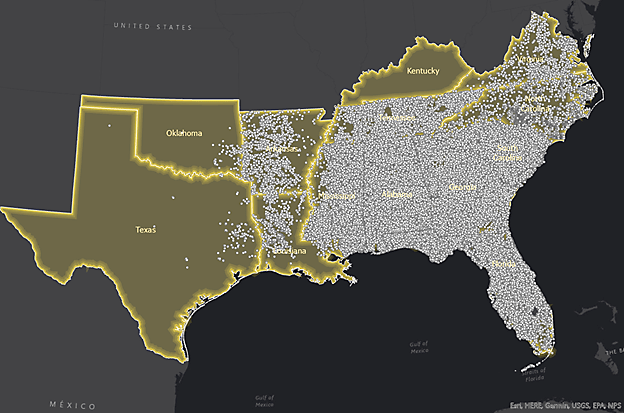
Quail Hatch Report in Anticipation of Quail Season
As the 2021 breeding season came to an end, the anticipation of quail season was beginning to build. This summer the Tall Timbers’ Game Bird Program monitored breeding season demographics from a combined 1,152 radio-tagged birds from the Albany, Red Hills, and Central Florida regions.
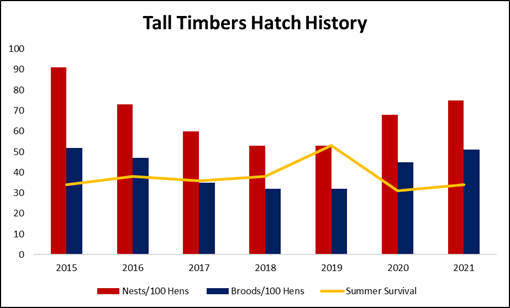
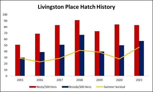
Red Hills
Here in the Red Hills, there was reason for “cautious optimism” heading into the fall. Per capita female nest production was approximately 10% above average, and per capita brood production was approximately 15-20% above average across both of our study sites in the Red Hills, dating back to 2015. Male contribution was significant this year, as approximately 31% of our radio-tagged males in the Red Hills incubated a nest. Additionally, we documented a fairly strong late hatch, as 40% of all our recorded broods hatched after July 15, on both Tall Timbers and Livingston Place. This is encouraging given the late hatch is critical to fall populations. We documented summer survival well above average at Livingston Place (in fact record summer survival), compared to slightly below average survival at Tall Timbers. However, excellent cover conditions contributed to seemingly good chick survival, which, coupled with above average brood production, allowed us to feel encouraged heading into the fall.
That being said, as we navigated through the many covey call counts across properties of the Red Hills, a few interesting trends began to develop. We all knew we’d had a wet summer, but the central and western portions of the Red Hills appear to have been affected by the rains more so than properties in the eastern portion of the region, with a few exceptions. Untimely, isolated rain events can be detrimental to quail chicks, especially when these rains occur at night. After talking with many managers across the central and western portions of the region, many believe this is what happened. This explains in part, why quail densities across the central and western Red Hills appear to be down on average 20%, compared to last year. Tall Timbers has not been immune to this trend, as densities appear to be slightly down from last year as well.
As we move east across the Red Hills, the narrative begins to change. Properties in the eastern portion of the region appear to have been less affected by untimely rainfall and densities, on average, are similar or slightly up from last year. This trend compliments what we saw with our radio-marked birds on Livingston Place in the eastern Red Hills, as well as the density estimates across the property.
Often times, a population decrease is the result of weather and is out of our control. Fortunately, quail have a knack for bouncing back. Although any population decrease is discouraging, it is important to keep in mind that the Red Hills still hosts some of the highest bobwhite densities in the country, and this is a testament to the intensive management implemented by the highly-skilled managers throughout the region. The only thing left to do now is turn a dog loose and get out there. The best time of the year is upon us, and we am looking forward to seeing how the season unfolds.
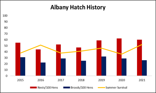
Albany
Even with very good adult survival, per capita nest and brood production by radio-tagged hens in Albany were only about average for the 2021 nesting season. Male contribution to reproduction was also low, with less than 10% of males incubating a nest. While on the surface this does not sound like great news, this reflects very high population densities, and what we call “density dependent reproduction.” The full story begins with last fall’s populations in Albany, which were at or near record levels, and the overwinter survival or “carry-over” from them. In fact, in 2021, we documented the highest spring breeding population we have had during the 30 years of monitoring this population with a density of 2 birds/acre on April 1. This was followed by very good summer adult survival, and produced an end result of the highest annual survival we have ever recorded. Our annual survival (Oct 1, 2020 – Sept 30, 2021) was an unprecedented 37%, which means there is a little over 1 bird/acre still alive from last fall’s population.
The 2020 hunting season was put in the record books for many properties across the region, and most managers would have signed a lifetime contract to match the coveys per hour seen last year. Being that we are coming out of summer with great growing conditions, extremely high carryover, and even higher hopes, how this would all shake out in the fall population was on everyone’s mind. Over the past month, we completed fall covey counts on 20+ properties in the Albany area—what we have seen has been very encouraging. While we haven’t seen very many properties with huge gains or losses either way, most places are looking just as good or are slightly higher than last year’s population. This is promising considering the great numbers we saw last year. However, as many of you know, just because you have high densities coming into the season, you still need the weather, the dogs, and the birds to cooperate. We are hopeful to get some early frosts and rain, throughout the next month, to make them easier to find later in the season. While things in the quail woods around Albany look promising, we are cautiously optimistic as always. We love seeing the end product of the hard work that is done in the other 8 months of the year, and we are excited to hear how your season progresses.
Alabama
Mark Sasser, Tall Timbers regional game bird biologist for Alabama, reports that after the fall covey census work was completed on all cooperating properties, the quail population is very good this year. Surveys recorded stable or increasing populations from properties scattered across the state, from the Mobile area to the Birmingham area. The translocation site in north Alabama, Triple Creek Farm, located in St. Clair County, was the largest increase at 53%.
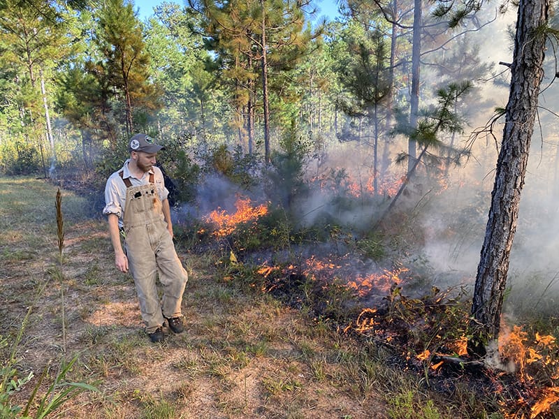
Tall Timbers Season of Fire Study at New Research Plots
By Kevin Robertson, Fire Ecology Program Director
Throughout the years, we have often been asked for guidance regarding the effects of season of fire on various aspects of upland pine communities, including woody plant re-sprouting, value for wildlife habitat, flowering of native plant species, effects on pine tree growth and survival, and ease of burning, to name a few. Much of our prior research has focused simply on dormant season versus growing season burning. At the beginning of this year, we worked with Tall Timbers’ Land Management and Administration staff to set up long-term research plots on Tall Timbers that we have begun to burn in winter (December–January), spring (March–April), summer (June–July), and fall (September–October), to more closely study seasonal effects of fire. The plots are in shortleaf pine native groundcover, but within one-acre areas that were planted with longleaf pine in the late 1990s.
The Fire Ecology Lab’s primary interest in the project was to better understand seasonal effects of fire on woody plant re-sprouting vigor, and survival of whole plants to help managers use season of fire as a tool for adjusting woody plant dominance. However, several additional research projects have sprung from the plots. University of Florida doctoral student David Mason is using them to study the role of season of fire in attracting birds that disperse seeds of plants that are fruiting at that time, which may influence plant species composition through “directed dispersal.” University of Florida master’s student Emma Zeitler is using the plots to test the effects of season of fire on intensity of deer browse on re-sprouting woody plants. She is also investigating fire timing effects on dung beetle activity and resulting patterns of seed dispersal.
Doctoral student David Mason inspects an October burn in one of the new research plots.
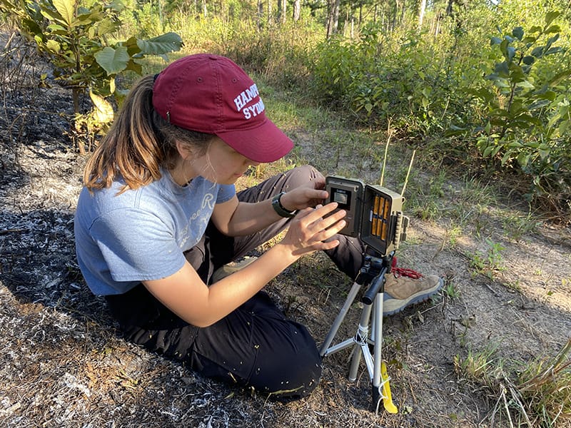
Masters student Emma Zeitler sets up a trail cam to monitor deer browse following fall fire.
Research Director Morgan Varner and postdoc Timothy Shearman are using the plots to study seasonal effects of prescribed fire crown scorch of longleaf pine growth and survival. Forest Service entomologist Michael Ulyshen plans to use the plots to study seasonal fire effects on use by bee pollinators and bee community composition. The Fire Ecology Lab is also planning a long-term project to track timing of flowering in response to timing of fires. We look forward to learning a great deal from the plots through collaboration among a great group of interested scientists.
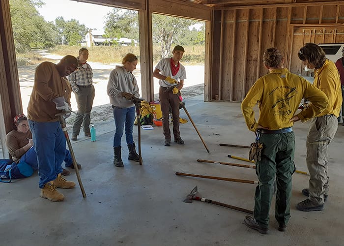
Fire training grows to help meet regional and national needs
By Matt Snider, Wildland Fire Specialist
Many of our planet’s diverse habitats and species have co-evolved with fire over millennia, with humans picking up the torch thousands of years ago to begin living with fire. While you may often see news stories that focus on out-of-control wildfires threatening homes and forests, there are many positive fire stories to be found here at Tall Timbers.
Part of the solution for humans to coexist with fire once again is to build a diverse and nimble fire workforce that not only fights fire, but lights fire as well. Tall Timbers is deeply engaged in collaborative wildland fire training to address this urgent need.
“There is a need for a highly skilled and agile organization like Tall Timbers to jump in and help with these training needs. We see this in our state partnerships from Florida up through the Mid-Atlantic and New England, in our national work with agencies like the Department of Defense and the U.S. Fish and Wildlife Service, and as the host site for the National Interagency Prescribed Fire Training Center,” explains Matt Snider, Fire Training Specialist at Tall Timbers.
Tall Timbers currently employs three full time and nine part time employees whose primary focus is wildland fire training. Working in both classroom and field settings, these staff members help advance the knowledge and skills of professional wildland fire managers and private landowners across the country.
Sharpening tools
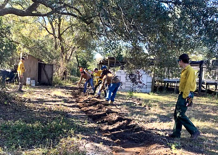
Through our association with the University of Florida and The Natural Areas Training Academy, our staff delivers National Wildfire Coordinating Group sanctioned curriculum to federal, state, and local fire managers who work to enhance the safety and efficiency of both prescribed fire operations and wildland fire response.
A partnership with the Florida Fish and Wildlife Conservation Commission allows us to deliver risk management workshops and hands-on, field-based prescribed fire training to private landowners and members of prescribed burn associations, which encourages the safe, efficient use of ecologically sound fire as a land management tool.
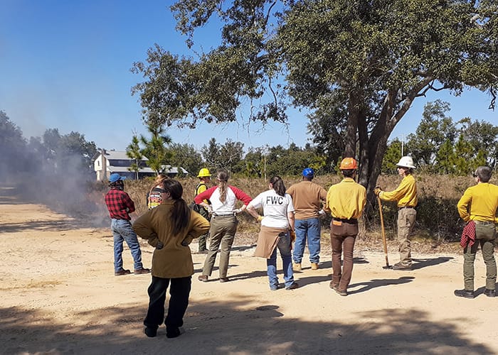
Live fire demonstration
We work closely with professional fire managers in the New England and Mid-Atlantic states to identify critical fire training needs and develop solutions, such as new academies and the development of demonstration sites, where students, fire managers, and private landowners can learn and practice prescribed fire skills in an environment that allows for hands-on learning in a low risk environment.
Tall Timbers is now also the host site for the National Interagency Prescribed Fire Training Center (PFTC), a center of prescribed fire excellence that is a cooperative venture between the U.S. Fish and Wildlife Service, the U. S. Forest Service, and Tall Timbers.
“PFTC has hosted students from across the country and globe to come to the Southeastern U.S. to learn about and experience prescribed fire. There have been attendees from all 50 states, and 18 foreign countries— from Australia to Trinidad.” Says Greg Seamon, Tall Timbers PFTC Training Specialist.
In collaboration with the Department of Defense (DOD) and the U.S. Fish and Wildlife Service, Tall Timbers helps to provide classroom and field-based skills training to civilian employees on DOD lands. DOD lands are hotspots of biodiversity and our cadre of instructors is helping to keep safe, reliable fire working for the benefit of these natural communities held in the public trust.
The training staff at Tall Timbers are committed, experienced fire professionals who believe that accomplishments in wildland fire management education and mentoring are realized when fire managers, private landowners, and training professionals come together to ensure that the right fire, is applied at the right time, on the right landscape to achieve outcomes that benefit the public and natural communities.
As the tide rose, the salt flats became stickier to walk through, increasing the effort required for each step. The physical exertion was antithetical to the view before me—an expansive marsh with gradients of green grasses and sedges winding through the salt pannes, bursting with songs of Seaside Sparrows and Red-winged Blackbirds. Wading birds and shorebirds foraged in mixed flocks where water was beginning to pool. After taking a moment to drink some water and enjoy the scene before me, I trudged on—only about 250 meters until I got to the truck.
A high marsh habitat with glasswort in the foreground and black needlerush in the background. These systems require fire to prevent encroachment by woody shrubs and maintain an open, grassy setting.
That’s when I heard it. After searching for nearly six weeks, I was starting to lose hope I’d ever hear the elusive and threatened Black Rail. But, in a patch of short black needlerush, one began to ‘kickeedoo’ incessantly for nearly two minutes straight. I was beside myself. This was the first Black Rail I had ever heard. It was just one of many birds we heard last summer.
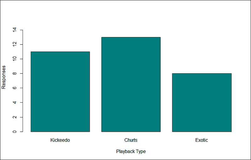
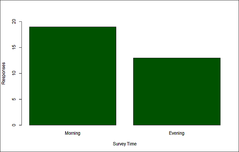
In 2020, we joined the efforts of the NOAA RESTORE Firebird project (Firebird), which seeks to understand the influences of high marsh management—specifically prescribed fire—on Black and Yellow Rails along the northern Gulf of Mexico coastline. The Eastern Black Rail, the subspecies that occurs in the eastern half of the United States, was listed as threatened under the Endangered Species Act last year. We completed a pilot season in 2021, to locate areas occupied by Black Rails in the region and to identify the most efficient survey methods. Our efforts were focused on high marsh habitats, the area nestled in between the mucky, low marshes and the uplands which are infrequently inundated with water. For our surveys, we tested the effects of different playback types, time of day, wind speed, lunar phase, and barometric pressure on responses.
After we finished surveys in late July, we used occupancy models to determine detection probability, or the likelihood of detecting an individual on a single visit. Occupancy models are ideal for species like the Black Rail because they account for imperfect detection. Within candidate models, we incorporated covariates that included environmental factors, such as wind and temperature that were measured at the start of each survey. We also included the type of playback used in addition to the time of the survey; the two factors we were especially interested in. We then ranked models to determine which factors affected Black Rail detections.
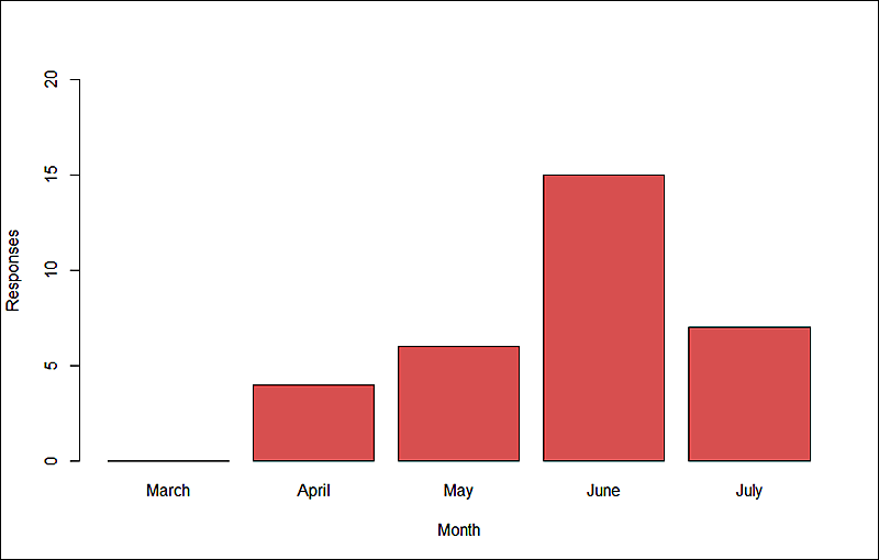
We made a total of 900 visits to the 147 sites between March 15 and July 31. Black Rails were first heard in early April, but responses peaked in June (Figure 1). The probability of detecting a Black Rail on any given survey was 0.21 ± 0.05. Across the 147 sites, 0.15 were occupied. Ranked models indicated that no one factor was especially important for determining occupancy and there were no significant effects regarding playback type (Figure 2) or survey time (Figure 3), two factors we were especially interested in.
Figure 1: Seasonal responses of Black Rails during the 2021 breeding season.
Figure 2: Black Rail responses according to 3 different playback call types.
Figure 3: Black Rail responses according to time of day.
Our detection and occupancy results were on par with other studies, and although we didn’t learn very much from the individual models, we came out with a lot of practical knowledge about Black Rail habitat, behavior, and vocal patterns in the Big Bend region that will inform our survey efforts for the next several years as we continue to unfurl the secretive ways of the Black Rail.
Prescribed fire is an important tool across ecosystems to reduce wildfire hazard, maintain fire-prone ecosystems, manage threatened and endangered species, and improve wildlife habitat. Increasing the pace and scale of prescribed burns for fuels management is a major priority to reduce wildfire intensity that endanger communities and disturb habitats. The purpose of the Southeastern Burn Geodatabase Project is to map and analyze the frequency of prescribed burns throughout the Southeast.
Photo Courtesy of the Prescribed Fire Training Center (PFTC).
Tall Timbers collected information on how permit location is tracked in the Southeast including what attributes are collected, spatial characteristics, period of record, and data stewardship. Prescribed burn data was then requested from twelve Southeastern states for the 2010-2020 time period, which was then loaded into a database with standardized minimal attributes.
Prescribed burn data collected from the Southeastern states.
Tall Timbers is using this data for a multi-state database, with timely and informative burn data throughout the Southeast United States. This database could also be used by public and private land managers to prioritize areas for treatment with prescribed fire, as well as by scientists and policy-makers, to help answer a variety of questions as we all work to expand the pace and scale of prescribed fire use.
Heat Map of all Burn data (2010-2020) in the Southeast showing the density of burn points, weighted by acreage.
While there are limitations to this data, the burn authorizations are a rich dataset, which can be used in a spatial database as ancillary data for analyses that will further our understanding of prescribed fire occurrence and characteristics. The ultimate goal is to assist prescribed burn practitioners to make better decisions in prioritizing areas of treatment. Capturing the prescribed burn patterns in each of the Southern states may reveal patterns of opportunities and limitations—time of day, seasonality, topography, and cultural preferences.
Special Thanks go to: Alabama Forestry Commission, Arkansas Forestry Commission, Florida Forest Service, Georgia Forestry Commission, Kentucky Division of Forestry, Louisiana Department of Agriculture and Forestry, Mississippi Forestry Commission, North Carolina Forest Service, Oklahoma Forestry Services, South Carolina Forestry Commission, Tennessee Division of Forestry, Texas A&M Forest Service, Virginia Department of Forestry, Fort Benning, and Kisatchie National Forest.
The M-CORES program, which includes the proposed Suncoast Connector Toll Road in Jefferson County, passed through the Florida Legislature at breakneck speed with little review or analysis. Tall Timbers has a number of concerns given the potential for significant and wide spread impacts. These include fragmenting public and private conservation lands, robbing business from Main Street Monticello, impacting our rivers and other water resources, and making prescribed fire more difficult and costly.
Join us in asking the Jefferson County Board of County Commissioners to OPPOSE the Suncoast Connector toll road and its path through Jefferson County.
Take action now with our easy email form.
Send an email to all five Jefferson County Board of County Commissioners with one click!
Burn prioritization modeling seminars and fire modeling tools are supported by Wildland Fire Science to train managers in the important planning stages of prescribed fires.
Educating and guiding the next generation of fire researchers and managers is a key goal of Wildland Fire Science and a resource for testing new ideas in fire research.
Tall Timbers hosts the premier fire technology transfer organization—the Southern Fire Exchange. This JFSP funded effort helps connect research to management through webinars, workshops, and support of the Prescribed Fire Science Consortium.
Working with partners in the Prescribed Fire Science Consortium, the program is building nexgen 3-D fuel beds using terrestrial LiDAR and novel sampling techniques to power new fire behavior models for prescribed fire managers. This work links to Tall Timbers work in wildlife habitat usage and ecological forestry.
The Longleaf Legacy landscape prescribed fire burn team arm of Wildland Fire Science works directly with landowners and partners to effectively put fire on the ground and promote prescribed fire throughout the region.
Tall Timbers is leading an effort to map fire regimes at the landscape scale. Staff work with numerous agencies to evaluate fire records and satellite imagery to build this critical conservation database. https://skfb.ly/6DqOY
Tall Timbers hosts the Prescribed Fire Science Consortium, a national network of researchers and managers who promote integrated research and management to advance next generation tools for fire practitioners. https://arcg.is/1DSjDT
We are linking physics and field observations to understand the fluid dynamics of fire behavior surface fire regimes. Our work combines field observations using advanced thermal imaging techniques, laboratory studies, and coupled fire-atmospheric modeling to help managers improve outcomes of managed fire regimes.
Selected Publications authored by Wildland Fire Science staff.
Staff and researchers support Federal fire training by serving as a cadre for NWCG training courses, ranging from basic wildland fire to advanced fire effects.
(PFTC) specializes in training fire fighters the principles and techniques of prescribed fire through practical hands-on experience. https://www.fws.gov/fire/pftc/
Private land owners are the largest source of prescribed fire in the country. These land owners and the culture of fire that was maintained by them during decades of suppression are a part of why Tall Timbers is a world-wide center for prescribed fire science. Workshops and fire training are a critical focus of the Longleaf Legacy Landscape Burn Team and our support of the Georgia Forestry Commission Prescribed Fire Center in Marion County.
The conserved lands of the Greater Red Hills region are found on working, income-producing properties that support agriculture, forestry, and recreational hunting. These properties contribute $272 million annually to local economies and support 2,300 jobs. [link to Planning & Advocacy section] The landowners’ strong stewardship ethic preserves their working lands while replenishing drinking water supplies, protecting water quality, and providing wildlife habitat for dozens of rare and endangered species. Tall Timbers’ conservation easements on these working properties encourage landowners to retain their traditional livelihood by keeping farms in family ownership.
Home to world-class wild quail populations, the Greater Red Hills region contains the largest concentration of gamebird preserves in the United States. These preserves also support the largest community of Red-cockaded woodpeckers on private lands. Indicators of high quality habitat found here include the gopher tortoise, Bachman’s sparrow, fox squirrel, and many amphibians. Tall Timbers’ conservation easements identify and protect the critical habitats of these species.
The region also boasts outstanding aquatic resources. Large river systems, like the Flint/Apalachicola, Ochlockonee, and Aucilla, flow from Georgia and feed into the Gulf of Mexico to support some of the world’s most productive estuaries. Large disappearing sinkhole lakes, like Iamonia, Miccosukee, and Jackson, provide habitat for an array of aquatic species and migratory birds. Tall Timbers’ conservation easements protect these vital watersheds and wetlands that are the lifeblood for the ecological health of the region.
Once dominated by longleaf pine, our pine woodlands support abundant wildlife and local economies. These forests need prescribed fire to stay healthy. Herbert L. Stoddard and his associates Ed and Roy Komarek were pioneers in this emerging scientific field during the mid-20th century. Tall Timbers continues that legacy with applied research on prescribed fire and land management. Today, there is a tremendous need to expand prescribed fire use beyond the Red Hills to ensure ecosystem health and reduce wildfire risk. Additionally, Tall Timbers uses conservation easements to permanently protect private woodlands while balancing the need for economic return from selective timbering.

 Quail Hatch Report in Anticipation of Quail Season
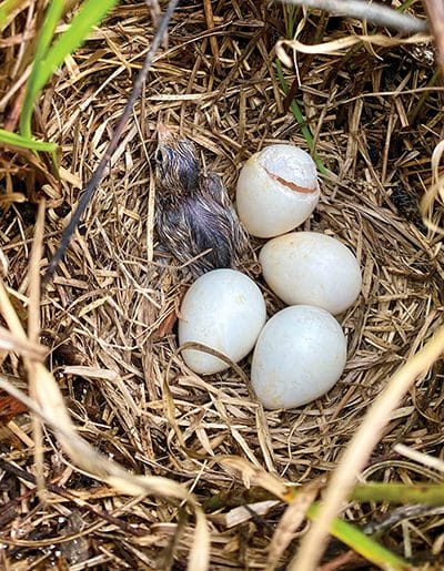 Quail Hatch Report in Anticipation of Quail Season