Obtain burn authorization from local Division of Forestry – day of burn.
Begin conducting prescribed burns as needed but be aware of drought conditions.
Do not till new firebreaks in wiregrass native groundcover.
Forestry
It is a relatively poor seed year for longleaf on some properties in the region. Delay burning one more year in blocks where you captured longleaf regeneration last year and notice seed germination this year.
Plant longleaf seedlings where needed.
Make plans for thinning and other cultural treatments in stands for periods of dry weather.
Game Bird
Prepare fire breaks to burn 50-60% of area in 25-500 acre patches depending on weather, populations, and predation.
Complete disking of fields for brood habitat.
Spread supplemental feed at 2 bu/ac/yr (we will customize each year).
Take soil samples in dove field.
Burn low areas and turkey woods in late February if dry.
Land Management
Complete any planting of mast-producing trees and shrubs as needed for wildlife food and cover.
Disk strips in fallow fields to promote ragweed and partridge pea for bobwhite quail.
Prescribe burn pine stands.
Lime/bottom plow old fields if needed.
Draw down moist soil management ponds for migrating shore birds.
Vertebrate Ecology
Clean and repair eastern bluebird nest boxes.
Clean and repair wood duck nest boxes; install new ones.
March Management Recommendations
Fire Ecology
Burning after bud break on woody stems (usually after March 1) appears to be the most effective means of reducing vigor of re-sprouting.
Consider burning stands of native grasses mixed with domestic grasses as this time of the year.
It is a moderately grassy year. Use ignition patterns that result in less intense burns and minimize crown scorch, e.g. spot ignition, lighting flanks into the wind, and using backing fire, instead of strip head fires.
Along major highways, minimize the distance burned along the highway edge in one day, and mop up aggressively to prevent smoke on the roads.
Do not till new firebreaks in wiregrass native groundcover.
Forestry
Because of the drought year poor mast year for longleaf on many properties, put off burning for 1-2 years in places where you captured regeneration last year.
Initiate timber stand improvement thinning, hardwood removal and other cultural treatments in forest stands.
Delay cutting in areas where heavy equipment will cause severe rutting.
Game Bird
Drain Duck Ponds and take soil samples.
Supplemental Feed at 2 bu/ac/yr.
Burn old-field lands now through April.
Nest predator management should begin now if needed.
Take time for dog training.
Land Management
Prepare wider fire lanes when burning during the driest time of year and always have water tanks available for suppression.
Avoid disking around wetlands and ponds as many reptiles and amphibians are actively moving to wetter areas for breeding.
Plant native grasses, forbs, and legumes.
Prepare for wildflower bloom season in late March in most parts of Florida as tubular flowers like honeysuckle will attract wildlife species, such as the ruby-throated hummingbird.
De-water flooded areas to promote growth of wetland vegetation.
Mow clover patches to stimulate re-growth while trying to avoid areas where ground nesting birds may lay eggs.
By Theron M. Terhune, Outreach Coordinator and Joe Noble, Technology Transfer Specialist
The late Steve Jobs, Apple visionary and creative guru, coined the catch-phrase: "There’s an App For That!" Slang for Application, an App is a simple but targeted application engineered for a specific task or suite of related tasks. Apps are not supposed to be an all-inclusive solution but rather a targeted task-specific solution designed to work quickly and efficiently. There are Native Computer Apps, Mobile Apps, and On-line Web Apps which may work independently or with other applications. MAPS are very similar to Apps in the sense that to ensure quality and efficiently communicate the targeted message; they should be simple, uncluttered and task-oriented.
What to know where in the entire US the nearest bike trail or birding trail is? There’s a mAP for that!
Do you want to know where the highest probability to successfully restore Northern Bobwhite Quail is? There’s a mAP for that! (BTW, this mAP was created by Tall Timbers.)
Along with many of you, I have read Herbert L. Stoddard’s seminal tome "The Bobwhite Quail: It’s Habitats, Preservation, and Increase" more times than I can count. I become more and more amazed each time I read it by how often Stoddard was right more times than he was wrong! This is despite not having the fancy gadgets and advanced technology (e.g., radio transmitters) we have today. Stoddard was indeed a very resourceful, observant, and meticulous naturalist. Above (left) is a map from 1948 that Stoddard created depicting soil classification and another map (above right, created by G.M. Church) depicting habitat classification on what is now Tall Timbers Research Station. By looking closely at these maps, one can ascertain that they were hand drawn and/or color-coded (using colored pencils of some sort) to delineate soil types, slope aspects, habitat types and suitability for management; and, notably, these maps appear to be to scale. I wonder how long it took Stoddard and Church to make these maps? Likewise, I wonder what projects were so important to warrant the time to create them? I would guess that these maps and others like it were pivotal to Stoddard’s precise assessment of the landscape, and the subsequent habitat management recommendations he made. For one reason or another, Stoddard was compelled to create and use maps. It begs the question: "How are you taking advantage of maps?" Is there really, or could there be, "a mAP for that!" to help you better plan, manage, and evaluate your property??
Of course you don’t need an App or a Map to tell you that things are much different today compared to Stoddard’s time. Thankfully, we no longer have to rely on colored pencils to make maps or even hand-draw maps to "see" our properties. Instead, we not only have the capability to create aesthetic, accurate and focused maps, but we have the ability to accomplish this relatively quickly with striking precision. To boot, we have the ability to seamlessly overlay different types of maps in order to evaluate certain habitat conditions and test specific management scenarios that aid us in making the best management decisions.
Tall Timbers Land Cover Map depicting specific habitat types, roads, course names, and various key feature labels.
If designed correctly, Apps and Maps can make one’s life easier and more productive as well as make things possible that at one time were very difficult to accomplish. Tall Timbers Outreach Program is currently working on the development of various interactive Web Apps and Mobile Apps for resource and land management purposes, to better equip Tall Timbers members with task-specific tools to aid in decision making and to foster exemplary land stewardship.
Want to know how big a field is on your property? We can help you have a mAP for that!
Want to know how long your feedline is? We can help you have a mAP for that!
Need to keep track of where/when you burn? We can help you have a mAP for that!
Tall Timbers Land Cover Map depicting specific 2010 Prescribed Burns (orange). Thus, upland sites not in orange would typically be burned the following year (2011).
We are fortunate to have a state of the art GIS lab at Tall Timbers. As such, we are equipped with large-scale map plotters, multiple mapping software programs and three experienced staff members with extensive GIS, GPS and mapping expertise available to help you create useful maps (see figure below) for your property. Whether you want a simple property map or a more detailed habitat map, we can help you have a mAP for that! Contact us for more information and details.
Prescribed burning in dry conditions creates a challenge for land managers
By Shane Wellendorf, Land Conservancy Conservation Coordinator
The 2011 year ended by being the second driest year on record in over 100 years. In Tallahassee, the rainfall deficit for the year was more than 24 inches. Throughout the region the effects of the drought have caused gum ponds, cypress domes, depression marshes, and small creeks to go dry. Even larger streams, such as Spring Creek, had zero flow for portions of the summer. The extended forecast, for the first three months in 2012, has predicted continued below average rainfall and above average temperatures, which means the continued drying of fuels and below normal water levels lead to exaggerated fire effects. If these predictions remain accurate, the spring prescribed burning conditions could be very dry and problematic.
The effects of the current drought can be observed throughout all habitats; and its impacts were even more evident on trees and plants that had been burned in the spring of 2011. Many types of forested wetlands that are adapted for periodic prescribed fires at low intensities have experienced, in recent years, more thorough and intense burning. Many larger established trees, including cypress, have showed signs of stress and some mortality has occurred due to recent fire. Additionally, there have been reports of peat/muck fires in cypress domes that have burned for months causing extensive long-term changes to the system. A prolonged dry period, such as predicted, has some people concerned about the effects of prescribed fires in forested wetlands for the upcoming burn season. Upland habitats were also influenced by the dry year we observed. Upland groundcover that typically responds favorably to fire has reduced structure and composition in many places throughout the region. The continued dry conditions have many landowners/managers evaluating their upcoming burn plans for 2012.
Managers and prescribed burners should consider taking a conservative approach to the amount of acres burned this season and to the intensity of fires used. A recommendation is to focus burning efforts exclusively on two-year or older roughs and problematic hardwood areas, and to minimize burning in last year’s burned stands. Quail oriented properties should focus on burning approximately 40-50% of their uplands versus the typical 60-70%. This should help to provide enough quality groundcover in the early portion of the breeding season and minimize predation. And, managers can always burn more in April and May if drought conditions don’t persist. Another consideration is to burn in smaller patch sizes, keeping burn patches in the 5 to 50-acre range, with adequate amounts of nearby unburned patches. Also, whenever possible, consider starting the burn season in January or February where the fires will not impact your quail hunting. By starting early you can capitalize on the wetter winter months and begin to slowly stagger your burning over to March and April. Burning smaller amounts each day, at smaller scales, over a longer period of time, should allow prescribed burners more flexibility to choose conditions that will create the best fire intensities for the conditions on the ground.
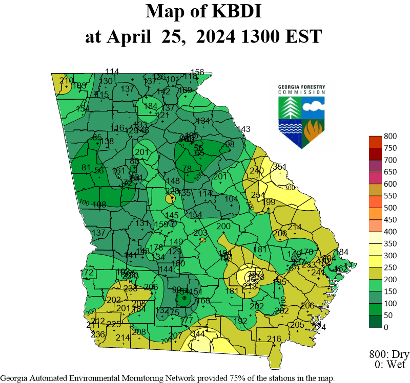
Prescribed burning in dry conditions creates a challenge for managers and prescribed burners because extreme fire intensity can be stressful on timber causing unwanted mortalities and long-term negative impacts to the system. When it’s dry, it is much more important to be observant of the affects of weather conditions on fire intensity. Understanding the effects of key weather parameters, such as days since last rainfall and relative humidity, on fire intensity is important. Additionally, fire intensities can be mitigated by the firing techniques used. Whenever possible, consider firing techniques, such as backing fires or spot head fires that could minimize fire intensity. Patience should be considered a virtue this season; backing fires will reduce fire intensity, but will still accomplish the desired hardwood control needed. Reducing fire intensity will be even more critical when burning more fire sensitive timber, such as in forested wetlands. Often this timber can handle low intensity fires, but hot fires will release a lot of heat that can kill mature trees and potentially start muck fires that can have long-term effects. Finally, another good tool for prescribed burners to consider using and understanding is the Keetch-Byram Drought Index (KBDI), which is a regional drought severity indicator used by state agencies to determine if burn authorizations will be allowed. For more information on the KBDI visit the Florida Forest Service website: http://www.fl-dof.com/fire_weather/information/kbdi.html, or Georgia website: http://weather.gfc.state.ga.us/Maps/kbdi.gif
Another consideration for conservative burning this year is the above average longleaf seed production seen throughout the region. The proliferation of seeds that dropped in November and December have begun to germinate and can be seen as little green wads of tender needles in places were mineral soil is exposed. Newly established longleaf seedlings are extremely susceptible to prescribed burning during their first year. To improve seedling survival chances, consider not burning this spring in localized areas, typically ranging in size from 0.5 to 25 acres. To maximize establishment of it is important that mature longleaf are nearby as a seed source and that the seed can make contact with mineral soil.
For many Tall Timbers members, the use of prescribed fire is absolutely critical for maintaining the forested landscapes we depend upon and appreciate. Therefore, in order to retain the respect of our neighbors, it is important as a unified group to be mindful of the impacts our fires and smoke have on the surrounding communities. While this is always true, it is especially important in a year such as this when, the use of prescribed fire may not seem as relevant in these current conditions. For more information please contact Tall Timbers at (850) 893-4153 x 226.
Tall Timbers saves nearly 7,000 acres with new conservation easements
By Kevin McGorty, Land Conservancy Director
Before the 2011 year’s end, Tall Timbers closed on four donated conservation easements totaling nearly 7,000 acres of land. Three of the easements are in the Red Hills.
The largest easement (3,165 acres) is Merrily Plantation which straddles the Georgia-Florida border in Thomas and Jefferson Counties. The property lies at an important geographic interface in the eastern Red Hills region, adding significant connectivity among existing conservation easements. The property has been owned by the Flowers family since the 1940s. Under their stewardship, Merrily Plantation is primarily managed for sustainable timber production, agriculture, and traditional sport hunting and shooting. Throughout the property, many older pine stands were carefully planted by the late William H. Flowers, Jr.; and after decades of quality stewardship, these planted stands have matured into a beautiful open pine forest. Merrily’s lowland habitats include forested wetlands associated with Connell Creek, Linton Lake, and the Aucilla River. Tall Timbers is honored to hold this very significant conservation easement.
In the above photo, some of the Flowers family members gather at Thanksgiving at Merrily Plantation. TOP ROW: (from left to right) Jameson McFadden, Benjamin McCollum, J. V. Shields, Jr., C. Martin Wood III and Guinness McFadden, Jr. SECOND ROW: Knox Miller, Haile McCollum, Anne-Fontaine McFadden, Daphne Flowers Wood, Lisa McFadden and the baby is Oliva McFadden. BOTTOM ROW: Caroline Miller, William McCollum, Eliza Miller, Parker McCollum, and Maury Flowers Shields.
In Leon County, W. Thorpe McKenzie added a 2,477 acre easement tract (formally a portion of Loveridge Plantation) to his beautiful Sunny Hill Plantation. From 1997 to 2000, Mr. McKenzie donated to Tall Timbers four phased conservation easements totaling 5,144 acres. With this newly added tract, Sunny Hill Plantation becomes the largest easement property in the Red Hills. In addition, this new easement provides a linear conservation corridor from the village of Miccosukee (National Register Historic District) north to Thomasville, Georgia, closing the gap between protected and unprotected lands in the Red Hills. The newly acquired tract is a shining example of a well managed, prescribed fire maintained, open pine forest that provides excellent habitat for northern bobwhites and other wildlife dependent upon frequently burned habitats. Additionally, Sunny Hill encompasses a portion of the Dry Creek floodplain, which has been designated as a Special Natural Area. The protection of the creek is important to the health of Lake Miccosukee and the Floridan Aquifer, a primary drinking water source for the region.
Tall Timbers third easement in 2011 was Shade Farm (621 acres) in Gadsden County, Florida. Like its name suggests, the history of land use on the property was primarily farming and agriculture in the 1900’s. Shade tobacco was a huge industry in Gadsden County. In 1946 Quincy, Florida was the third ranking city in Florida in the manufacturing of cigars. The property was purchased in 2005 by a group of ten partners mainly for quail, deer, and turkey hunting and productive forestry. Of significant conservation value are the approximately 173 acres of high quality bottomland forest that provide a buffer to Ziegler Mill and Smith Mill Creeks that flow south into Quincy Creek—once the main water supply for the city of Quincy. The protection of these creeks is important to the water quality of the Ochlockonee River Basin, which supports many species of rare plants and animals.
Outside the Red Hills, Tall Timbers completed a Phase I Easement for Leary Farm (417 acres) bordering Ichawaynochaway Creek in Calhoun County, Georgia. Tall Timbers holds other easements in this section of Southwest Georgia. The property was heavily stripped of timber in the 1950s. Since 1975 – under the DuPre family ownership – plantings of loblolly, slash, and longleaf have been ongoing. Mr. William DuPre IV and his sister Lelia DuPre Reynolds’ management goals for the property include sustainable forestry and wildlife management focusing on northern bobwhite, eastern wild turkey, and whitetail deer. Leary Farm supports high quality bottomland and floodplain forest associated with Ichawaynochaway Creek in the Flint River Basin. Due to the number of rare plant and animal species found in the Flint River watershed, the Georgia Department of Natural Resources has designated the Flint as a high priority watershed throughout its entirety.
With these new easements, Tall Timbers has now protected over 120,000 acres in the Red Hills and Southwest Georgia.
Quail carry-over, adults as nesters and burning for 2012
By Bill Palmer, Game Bird Program Director
Thus far our carry-over of quail has remained promising for the 2012 hatch, with 81% of radio-tagged birds remaining alive since November 1 on Tall Timbers and similar survival rate in Albany. This is excellent carry-over to date, but February and March are often the worst months for avian predation on quail, so we are not out of the woods yet. The forecast continues to predict drier and warmer weather through this period, which should help quail survival by keeping their main predators further north. Thus far this year, we are not seeing normal numbers of migratory flocking birds (blackbirds, robins, waxwings) as usual perhaps a result of warmer weather and low snow coverage in the Midwest and Eastern U.S. A good carry-over of bobwhite is critical if we are to remain stable or increase in 2012.
Some plantations are reporting higher than normal adult quail in their fall population. Previous research has indicated that productivity of adult and juvenile quail did not differ but our long-term studies indicate that adults are more productive nesters than juveniles and especially more so in some years (Figure 1). In 2000, 2004, 2006, and 2008 adult bobwhites were significantly more productive than juveniles, and three of these four years began an upswing in bobwhite numbers. During these years, adults produced 1.7-times the nests as juveniles. We believe much of this is due to adults starting nesting earlier in the year than juveniles, which adds time for renesting over the course of a nesting season. With a larger than normal proportion of our hatch coming from a late hatch, we may see adult bobwhites producing more nests in 2012 than juveniles; many juveniles will be 7 to 8 months old when nesting season begins. It is also interesting that in years with a strong May-June hatch our quail populations tend to increase. Previous studies in Tennessee indicated that the number of nests built by quail was the best indicator of summer population gain. The take home point is that while it is almost always a good sign to have a high juvenile to adult ratio in your fall population, our data suggests having a large proportion of adults may bode well for nest production the following year and help to increase populations.
The continued drought remains a concern for burning and habitat management this coming year. The main trade-off is maintaining adequate cover to get the quail through the avian predation threats in March (and get an advantage of our good carry-over of quail thus far), while getting the burning done before a potential burn ban occurs due to wild fires or severe drought. We are recommending burning conservatively (50% of uplands) and burning early in March and perhaps even some in February. If adequate rainfall occurs in February through April, then managers have the option to burn more acreage later in the season. This may apply more to areas with higher soil fertility or dense native ground cover, where the habitat can become rank rather than sandier sites. Last year, earlier burns benefited from moisture during March and provided better cover during the growing season than later burns, which were hampered by the drought in May and June. With a severe drought again in the forecast, we cannot bank on an early hatch. Therefore, maintaining quail survival is the key to sustaining populations; because if May and June are hot and dry, we will again depend on a later hatch for the 2012 hunting season. Keeping more of your quail alive until August may make a big difference next year, and how you burn this spring may very well be the most important management decision. There again, we can always hope that the drought may end!
The M-CORES program, which includes the proposed Suncoast Connector Toll Road in Jefferson County, passed through the Florida Legislature at breakneck speed with little review or analysis. Tall Timbers has a number of concerns given the potential for significant and wide spread impacts. These include fragmenting public and private conservation lands, robbing business from Main Street Monticello, impacting our rivers and other water resources, and making prescribed fire more difficult and costly.
Join us in asking the Jefferson County Board of County Commissioners to OPPOSE the Suncoast Connector toll road and its path through Jefferson County.
Take action now with our easy email form.
Send an email to all five Jefferson County Board of County Commissioners with one click!
Burn prioritization modeling seminars and fire modeling tools are supported by Wildland Fire Science to train managers in the important planning stages of prescribed fires.
Educating and guiding the next generation of fire researchers and managers is a key goal of Wildland Fire Science and a resource for testing new ideas in fire research.
Tall Timbers hosts the premier fire technology transfer organization—the Southern Fire Exchange. This JFSP funded effort helps connect research to management through webinars, workshops, and support of the Prescribed Fire Science Consortium.
Working with partners in the Prescribed Fire Science Consortium, the program is building nexgen 3-D fuel beds using terrestrial LiDAR and novel sampling techniques to power new fire behavior models for prescribed fire managers. This work links to Tall Timbers work in wildlife habitat usage and ecological forestry.
The Longleaf Legacy landscape prescribed fire burn team arm of Wildland Fire Science works directly with landowners and partners to effectively put fire on the ground and promote prescribed fire throughout the region.
Tall Timbers is leading an effort to map fire regimes at the landscape scale. Staff work with numerous agencies to evaluate fire records and satellite imagery to build this critical conservation database. https://skfb.ly/6DqOY
Tall Timbers hosts the Prescribed Fire Science Consortium, a national network of researchers and managers who promote integrated research and management to advance next generation tools for fire practitioners. https://arcg.is/1DSjDT
We are linking physics and field observations to understand the fluid dynamics of fire behavior surface fire regimes. Our work combines field observations using advanced thermal imaging techniques, laboratory studies, and coupled fire-atmospheric modeling to help managers improve outcomes of managed fire regimes.
Selected Publications authored by Wildland Fire Science staff.
Staff and researchers support Federal fire training by serving as a cadre for NWCG training courses, ranging from basic wildland fire to advanced fire effects.
(PFTC) specializes in training fire fighters the principles and techniques of prescribed fire through practical hands-on experience. https://www.fws.gov/fire/pftc/
Private land owners are the largest source of prescribed fire in the country. These land owners and the culture of fire that was maintained by them during decades of suppression are a part of why Tall Timbers is a world-wide center for prescribed fire science. Workshops and fire training are a critical focus of the Longleaf Legacy Landscape Burn Team and our support of the Georgia Forestry Commission Prescribed Fire Center in Marion County.
The conserved lands of the Greater Red Hills region are found on working, income-producing properties that support agriculture, forestry, and recreational hunting. These properties contribute $272 million annually to local economies and support 2,300 jobs. [link to Planning & Advocacy section] The landowners’ strong stewardship ethic preserves their working lands while replenishing drinking water supplies, protecting water quality, and providing wildlife habitat for dozens of rare and endangered species. Tall Timbers’ conservation easements on these working properties encourage landowners to retain their traditional livelihood by keeping farms in family ownership.
Home to world-class wild quail populations, the Greater Red Hills region contains the largest concentration of gamebird preserves in the United States. These preserves also support the largest community of Red-cockaded woodpeckers on private lands. Indicators of high quality habitat found here include the gopher tortoise, Bachman’s sparrow, fox squirrel, and many amphibians. Tall Timbers’ conservation easements identify and protect the critical habitats of these species.
The region also boasts outstanding aquatic resources. Large river systems, like the Flint/Apalachicola, Ochlockonee, and Aucilla, flow from Georgia and feed into the Gulf of Mexico to support some of the world’s most productive estuaries. Large disappearing sinkhole lakes, like Iamonia, Miccosukee, and Jackson, provide habitat for an array of aquatic species and migratory birds. Tall Timbers’ conservation easements protect these vital watersheds and wetlands that are the lifeblood for the ecological health of the region.
Once dominated by longleaf pine, our pine woodlands support abundant wildlife and local economies. These forests need prescribed fire to stay healthy. Herbert L. Stoddard and his associates Ed and Roy Komarek were pioneers in this emerging scientific field during the mid-20th century. Tall Timbers continues that legacy with applied research on prescribed fire and land management. Today, there is a tremendous need to expand prescribed fire use beyond the Red Hills to ensure ecosystem health and reduce wildfire risk. Additionally, Tall Timbers uses conservation easements to permanently protect private woodlands while balancing the need for economic return from selective timbering.


 In Leon County, W. Thorpe McKenzie added a 2,477 acre easement tract (formally a portion of Loveridge Plantation) to his beautiful Sunny Hill Plantation. From 1997 to 2000, Mr. McKenzie donated to Tall Timbers four phased conservation easements totaling 5,144 acres. With this newly added tract, Sunny Hill Plantation becomes the largest easement property in the Red Hills. In addition, this new easement provides a linear conservation corridor from the village of Miccosukee (National Register Historic District) north to Thomasville, Georgia, closing the gap between protected and unprotected lands in the Red Hills. The newly acquired tract is a shining example of a well managed, prescribed fire maintained, open pine forest that provides excellent habitat for northern bobwhites and other wildlife dependent upon frequently burned habitats. Additionally, Sunny Hill encompasses a portion of the Dry Creek floodplain, which has been designated as a Special Natural Area. The protection of the creek is important to the health of Lake Miccosukee and the Floridan Aquifer, a primary drinking water source for the region.
 Tall Timbers third easement in 2011 was Shade Farm (621 acres) in Gadsden County, Florida. Like its name suggests, the history of land use on the property was primarily farming and agriculture in the 1900’s. Shade tobacco was a huge industry in Gadsden County. In 1946 Quincy, Florida was the third ranking city in Florida in the manufacturing of cigars. The property was purchased in 2005 by a group of ten partners mainly for quail, deer, and turkey hunting and productive forestry. Of significant conservation value are the approximately 173 acres of high quality bottomland forest that provide a buffer to Ziegler Mill and Smith Mill Creeks that flow south into Quincy Creek—once the main water supply for the city of Quincy. The protection of these creeks is important to the water quality of the Ochlockonee River Basin, which supports many species of rare plants and animals.


