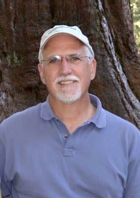
With the recent passing of Board member George W. Willson, Floridians and the Tall Timbers community have lost one of the most accomplished land conservationists in the state.
George has been attributed with saving nearly one million acres of environmentally sensitive land from the Keys to the Panhandle. “Probably nobody that’s has ever been involved in land acquisition in Florida has done more than George Willson. He spent four decades fighting to preserve Florida’s ecology,” said Estus Whitfield, former principal environmental advisor to four Florida governors.
With laser precision of his Marine Corps training, George was the consummate “deal maker,” negotiating fairly with private landowners to save incredible tracts of land from development threat. As Director of Land Acquisition for the Florida chapter of The Nature Conservancy (TNC) from 1984-1999, he was in command in securing vast properties, like the 18,000-acre Walton County tracts that later became Topsail Hill Preserve State Park and Point Washington State Forest.
After leaving TNC, George became Vice-President for Conservation Lands at the St. Joe Company. As Florida’s largest landowner, the company transferred from its portfolio to the State key holdings for public benefit and enjoyment.
Since 1989, George had a long association with Tall Timbers. He was one of the founding members of the Red Hills Conservation Association, the precursor of today’s Tall Timbers Land Conservancy. He was instrumental in guiding Tall Timbers to become one of the nation’s leading accredited land trusts.
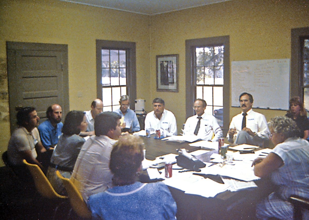
Consortium meeting of the Red Hills Conservation Association at Tall Timbers, c. 1989. George Willson pictured third from left in white shirt.
A walking encyclopedia on land conservation transactions, George was a generous mentor to our organization. His spirit will live on and his lasting legacy will be enjoyed by this and future generations who experience the special natural places he so dedicatedly saved and loved.
Economic Trade-Offs and Quail Management Field Workshop
Friday, September 27 Belmont Plantation Louisville, Georgia
The Economic Trade-Offs and Quail Management Field Workshop is an event where attendees will see firsthand the ongoing habitat renovations and land management techniques being used to overcome common challenges faced when managing for high densities of wild quail. Area experts will present on current research and specific techniques used to overcome these and other challenges managers face across the Carolinas. Registration is now open. Click here to register.
Safe Harbor Workshop
Thursday, October 10
The Jones Center at Ichauway Newton, Georgia
The workshop will be hosted by the Jones Center at Ichauway, Tall Timbers, and Georgia Department of Natural Resources. Staff will provide background on woodpecker habitat needs and management and the benefits of the Safe Harbor Program. Field tours will visit prime woodpecker habitat and also demonstrate first-hand some of the tools used to manage woodpecker populations. We’ll also review some of the cost-share programs available with a strong focus on properties support the woodpecker. For more preliminary information, contact Jim Cox. Registration is required to help plan for logistics and distribute materials beforehand. To register, please email Amy Allen; or call 850-893-4153 x249.
Orvis Fly Fishing School
Saturday, October 12 • 9 AM–4 PM
at Tall Timbers
Cost: $240.00 per person • Only 2 spots left! Use of Orvis tackle and lunch included RSVP by email to Amy Allen or call her at 850-893-4153 x249
If learning to fly fish or improving your casting technique seems like a daunting task, you just haven’t met the right fishing instructors. Truel Myers, the head fly fishing instructor for Orvis, will help you with everything from setting up the rod, to fly selection and knots, to how to safely release your catch. No matter the skill level, you’ll leave with the knowledge and know-how to cast like a seasoned angler.
Red Hills Fall Field Day
Friday, October 18 Four Oaks Plantation
Boston, Georgia
The Red Hills Fall Field Day is an event where attendees will see firsthand the ongoing habitat renovations and land management techniques being used to overcome common challenges faced when managing for high densities of wild quail. Area experts will present on current research and specific techniques used to overcome these and other challenges managers face across the Southeast. Registration is now open. Click here to register. For more information, please contact the Development Office: Crystal Davis Rice at 850.545.3675 / email Crystal; Amy Allen at 850.893.4153, x249 / email Amy.
South Carolina Bobwhite Funding Partnership Event & Auction
Thursday, October 24 The Millstone at Adam’s Pond Columbia, South Carolina
In 2017, Tall Timbers and South Carolina Department of Natural Resources signed a Memorandum of Agreement to form the SC Bobwhite Funding Partnership. The purpose of this partnership is to raise funds from corporate and private sources and use them for bobwhite work across the Carolinas. Please join us for an evening reception and auction. The proceeds from this event help fund the South Carolina Bobwhite Initiative, as well as Tall Timbers’ Carolina Regional Quail Project’s efforts in South Carolina. For more information, please contact the Development Office: Crystal Davis Rice at 850.545.3675 / email Crystal; Amy Allen at 850.893.4153, x249 / email Amy.
Kevin’s and Holland & Holland’s 4th Annual Southern Game Fair
The Kevin’s Annual Game Fair, benefiting Tall Timbers, is an opportunity to share our love of the outdoors with the community, to celebrate the heritage of Thomasville, GA, and support the preservation of the longleaf pine forest and bobwhite quail habitat of the Red Hills region.
This year’s Game Fair kicks off Thursday evening, November 7, 2019 with Buffalo Trace Cocktail Party, along with gun room chats with Guy Davie from Holland & Holland and Kevin Kelly, CEO of Kevin’s, a live auction featuring world class sporting trips, a VIP shooting experience at the London Holland & Holland shooting grounds, plus an extraordinary opportunity to hunt wild quail at the exclusive Dixie Plantation in Monticello, Florida.
The Game Fair takes place Friday, Nov. 8, 2019, 9:00 a.m. at the historical and private Greenwood Plantation Campus. Enjoy a day full of activities:
Celebrating Veterans
Cooking demonstrations
Fly fishing demonstrations
Tall Timbers discussion about controlled burn program and wildlife
Quail wagon rides with Clydesdales
Famous DockDogs Competition. (Your dogs can compete)
Wildrose Kennels • Ryglen Gundogs
Pointing Dog Demonstrations
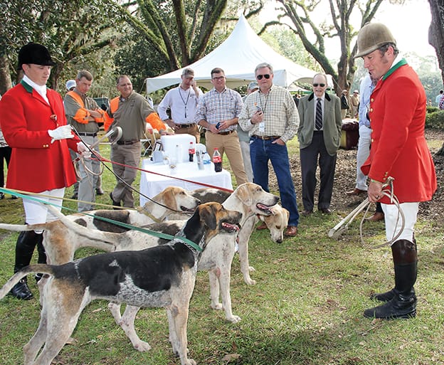
Live Oak Farms Fox Hounds
Delicious plantation lunch and many more activities!
Thanks to long-time supporter, Leon County Commissioner Bryan Desloge, Tall Timbers was recently honored by the Leon County Commission for our contributions over more than 60 years as a leader in natural resource research, land conservation, and education. The Leon County Commission’s proclamation recognized Tall Timbers as a “premier biological research station that is: the birthplace of fire ecology research, the home of the Prescribed Fire Science Consortium, the home of the South’s premier quail research program and the Stoddard Bird lab.” The County’s proclamation also highlighted Tall Timbers success as a nationally recognized and accredited land conservancy protecting nearly 150,000 acres in the Red Hills region and other critical landscapes.
Commissioner Desloge also discussed the nearly $200 million economic impact of quail hunting in the Red Hills region and the many jobs and businesses that benefit from Red Hills working rural lands. In his comments, CEO Bill Palmer highlighted the success of Tall Timbers’ diverse programs and the increasing national role the organization is taking on regarding the importance of using prescribed fire to reduce destructive wildfire. Tall Timbers is extremely grateful to Commissioner Bryan Desloge and the entire Leon County Commission for recognizing Tall Timbers contributions to our local community, the region and nation.
L-R, Neil Fleckenstein, Tall Timbers Planning Coordinator, Bryan Desloge, Leon County Commissioner, and Bill Palmer, Tall Timbers President, CEO
Using LANDSAT Burned Area Products to Map Fires Across Florida
Tall Timbers staff recently completed a collaborative project that mapped the footprint of fire across the state of Florida. Florida leads the nation in prescribed burning accomplishments with between 1-2 million acres of prescribed fire approved annually (approximately 10% of total fire area burned nationally). This is especially impressive as nearly 70% of the state is in private ownership, and accounts for many of these fires. Florida has had a method for tracking the permitting of fires for over a decade. The Florida Forest Service requires prescribed burners to submit a request to burn to an Open Burn Authorization (OBA) system. Approved burns are tracked, including information such as size, date, time, and purpose. However, the fire locations are recorded as points, and more than one ‘burn unit’ can be associated with a single OBA point. This can be an issue for conservation and management prioritization purposes, where actual spatial area information about fires may be required.
The goal of this project was to utilize satellite-based data products to derive the spatial extents (e.g., boundaries) of burned areas in Florida in order to show the extent of fires across the state. We used the USGS LANDSAT Burned Area (version 2; BAv2) products to map burned areas for the period 2006 to 2018. Datasets provided by public and private landowners around the state were used to corroborate the products and improve upon them; meetings showing the products to land managers were very useful – land managers provided suggestions on where fires were being mapped accurately as well as when and where there were challenges.
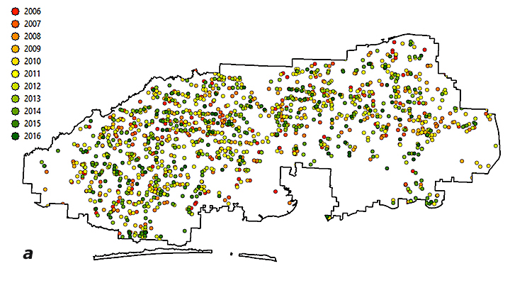
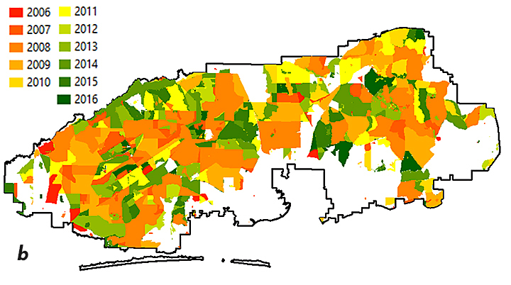
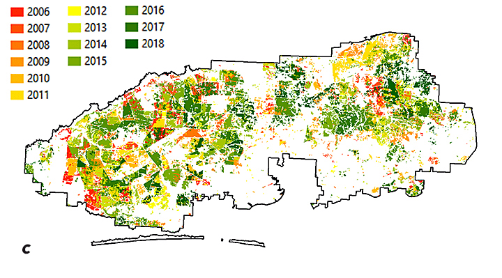
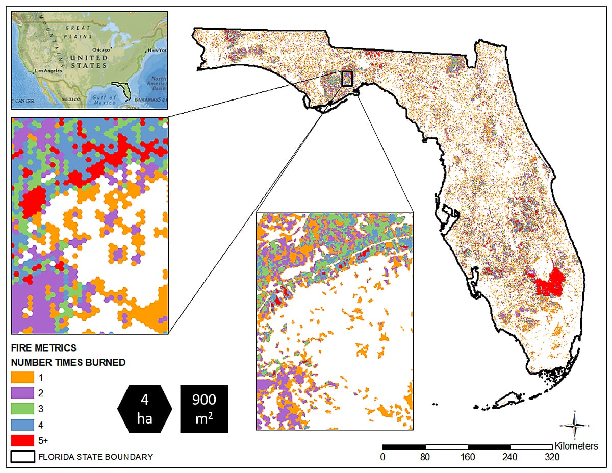
We mapped fires greater than 2.5-acres across the state. You can see how the different methods of displaying fire history data vary and the utility associated with each method (Figure 1).
Figure 1: Maps using different data sources to show “year last burned” on Eglin Air Force Base. FFS OBA data for 2006-2016 depict the amount of burning, but not the location (a); landowner provided fire history shows units where fire was applied and when (b); BAv2-derived fire extents show where and when a fire was detected, including the mosaic within a burn unit (c).
Perhaps the biggest benefit of this process is that fire history metrics were calculated for all areas in the state, no matter the administrative/ownership responsibility. These metrics include season of burn, number of times burned, longest fire-free period, year last burned and time since previous burn. These types of metrics allow for conservation and management prioritization activities — some of which are heavily influenced by an area’s fire history — to be evaluated in a robust manner (Figure 2).
Figure 2: Number of Times Burned within each 10-acre (4-ha) cell between 2006 to 2018. We mapped all fires, but the 30-m resolution that the 2.5-acre fires are mapped is difficult to see at the state level, so we display them as ‘summaries’ over a larger area in order to highlight areas of interest. From there, a manager can zoom in to the actual 2.5-acre mapped data to determine specifics on what is happening on a given piece of ground. The comparison is shown in the two boxes.
We extend our thanks to the Florida Fish and Wildlife Conservation Commission and the Peninsular Florida Landscape Conservation Cooperative for funding, the US Geological Survey for data acquisition and processing assistance, and the many public and private landowners that provided burn history data for use in validating these products.
If you would like information on how to work with Tall Timbers for your area of interest, or have suggestions for other fire history metrics that would be of interest, please let us know. We want our products to be useful in the field! You can contact Casey Teske (cteske@talltimbers.org) or Joe Noble (jnoble@talltimbers.org) for more information about the fire mapping outputs. More information about the USGS Burned Area products can be found on the USGS website: https://www.usgs.gov/land-resources/nli/landsat/landsat-burned-area.
Friday, November 1 • 7:30 AM – 1:00 PM Black River Plantation | Georgetown County, SC
Black River Plantation is a 1500-acre property in Georgetown County, South Carolina located on the outer banks of the Black River. This is an exquisite prop¬erty steeped in tradition with a magnificent plantation house listed on the historic National Registry and long-term habitat management goals of restoring native Longleaf Pine ecosystems. Recent land management efforts have focused on the conversion of Loblolly timber stands to native Longleaf and reclaiming forested uplands to quality bobwhite habitat.
Today, Black River is a prime example of how one can overcome challenges often faced outside the tradi¬tional quail belt to successfully produce bobwhite habitat. The dedication to bringing back bobwhites on Black River Plantation is obvious and unparalleled. Come join us as we discuss their management success and enjoy the rich tradition of Black River Planation!
The M-CORES program, which includes the proposed Suncoast Connector Toll Road in Jefferson County, passed through the Florida Legislature at breakneck speed with little review or analysis. Tall Timbers has a number of concerns given the potential for significant and wide spread impacts. These include fragmenting public and private conservation lands, robbing business from Main Street Monticello, impacting our rivers and other water resources, and making prescribed fire more difficult and costly.
Join us in asking the Jefferson County Board of County Commissioners to OPPOSE the Suncoast Connector toll road and its path through Jefferson County.
Take action now with our easy email form.
Send an email to all five Jefferson County Board of County Commissioners with one click!
Burn prioritization modeling seminars and fire modeling tools are supported by Wildland Fire Science to train managers in the important planning stages of prescribed fires.
Educating and guiding the next generation of fire researchers and managers is a key goal of Wildland Fire Science and a resource for testing new ideas in fire research.
Tall Timbers hosts the premier fire technology transfer organization—the Southern Fire Exchange. This JFSP funded effort helps connect research to management through webinars, workshops, and support of the Prescribed Fire Science Consortium.
Working with partners in the Prescribed Fire Science Consortium, the program is building nexgen 3-D fuel beds using terrestrial LiDAR and novel sampling techniques to power new fire behavior models for prescribed fire managers. This work links to Tall Timbers work in wildlife habitat usage and ecological forestry.
The Longleaf Legacy landscape prescribed fire burn team arm of Wildland Fire Science works directly with landowners and partners to effectively put fire on the ground and promote prescribed fire throughout the region.
Tall Timbers is leading an effort to map fire regimes at the landscape scale. Staff work with numerous agencies to evaluate fire records and satellite imagery to build this critical conservation database. https://skfb.ly/6DqOY
Tall Timbers hosts the Prescribed Fire Science Consortium, a national network of researchers and managers who promote integrated research and management to advance next generation tools for fire practitioners. https://arcg.is/1DSjDT
We are linking physics and field observations to understand the fluid dynamics of fire behavior surface fire regimes. Our work combines field observations using advanced thermal imaging techniques, laboratory studies, and coupled fire-atmospheric modeling to help managers improve outcomes of managed fire regimes.
Selected Publications authored by Wildland Fire Science staff.
Staff and researchers support Federal fire training by serving as a cadre for NWCG training courses, ranging from basic wildland fire to advanced fire effects.
(PFTC) specializes in training fire fighters the principles and techniques of prescribed fire through practical hands-on experience. https://www.fws.gov/fire/pftc/
Private land owners are the largest source of prescribed fire in the country. These land owners and the culture of fire that was maintained by them during decades of suppression are a part of why Tall Timbers is a world-wide center for prescribed fire science. Workshops and fire training are a critical focus of the Longleaf Legacy Landscape Burn Team and our support of the Georgia Forestry Commission Prescribed Fire Center in Marion County.
The conserved lands of the Greater Red Hills region are found on working, income-producing properties that support agriculture, forestry, and recreational hunting. These properties contribute $272 million annually to local economies and support 2,300 jobs. [link to Planning & Advocacy section] The landowners’ strong stewardship ethic preserves their working lands while replenishing drinking water supplies, protecting water quality, and providing wildlife habitat for dozens of rare and endangered species. Tall Timbers’ conservation easements on these working properties encourage landowners to retain their traditional livelihood by keeping farms in family ownership.
Home to world-class wild quail populations, the Greater Red Hills region contains the largest concentration of gamebird preserves in the United States. These preserves also support the largest community of Red-cockaded woodpeckers on private lands. Indicators of high quality habitat found here include the gopher tortoise, Bachman’s sparrow, fox squirrel, and many amphibians. Tall Timbers’ conservation easements identify and protect the critical habitats of these species.
The region also boasts outstanding aquatic resources. Large river systems, like the Flint/Apalachicola, Ochlockonee, and Aucilla, flow from Georgia and feed into the Gulf of Mexico to support some of the world’s most productive estuaries. Large disappearing sinkhole lakes, like Iamonia, Miccosukee, and Jackson, provide habitat for an array of aquatic species and migratory birds. Tall Timbers’ conservation easements protect these vital watersheds and wetlands that are the lifeblood for the ecological health of the region.
Once dominated by longleaf pine, our pine woodlands support abundant wildlife and local economies. These forests need prescribed fire to stay healthy. Herbert L. Stoddard and his associates Ed and Roy Komarek were pioneers in this emerging scientific field during the mid-20th century. Tall Timbers continues that legacy with applied research on prescribed fire and land management. Today, there is a tremendous need to expand prescribed fire use beyond the Red Hills to ensure ecosystem health and reduce wildfire risk. Additionally, Tall Timbers uses conservation easements to permanently protect private woodlands while balancing the need for economic return from selective timbering.