Red-cockaded Woodpecker nest discovered on Dixie—the first in 50 years!
Red-cockaded Woodpeckers are nesting on Dixie Plantation in Jefferson County, Florida. Eight sub-adults were translocated to the property last fall, and a nest with four eggs was discovered today by Woodpecker Conservation Specialist Rob Meyer. This is the first nest on the property in over 50 years! We’ll be scheduling a special trip to band the young once they appear and reach an approach age (probably in early June). The restored woodpecker population on Tall Timbers also reached a new high in 2019—16 nests underway at this point with about half the nestlings banded.
Bobwhite Breeding Season Begins with High Optimism
By Dr. Theron M. Terhune, Game Bird Program Director
As the final smoke plumes dissipate in the springtime air, birds are pairing off hard and dispersing in search for mates over the past few weeks. As of this writing, 15 May, we have confirmed 25 nests being incubated in the Red Hills region and already a few managers have reported seeing a brood or two. We expect to begin seeing good numbers of chicks hitting the ground by late May and early June. As such, if not already done it would be a good idea to begin wrapping up woods work, if possible, to minimize negative impacts on early broods — many of these early broods will likely be roosting in unburned areas and using the recently burned areas for bugging grounds.
Quail Roosting
In looking back, over-winter survival was about average to slightly above average this year based on our radio-tagged birds. We’ve also had good spring rains so far resulting in a quick cover response following burns on many properties. The raptors left in a hurry around mid-March, which has further benefited adult survival, rendering good numbers being carried into breeding season. In addition, we have been seeing and hearing a lot of reports of a high number of cotton rats. In our small mammal sampling this past month, we also observed a large uptick in cotton rat numbers compared to previous years at this same time, and very comparable numbers to that of 2002-03 seasons. We are hopeful that this boom in cotton rat numbers continues and that this will result in good breeding season survival for adult bobwhite, yielding good production, good chick survival, and that this results in excellent fall recruitment.
Speaking of chicks and recruitment. One of our PhD students, Brad Kubecka, is studying various aspects of chick ecology, and he recently analyzed spatial daily movements for broods and developed this nifty animation for six chicks (radio-tracking of single members of different broods) from the 2018 breeding season.
Figure Above: Grey represents recently burned (3 month) areas, whereas white represents areas burned the year before (15 months). Beige colors are fallow fields and dark green are hardwood bottoms, or drains. Feed lines are blue.
What you can see is that broods are using both burned and unburned areas with a preference toward recently burned areas for foraging. You might also notice that some broods make bigger movements than what you might think. Also, chicks have a propensity for the feed line, especially as they mature, with some broods using the feed line as early as two weeks of age, which is slightly earlier than what we have previously thought. Stoddard suggested that we do not know if the chicks are consuming insects or milo or both along these feed lines, but our future analysis of chick feces will shed light on the diets of chicks. The take-home message is simple: feed, feed and feed!! The adult birds, rats and chicks all benefit from feed being on the ground year-round, and this time of year is a major pinch-point in survival for bobwhite, so keeping the feed abundantly available will help to mitigate the taxing conditions of breeding/mating.
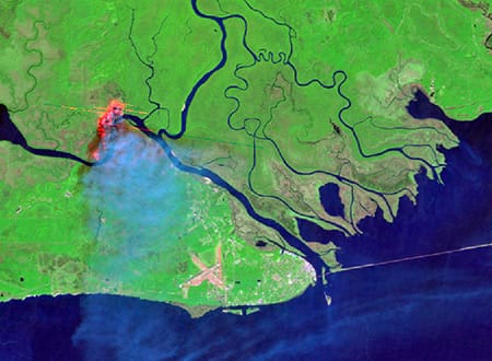
Using LANDSAT Burned Area Products to Map Fires Across Florida
Tall Timbers staff recently completed a collaborative project that mapped the footprint of fire across the state of Florida. Florida leads the nation in prescribed burning accomplishments with between 1-2 million acres of prescribed fire approved annually (approximately 10% of total fire area burned nationally). This is especially impressive as nearly 70% of the state is in private ownership, and accounts for many of these fires. Florida has had a method for tracking the permitting of fires for over a decade. The Florida Forest Service requires prescribed burners to submit a request to burn to an Open Burn Authorization (OBA) system. Approved burns are tracked, including information such as size, date, time, and purpose. However, the fire locations are recorded as points, and more than one ‘burn unit’ can be associated with a single OBA point. This can be an issue for conservation and management prioritization purposes, where actual spatial area information about fires may be required.
The goal of this project was to utilize satellite-based data products to derive the spatial extents (e.g., boundaries) of burned areas in Florida in order to show the extent of fires across the state. We used the USGS LANDSAT Burned Area (version 2; BAv2) products to map burned areas for the period 2006 to 2018. Datasets provided by public and private landowners around the state were used to corroborate the products and improve upon them; meetings showing the products to land managers were very useful – land managers provided suggestions on where fires were being mapped accurately as well as when and where there were challenges.
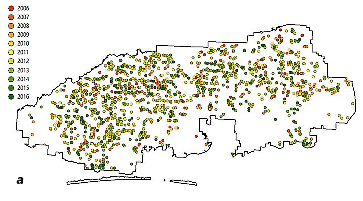
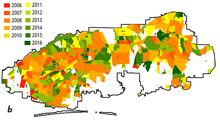
We mapped fires greater than 2.5-acres across the state. You can see how the different methods of displaying fire history data vary and the utility associated with each method (Figure 1).
Figure 1: Maps using different data sources to show “year last burned” on Eglin Air Force Base. FFS OBA data for 2006-2016 depict the amount of burning, but not the location (a); landowner provided fire history shows units where fire was applied and when (b); BAv2-derived fire extents show where and when a fire was detected, including the mosaic within a burn unit (c).
Perhaps the biggest benefit of this process is that fire history metrics were calculated for all areas in the state, no matter the administrative/ownership responsibility. These metrics include season of burn, number of times burned, longest fire-free period, year last burned and time since previous burn. These types of metrics allow for conservation and management prioritization activities — some of which are heavily influenced by an area’s fire history — to be evaluated in a robust manner (Figure 2).
Figure 2: Number of Times Burned within each 10-acre (4-ha) cell between 2006 to 2018. We mapped all fires, but the 30-m resolution that the 2.5-acre fires are mapped is difficult to see at the state level, so we display them as ‘summaries’ over a larger area in order to highlight areas of interest. From there, a manager can zoom in to the actual 2.5-acre mapped data to determine specifics on what is happening on a given piece of ground. The comparison is shown in the two boxes.
We extend our thanks to the Florida Fish and Wildlife Conservation Commission and the Peninsular Florida Landscape Conservation Cooperative for funding, the US Geological Survey for data acquisition and processing assistance, and the many public and private landowners that provided burn history data for use in validating these products.
If you would like information on how to work with Tall Timbers for your area of interest, or have suggestions for other fire history metrics that would be of interest, please let us know. We want our products to be useful in the field! You can contact Casey Teske (cteske@talltimbers.org) or Joe Noble (jnoble@talltimbers.org) for more information about the fire mapping outputs. More information about the USGS Burned Area products can be found on the USGS website: https://www.usgs.gov/land-resources/nli/landsat/landsat-burned-area.
Friday, November 1 • 7:30 AM – 1:00 PM Black River Plantation | Georgetown County, SC
Black River Plantation is a 1500-acre property in Georgetown County, South Carolina located on the outer banks of the Black River. This is an exquisite prop¬erty steeped in tradition with a magnificent plantation house listed on the historic National Registry and long-term habitat management goals of restoring native Longleaf Pine ecosystems. Recent land management efforts have focused on the conversion of Loblolly timber stands to native Longleaf and reclaiming forested uplands to quality bobwhite habitat.
Today, Black River is a prime example of how one can overcome challenges often faced outside the tradi¬tional quail belt to successfully produce bobwhite habitat. The dedication to bringing back bobwhites on Black River Plantation is obvious and unparalleled. Come join us as we discuss their management success and enjoy the rich tradition of Black River Planation!
5 Stand is a type of shotgun sport shooting similar to sporting clays, trap and skeet. There are five stations, or stands and six to eighteen strategically placed clay target throwers(called traps). Shooters shoot in turn at various combinations of clay birds. Each station will have a menu card that lets the shooter know the sequence of clay birds he or she will be shooting at (i.e. which trap the clay bird will be coming from). The shooter is presented with 5 targets at each station, first a single bird followed by two pairs. Pairs can be either “report pairs,” in which the second bird will be launched after the shooter fires at the first; or “true pairs” when both birds launch at the same time. After shooting at the 5 birds on the menu at that station, the shooter proceeds to the next stand, where they find a new menu of 5 targets.
Typical five stand targets are a rabbit, chandelle, overhead, standard skeet high house and low house shots, teal (launched straight up into the air), trap (straight ahead from ground level), and an incoming bird.
Rotation starts at 9am – Brunch served
Limited to 40 participants
Pre-registration required by 4pm on Friday, September 16th
Five Stand Shoot – 50 targets
Any gauge gun, 1-ounce shot or less
$100 Entry Fee
Rules will be provided upon inquiry/registration.
Prizes award to:
1st place – $500, engraved Yeti cup
2nd place – $300, engraved Yeti cup
3rd place – $200, engraved Yeti cup
10th place – engraved Yeti cup
To register for 5 Stand Sporting Shoot, click here.
Winners will be announced at the 19th Annual Kate Ireland Memorial Dinner & Auction on Sunday, September 18th, Glen Arven Country Club – tickets additional – Register online at talltimbers.org
For More Information
Contact:Dale Fuller, Tall Timbers Research Station & Land Conservancy
850-893-4153 ext. 343 | dfuller@ttrs.org
The M-CORES program, which includes the proposed Suncoast Connector Toll Road in Jefferson County, passed through the Florida Legislature at breakneck speed with little review or analysis. Tall Timbers has a number of concerns given the potential for significant and wide spread impacts. These include fragmenting public and private conservation lands, robbing business from Main Street Monticello, impacting our rivers and other water resources, and making prescribed fire more difficult and costly.
Join us in asking the Jefferson County Board of County Commissioners to OPPOSE the Suncoast Connector toll road and its path through Jefferson County.
Take action now with our easy email form.
Send an email to all five Jefferson County Board of County Commissioners with one click!
Selected Publications authored by Wildland Fire Science staff.
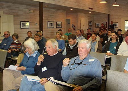
Educating and guiding the next generation of fire researchers and managers is a key goal of Wildland Fire Science and a resource for testing new ideas in fire research.
Tall Timbers hosts the Prescribed Fire Science Consortium, a national network of researchers and managers who promote integrated research and management to advance next generation tools for fire practitioners. https://arcg.is/1DSjDT
Working with partners in the Prescribed Fire Science Consortium, the program is building nexgen 3-D fuel beds using terrestrial LiDAR and novel sampling techniques to power new fire behavior models for prescribed fire managers. This work links to Tall Timbers work in wildlife habitat usage and ecological forestry.
Tall Timbers is leading an effort to map fire regimes at the landscape scale. Staff work with numerous agencies to evaluate fire records and satellite imagery to build this critical conservation database. https://skfb.ly/6DqOY
We are linking physics and field observations to understand the fluid dynamics of fire behavior surface fire regimes. Our work combines field observations using advanced thermal imaging techniques, laboratory studies, and coupled fire-atmospheric modeling to help managers improve outcomes of managed fire regimes.
Burn prioritization modeling seminars and fire modeling tools are supported by Wildland Fire Science to train managers in the important planning stages of prescribed fires.
The conserved lands of the Greater Red Hills region are found on working, income-producing properties that support agriculture, forestry, and recreational hunting. These properties contribute $272 million annually to local economies and support 2,300 jobs. [link to Planning & Advocacy section] The landowners’ strong stewardship ethic preserves their working lands while replenishing drinking water supplies, protecting water quality, and providing wildlife habitat for dozens of rare and endangered species. Tall Timbers’ conservation easements on these working properties encourage landowners to retain their traditional livelihood by keeping farms in family ownership.
Home to world-class wild quail populations, the Greater Red Hills region contains the largest concentration of gamebird preserves in the United States. These preserves also support the largest community of Red-cockaded woodpeckers on private lands. Indicators of high quality habitat found here include the gopher tortoise, Bachman’s sparrow, fox squirrel, and many amphibians. Tall Timbers’ conservation easements identify and protect the critical habitats of these species.
The region also boasts outstanding aquatic resources. Large river systems, like the Flint/Apalachicola, Ochlockonee, and Aucilla, flow from Georgia and feed into the Gulf of Mexico to support some of the world’s most productive estuaries. Large disappearing sinkhole lakes, like Iamonia, Miccosukee, and Jackson, provide habitat for an array of aquatic species and migratory birds. Tall Timbers’ conservation easements protect these vital watersheds and wetlands that are the lifeblood for the ecological health of the region.
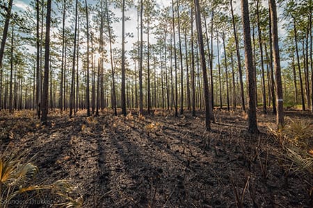
Once dominated by longleaf pine, our pine woodlands support abundant wildlife and local economies. These forests need prescribed fire to stay healthy. Herbert L. Stoddard and his associates Ed and Roy Komarek were pioneers in this emerging scientific field during the mid-20th century. Tall Timbers continues that legacy with applied research on prescribed fire and land management. Today, there is a tremendous need to expand prescribed fire use beyond the Red Hills to ensure ecosystem health and reduce wildfire risk. Additionally, Tall Timbers uses conservation easements to permanently protect private woodlands while balancing the need for economic return from selective timbering.
Tall Timbers hosts the premier fire technology transfer organization—the Southern Fire Exchange. This JFSP funded effort helps connect research to management through webinars, workshops, and support of the Prescribed Fire Science Consortium.
The Longleaf Legacy landscape prescribed fire burn team arm of Wildland Fire Science works directly with landowners and partners to effectively put fire on the ground and promote prescribed fire throughout the region.
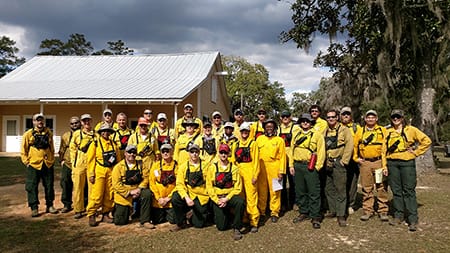
Staff and researchers support Federal fire training by serving as a cadre for NWCG training courses, ranging from basic wildland fire to advanced fire effects.
(PFTC) specializes in training fire fighters the principles and techniques of prescribed fire through practical hands-on experience. https://www.fws.gov/fire/pftc/
Private land owners are the largest source of prescribed fire in the country. These land owners and the culture of fire that was maintained by them during decades of suppression are a part of why Tall Timbers is a world-wide center for prescribed fire science. Workshops and fire training are a critical focus of the Longleaf Legacy Landscape Burn Team and our support of the Georgia Forestry Commission Prescribed Fire Center in Marion County.